Matlapa elevation
Matlapa (San Luis Potosí), Mexico elevation is 131 meters and Matlapa elevation in feet is 430 ft above sea level [src 1]. Matlapa is a seat of a second-order administrative division (feature code) with elevation that is 1183 meters (3881 ft) smaller than average city elevation in Mexico.
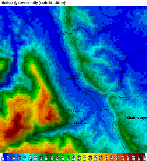
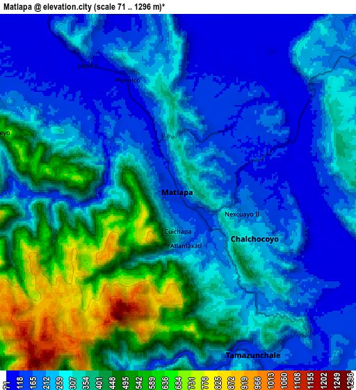
Below is the Elevation map of Matlapa, which displays elevation range with different colors. Scale of the first map is from 98 to 961 m (322 to 3153 ft) with average elevation of 288.3 meters (=946 ft) [note 1]
These maps also provides idea of topography and contour of this city, they are displayed at different zoom levels. More info about maps, scale and edge coordinates you can find below images.
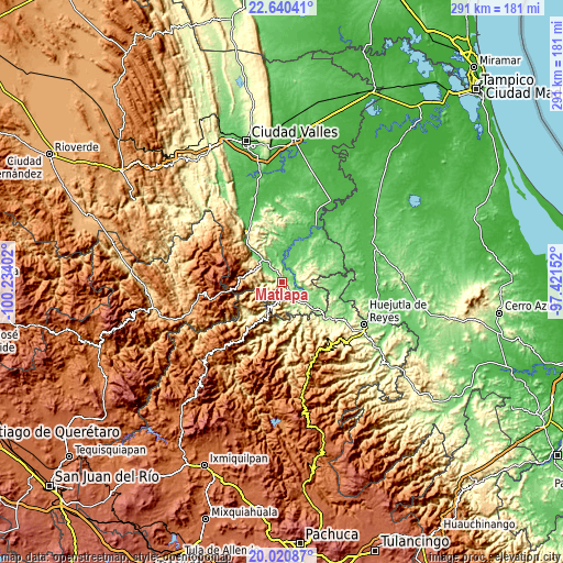
| \ | Map #1 | Map #2 | Topo.Map |
| Scale [m] | 98..961 m | 71..1296 m | × |
| Scale [ft] | 322..3153 ft | 233..4252 ft | × |
| Average | 288.3 m = 946 ft | 315.2 m = 1034 ft | × |
| Width | 9.1 km = 5.7 mi | 18.21 km = 11.3 mi | 291.3 km = 181 mi |
| Height | 9.1 km = 5.7 mi | 18.21 km = 11.3 mi | 291.3 km = 181 mi |
| ↑Max Latitude | 21.377418° | 21.418334° | 22.64041° |
| Latitude at center | 21.33649° | 21.33649° | 21.33649° |
| ↓Min Latitude | 21.295551° | 21.254601° | 20.02087° |
| ← Min Longitude | -98.871715° | -98.915661° | -100.23402° |
| Longitude center | -98.82777° | -98.82777° | -98.82777° |
| →Max Longitude | -98.783825° | -98.739879° | -97.42152° |
Nearby cities:
Cities around Matlapa sort by population:
• Tamazunchale elevation 131 m
9.4 km,  154°
154°
• Chalchocoyo 245 m
4.4 km,  123°
123°
• Jalpilla 115 m
8 km,  325°
325°
• Temalacaco 114 m
8.8 km,  347°
347°
• Picholco 112 m
6.3 km,  335°
335°
• Zapuyo 495 m
9.9 km,  281°
281°
• Chiconamel 252 m
11.8 km,  72°
72°
• Tenexio 141 m
7 km,  309°
309°
• Ahuehueyo Primero Centro 140 m
1.4 km, 314°
• Ocuiltzapoyo 140 m
10.4 km,  97°
97°
• San Francisco 1012 m
9.1 km,  225°
225°
• El Huexco 121 m
7.7 km,  86°
86°
Multilingual:
 En español:
Matlapa, Matlaca elevación 131 m.
 En France:
Matlapa élévation 131 m.


Sources and notes:
- [note 1] Map square and city borders are not equal. Map elevation data is calculated only from area inside that square.
- [src 1] Elevation data from geonames database provided with same terms of usage.
- [src 2] The elevation map of Matlapa is generated using elevation data from NASA's 3 arcsec (90m) resolution SRTM data.
- [src 3] Base (background) map © OpenStreetMap contributors tiles are generated by Geofabrik and OpenTopoMap.
Copyright & License:
This Matlapa Elevation Map is licensed under CC BY-SA. You may reuse any part from this page, if you give a proper credit by linking to this URL:
 More info on terms of use page.