Bel Air Rivière Sèche elevation
Bel Air Rivière Sèche (Flacq), Mauritius elevation is 78 meters and Bel Air Rivière Sèche elevation in feet is 256 ft above sea level [src 1]. Bel Air Rivière Sèche is a populated place (feature code) with elevation that is 71 meters (233 ft) smaller than average city elevation in Mauritius.
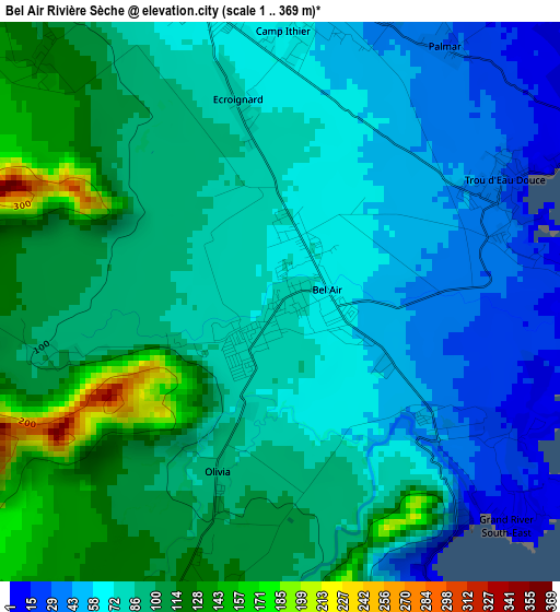
Below is the Elevation map of Bel Air Rivière Sèche, which displays elevation range with different colors. Scale of the first map is from 1 to 369 m (3 to 1211 ft) with average elevation of 84.3 meters (=277 ft) [note 1]
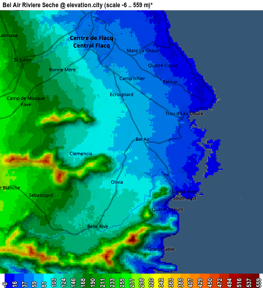
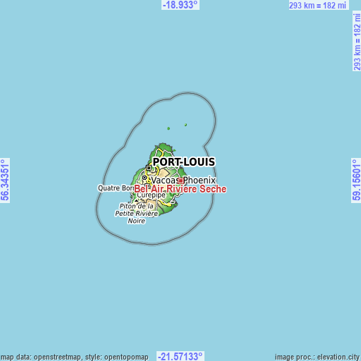
These maps also provides idea of topography and contour of this city, they are displayed at different zoom levels. More info about maps, scale and edge coordinates you can find below images.
| \ | Map #1 | Map #2 | Topo.Map |
| Scale [m] | 1..369 m | -6..559 m | × |
| Scale [ft] | 3..1211 ft | -20..1834 ft | × |
| Average | 84.3 m = 277 ft | 128.4 m = 421 ft | × |
| Width | 9.17 km = 5.7 mi | 18.34 km = 11.4 mi | 293.4 km = 182.3 mi |
| Height | 9.17 km = 5.7 mi | 18.34 km = 11.4 mi | 293.4 km = 182.3 mi |
| ↑Max Latitude | -20.216537° | -20.175294° | -18.933° |
| Latitude at center | -20.25777° | -20.25777° | -20.25777° |
| ↓Min Latitude | -20.298992° | -20.340202° | -21.57133° |
| ← Min Longitude | 57.705815° | 57.661869° | 56.34351° |
| Longitude center | 57.74976° | 57.74976° | 57.74976° |
| →Max Longitude | 57.793705° | 57.837651° | 59.15601° |
Nearby cities:
Cities around Bel Air Rivière Sèche sort by population:
• Centre de Flacq elevation 53 m
8.4 km,  334°
334°
• Ecroignard 81 m
3.8 km,  337°
337°
• Sebastopol 217 m
7.4 km,  240°
240°
• Quatre Cocos 8 m
6.8 km,  22°
22°
• Camp Ithier 63 m
4.7 km,  354°
354°
• Olivia 106 m
3.9 km,  210°
210°
• Quatre Soeurs 15 m
5.1 km,  154°
154°
• Queen Victoria 129 m
6.1 km,  313°
313°
• Grande Rivière Sud Est 47 m
4.2 km,  139°
139°
• Grand Sable 129 m
6.5 km,  166°
166°
• Mare La Chaux 50 m
6.6 km,  359°
359°
• Clémencia 108 m
4.6 km,  261°
261°
Multilingual:
 En español:
Bel Air Rivière Sèche elevación 78 m.
 En France:
Bel Air Rivière Sèche élévation 78 m.
 Auf Deutsch:
Bel Air Rivière Sèche höhe über dem Meeresspiegel ist 78 m.
 На русском:
Bel Air Rivière Sèche высота над уровнем моря 78 м
Sources and notes:
- [note 1] Map square and city borders are not equal. Map elevation data is calculated only from area inside that square.
- [src 1] Elevation data from geonames database provided with same terms of usage.
- [src 2] The elevation map of Bel Air Rivière Sèche is generated using elevation data from NASA's 3 arcsec (90m) resolution SRTM data.
- [src 3] Base (background) map © OpenStreetMap contributors tiles are generated by Geofabrik and OpenTopoMap.
Copyright & License:
This Bel Air Rivière Sèche Elevation Map is licensed under CC BY-SA. You may reuse any part from this page, if you give a proper credit by linking to this URL:
 More info on terms of use page.