Grande Rivière Noire elevation
Grande Rivière Noire (Black River), Mauritius elevation is 20 meters and Grande Rivière Noire elevation in feet is 66 ft above sea level [src 1]. Grande Rivière Noire is a populated place (feature code) with elevation that is 129 meters (423 ft) smaller than average city elevation in Mauritius.
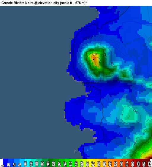
Below is the Elevation map of Grande Rivière Noire, which displays elevation range with different colors. Scale of the first map is from 0 to 678 m (0 to 2224 ft) with average elevation of 70.6 meters (=232 ft) [note 1]
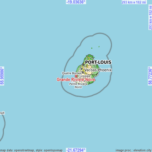
These maps also provides idea of topography and contour of this city, they are displayed at different zoom levels. More info about maps, scale and edge coordinates you can find below images.
| \ | Map #1 | Topo.Map |
| Scale [m] | 0..678 m | × |
| Scale [ft] | 0..2224 ft | × |
| Average | 70.6 m = 232 ft | × |
| Width | 9.16 km = 5.7 mi | 293.2 km = 182.2 mi |
| Height | 9.16 km = 5.7 mi | 293.2 km = 182.2 mi |
| ↑Max Latitude | -20.319075° | -19.03636° |
| Latitude at center | -20.36028° | -20.36028° |
| ↓Min Latitude | -20.401474° | -21.67294° |
| ← Min Longitude | 57.322165° | 55.95986° |
| Longitude center | 57.36611° | 57.36611° |
| →Max Longitude | 57.410055° | 58.77236° |
Nearby cities:
Cities around Grande Rivière Noire sort by population:
• Beau Bassin-Rose Hill elevation 249 m
17.6 km,  36°
36°
• Vacoas 390 m
13.6 km,  59°
59°
• Curepipe 382 m
17.4 km,  73°
73°
• Quatre Bornes 335 m
15.9 km,  47°
47°
• Bambous 122 m
12.3 km,  19°
19°
• Chemin Grenier 74 m
17.5 km,  143°
143°
• Chamouny 131 m
17.1 km, 142°
• Tamarin 1 m
3.9 km,  6°
6°
• Albion 145 m
17.5 km, 14°
• Cascavelle 135 m
9.2 km,  27°
27°
• Flic en Flac 15 m
9.6 km,  358°
358°
• Petite Case Noyale 12 m
3.6 km,  181°
181°
Multilingual:
 En español:
Grande Rivière Noire elevación 20 m.
 En France:
Grande Rivière Noire élévation 20 m.
 Auf Deutsch:
Grande Rivière Noire höhe über dem Meeresspiegel ist 20 m.
 На русском:
Grande Rivière Noire высота над уровнем моря 20 м
Sources and notes:
- [note 1] Map square and city borders are not equal. Map elevation data is calculated only from area inside that square.
- [src 1] Elevation data from geonames database provided with same terms of usage.
- [src 2] The elevation map of Grande Rivière Noire is generated using elevation data from NASA's 3 arcsec (90m) resolution SRTM data.
- [src 3] Base (background) map © OpenStreetMap contributors tiles are generated by Geofabrik and OpenTopoMap.
Copyright & License:
This Grande Rivière Noire Elevation Map is licensed under CC BY-SA. You may reuse any part from this page, if you give a proper credit by linking to this URL:
 More info on terms of use page.