Tamarin elevation
Tamarin (Black River), Mauritius elevation is 1 meters and Tamarin elevation in feet is 3 ft above sea level [src 1]. Tamarin is a seat of a first-order administrative division (feature code) with elevation that is 148 meters (486 ft) smaller than average city elevation in Mauritius.
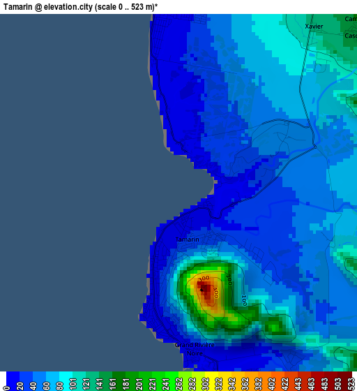
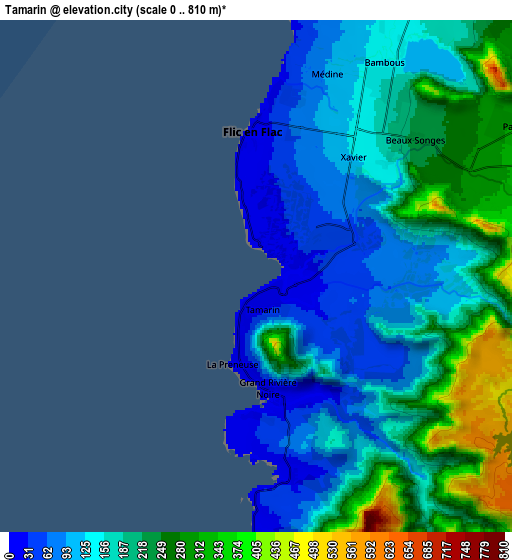
Below is the Elevation map of Tamarin, which displays elevation range with different colors. Scale of the first map is from 0 to 523 m (0 to 1716 ft) with average elevation of 61.8 meters (=203 ft) [note 1]
These maps also provides idea of topography and contour of this city, they are displayed at different zoom levels. More info about maps, scale and edge coordinates you can find below images.
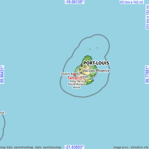
| \ | Map #1 | Map #2 | Topo.Map |
| Scale [m] | 0..523 m | 0..810 m | × |
| Scale [ft] | 0..1716 ft | 0..2657 ft | × |
| Average | 61.8 m = 203 ft | 182.7 m = 599 ft | × |
| Width | 9.16 km = 5.7 mi | 18.33 km = 11.4 mi | 293.2 km = 182.2 mi |
| Height | 9.16 km = 5.7 mi | 18.33 km = 11.4 mi | 293.2 km = 182.2 mi |
| ↑Max Latitude | -20.284345° | -20.24312° | -19.00135° |
| Latitude at center | -20.32556° | -20.32556° | -20.32556° |
| ↓Min Latitude | -20.366764° | -20.407956° | -21.63853° |
| ← Min Longitude | 57.326615° | 57.282669° | 55.96431° |
| Longitude center | 57.37056° | 57.37056° | 57.37056° |
| →Max Longitude | 57.414505° | 57.458451° | 58.77681° |
Nearby cities:
Cities around Tamarin sort by population:
• Beau Bassin-Rose Hill elevation 249 m
14.3 km,  44°
44°
• Vacoas 390 m
11.6 km,  74°
74°
• Curepipe 382 m
16.2 km,  86°
86°
• Quatre Bornes 335 m
13.2 km,  58°
58°
• Bambous 122 m
8.5 km,  25°
25°
• Gros Cailloux 71 m
14.5 km, 25°
• Albion 145 m
13.6 km,  16°
16°
• Cascavelle 135 m
5.7 km, 41°
• Grande Rivière Noire 20 m
3.9 km,  186°
186°
• Flic en Flac 15 m
5.8 km,  352°
352°
• Petite Case Noyale 12 m
7.5 km,  184°
184°
• Ebene 312 m
15.5 km,  54°
54°
Multilingual:
 En español:
Tamarin elevación 1 m.
 En France:
Tamarin élévation 1 m.


Sources and notes:
- [note 1] Map square and city borders are not equal. Map elevation data is calculated only from area inside that square.
- [src 1] Elevation data from geonames database provided with same terms of usage.
- [src 2] The elevation map of Tamarin is generated using elevation data from NASA's 3 arcsec (90m) resolution SRTM data.
- [src 3] Base (background) map © OpenStreetMap contributors tiles are generated by Geofabrik and OpenTopoMap.
Copyright & License:
This Tamarin Elevation Map is licensed under CC BY-SA. You may reuse any part from this page, if you give a proper credit by linking to this URL:
 More info on terms of use page.