Altan elevation
Altan (Dzabkhan), Mongolia elevation is 1913 meters and Altan elevation in feet is 6276 ft above sea level [src 1]. Altan is a seat of a second-order administrative division (feature code) with elevation that is 500 meters (1640 ft) bigger than average city elevation in Mongolia.
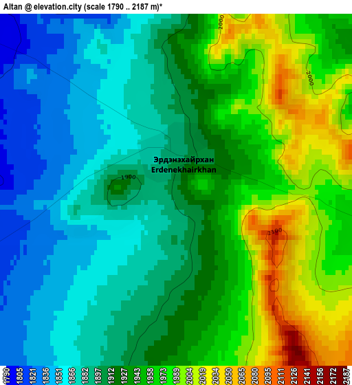
Below is the Elevation map of Altan, which displays elevation range with different colors. Scale of the first map is from 1790 to 2187 m (5873 to 7175 ft) with average elevation of 1922.8 meters (=6308 ft) [note 1]
These maps also provides idea of topography and contour of this city, they are displayed at different zoom levels. More info about maps, scale and edge coordinates you can find below images.
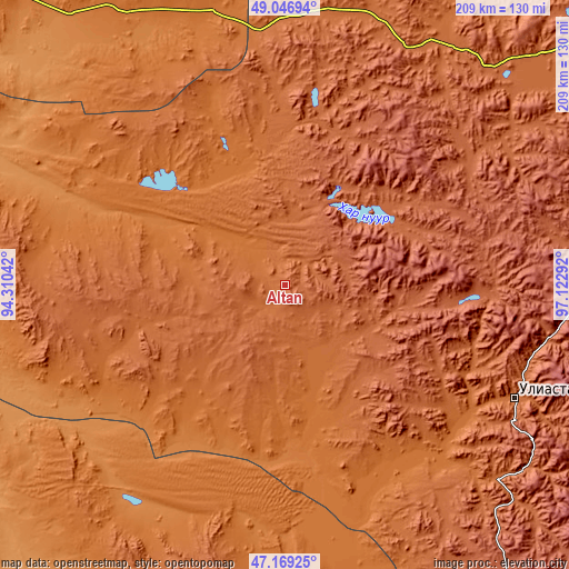
| \ | Map #1 | Topo.Map |
| Scale [m] | 1790..2187 m | × |
| Scale [ft] | 5873..7175 ft | × |
| Average | 1922.8 m = 6308 ft | × |
| Width | 6.52 km = 4.1 mi | 208.8 km = 129.7 mi |
| Height | 6.52 km = 4.1 mi | 208.8 km = 129.7 mi |
| ↑Max Latitude | 48.146° | 49.04694° |
| Latitude at center | 48.11667° | 48.11667° |
| ↓Min Latitude | 48.087323° | 47.16925° |
| ← Min Longitude | 95.672725° | 94.31042° |
| Longitude center | 95.71667° | 95.71667° |
| →Max Longitude | 95.760615° | 97.12292° |
Nearby cities:
Cities around Altan sort by population:
• Uliastay elevation 1755 m
93.8 km,  116°
116°
• Dzuunmod 1962 m
123.5 km,  84°
84°
• Sayn-Ust 1448 m
122.8 km,  226°
226°
• Hungiy 1269 m
114.2 km,  292°
292°
• Oygon 1766 m
114.2 km,  32°
32°
• Shiree 1828 m
106.4 km,  130°
130°
• Aldar 1649 m
80.8 km, 130°
• Buga 1396 m
74.5 km, 225°
• Tegsh 1948 m
73.6 km,  16°
16°
• Holboo 1568 m
56.5 km,  338°
338°
• Nuga 1443 m
49.7 km,  296°
296°
• Chandmanĭ 2113 m
40.3 km,  100°
100°
Multilingual:
 En español:
Altan elevación 1913 m.
 En France:
Altan élévation 1913 m.


Sources and notes:
- [note 1] Map square and city borders are not equal. Map elevation data is calculated only from area inside that square.
- [src 1] Elevation data from geonames database provided with same terms of usage.
- [src 2] The elevation map of Altan is generated using elevation data from NASA's 3 arcsec (90m) resolution SRTM data.
- [src 3] Base (background) map © OpenStreetMap contributors tiles are generated by Geofabrik and OpenTopoMap.
Copyright & License:
This Altan Elevation Map is licensed under CC BY-SA. You may reuse any part from this page, if you give a proper credit by linking to this URL:
 More info on terms of use page.