Tegsh elevation
Tegsh (Dzabkhan), Mongolia elevation is 1948 meters and Tegsh elevation in feet is 6391 ft above sea level [src 1]. Tegsh is a seat of a second-order administrative division (feature code) with elevation that is 535 meters (1755 ft) bigger than average city elevation in Mongolia.
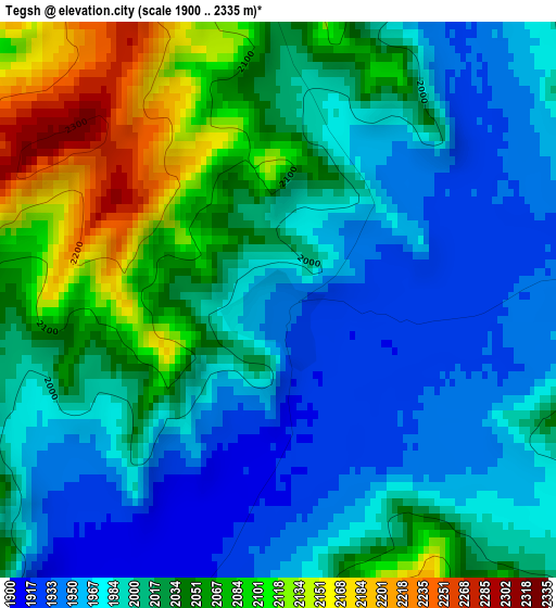
Below is the Elevation map of Tegsh, which displays elevation range with different colors. Scale of the first map is from 1900 to 2335 m (6234 to 7661 ft) with average elevation of 2013.3 meters (=6605 ft) [note 1]
These maps also provides idea of topography and contour of this city, they are displayed at different zoom levels. More info about maps, scale and edge coordinates you can find below images.
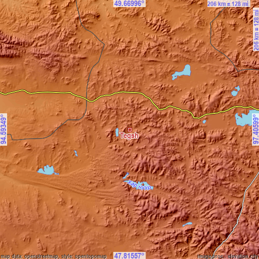
| \ | Map #1 | Topo.Map |
| Scale [m] | 1900..2335 m | × |
| Scale [ft] | 6234..7661 ft | × |
| Average | 2013.3 m = 6605 ft | × |
| Width | 6.44 km = 4 mi | 206.2 km = 128.1 mi |
| Height | 6.44 km = 4 mi | 206.2 km = 128.1 mi |
| ↑Max Latitude | 48.780286° | 49.66996° |
| Latitude at center | 48.75132° | 48.75132° |
| ↓Min Latitude | 48.722337° | 47.81557° |
| ← Min Longitude | 95.955795° | 94.59349° |
| Longitude center | 95.99974° | 95.99974° |
| →Max Longitude | 96.043685° | 97.40599° |
Nearby cities:
Cities around Tegsh sort by population:
• Altay elevation 1420 m
109 km,  13°
13°
• Asgat 1702 m
102.5 km,  34°
34°
• Dzür 1287 m
101.9 km,  351°
351°
• Tsetserleg 1870 m
101.3 km,  304°
304°
• Nuga 1443 m
81 km,  233°
233°
• Chandmanĭ 2113 m
80.1 km,  166°
166°
• Jargalant 1785 m
73.7 km,  326°
326°
• Altan 1913 m
73.6 km,  196°
196°
• Hödrögö 1850 m
71.8 km,  79°
79°
• Altanbulag 1871 m
66.6 km,  22°
22°
• Oygon 1766 m
47.5 km,  56°
56°
• Holboo 1568 m
45.4 km,  246°
246°
Multilingual:
 En español:
Tegsh elevación 1948 m.
 En France:
Tegsh élévation 1948 m.


Sources and notes:
- [note 1] Map square and city borders are not equal. Map elevation data is calculated only from area inside that square.
- [src 1] Elevation data from geonames database provided with same terms of usage.
- [src 2] The elevation map of Tegsh is generated using elevation data from NASA's 3 arcsec (90m) resolution SRTM data.
- [src 3] Base (background) map © OpenStreetMap contributors tiles are generated by Geofabrik and OpenTopoMap.
Copyright & License:
This Tegsh Elevation Map is licensed under CC BY-SA. You may reuse any part from this page, if you give a proper credit by linking to this URL:
 More info on terms of use page.