Altai elevation
Altai (Govĭ-Altay), Mongolia elevation is 2156 meters and Altai elevation in feet is 7073 ft above sea level [src 1]. Altai is a seat of a first-order administrative division (feature code) with elevation that is 743 meters (2438 ft) bigger than average city elevation in Mongolia.
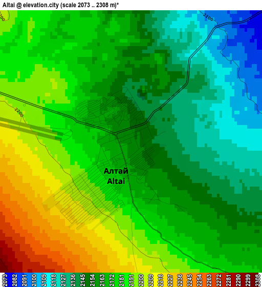
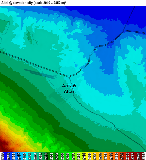
Below is the Elevation map of Altai, which displays elevation range with different colors. Scale of the first map is from 2073 to 2308 m (6801 to 7572 ft) with average elevation of 2170.8 meters (=7122 ft) [note 1]
These maps also provides idea of topography and contour of this city, they are displayed at different zoom levels. More info about maps, scale and edge coordinates you can find below images.
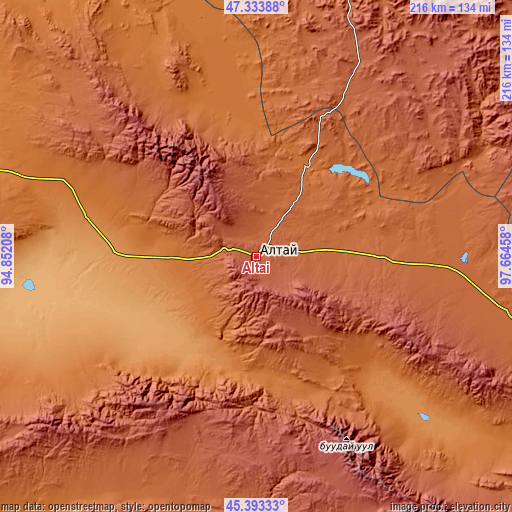
| \ | Map #1 | Map #2 | Topo.Map |
| Scale [m] | 2073..2308 m | 2010..2852 m | × |
| Scale [ft] | 6801..7572 ft | 6594..9357 ft | × |
| Average | 2170.8 m = 7122 ft | 2200.7 m = 7220 ft | × |
| Width | 6.74 km = 4.2 mi | 13.49 km = 8.4 mi | 215.8 km = 134.1 mi |
| Height | 6.74 km = 4.2 mi | 13.49 km = 8.4 mi | 215.8 km = 134.1 mi |
| ↑Max Latitude | 46.402533° | 46.432828° | 47.33388° |
| Latitude at center | 46.37222° | 46.37222° | 46.37222° |
| ↓Min Latitude | 46.341891° | 46.311544° | 45.39333° |
| ← Min Longitude | 96.214385° | 96.170439° | 94.85208° |
| Longitude center | 96.25833° | 96.25833° | 96.25833° |
| →Max Longitude | 96.302275° | 96.346221° | 97.66458° |
Nearby cities:
Cities around Altai sort by population:
• Tögrög elevation 1676 m
126.5 km,  241°
241°
• Tahilt 2300 m
117.9 km,  165°
165°
• Bayan 1848 m
106.2 km,  310°
310°
• Jargalant 1352 m
102.2 km,  136°
136°
• Tseel 2080 m
94.5 km,  198°
198°
• Balgatay 2398 m
89.9 km,  49°
49°
• Tsagaanchuluut 2149 m
88.1 km,  20°
20°
• Taygan 1797 m
85 km,  91°
91°
• Sharga 998 m
77.4 km,  259°
259°
• Buyanbat 1538 m
72 km,  339°
339°
• Haliun 1441 m
49.8 km,  188°
188°
• Tsagaan-Olom 1645 m
43.1 km,  28°
28°
Multilingual:
 En español:
Altai elevación 2156 m.
 En France:
Altai élévation 2156 m.


Sources and notes:
- [note 1] Map square and city borders are not equal. Map elevation data is calculated only from area inside that square.
- [src 1] Elevation data from geonames database provided with same terms of usage.
- [src 2] The elevation map of Altai is generated using elevation data from NASA's 3 arcsec (90m) resolution SRTM data.
- [src 3] Base (background) map © OpenStreetMap contributors tiles are generated by Geofabrik and OpenTopoMap.
Copyright & License:
This Altai Elevation Map is licensed under CC BY-SA. You may reuse any part from this page, if you give a proper credit by linking to this URL:
 More info on terms of use page.