Tsagaan-Olom elevation
Tsagaan-Olom (Govĭ-Altay), Mongolia elevation is 1645 meters and Tsagaan-Olom elevation in feet is 5397 ft above sea level [src 1]. Tsagaan-Olom is a seat of a second-order administrative division (feature code) with elevation that is 232 meters (761 ft) bigger than average city elevation in Mongolia.
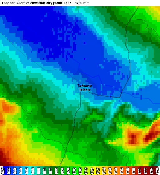
Below is the Elevation map of Tsagaan-Olom, which displays elevation range with different colors. Scale of the first map is from 1627 to 1790 m (5338 to 5873 ft) with average elevation of 1672.5 meters (=5487 ft) [note 1]
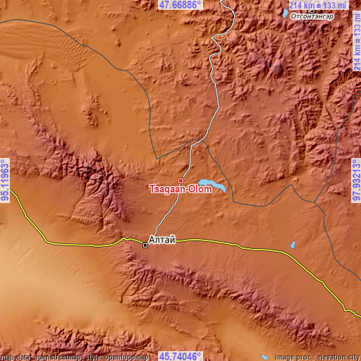
These maps also provides idea of topography and contour of this city, they are displayed at different zoom levels. More info about maps, scale and edge coordinates you can find below images.
| \ | Map #1 | Topo.Map |
| Scale [m] | 1627..1790 m | × |
| Scale [ft] | 5338..5873 ft | × |
| Average | 1672.5 m = 5487 ft | × |
| Width | 6.7 km = 4.2 mi | 214.4 km = 133.2 mi |
| Height | 6.7 km = 4.2 mi | 214.4 km = 133.2 mi |
| ↑Max Latitude | 46.743393° | 47.66886° |
| Latitude at center | 46.71327° | 46.71327° |
| ↓Min Latitude | 46.68313° | 45.74046° |
| ← Min Longitude | 96.481935° | 95.11963° |
| Longitude center | 96.52588° | 96.52588° |
| →Max Longitude | 96.569825° | 97.93213° |
Nearby cities:
Cities around Tsagaan-Olom sort by population:
• Uliastay elevation 1755 m
116.8 km,  11°
11°
• Altai 2156 m
43.1 km,  208°
208°
• Sharga 998 m
109.3 km,  241°
241°
• Bayan 1848 m
105.5 km,  287°
287°
• Aldar 1649 m
103.3 km,  0°
0°
• Buyant 2155 m
99 km,  55°
55°
• Haliun 1441 m
91.5 km,  197°
197°
• Shiree 1828 m
89.6 km, 13°
• Taygan 1797 m
75.7 km,  121°
121°
• Buyanbat 1538 m
54.4 km,  302°
302°
• Balgatay 2398 m
51.8 km,  66°
66°
• Tsagaanchuluut 2149 m
45.7 km, 14°
Multilingual:
 En español:
Tsagaan-Olom elevación 1645 m.
 En France:
Tsagaan-Olom élévation 1645 m.
 Auf Deutsch:
Tsagaan-Olom höhe über dem Meeresspiegel ist 1645 m.

Sources and notes:
- [note 1] Map square and city borders are not equal. Map elevation data is calculated only from area inside that square.
- [src 1] Elevation data from geonames database provided with same terms of usage.
- [src 2] The elevation map of Tsagaan-Olom is generated using elevation data from NASA's 3 arcsec (90m) resolution SRTM data.
- [src 3] Base (background) map © OpenStreetMap contributors tiles are generated by Geofabrik and OpenTopoMap.
Copyright & License:
This Tsagaan-Olom Elevation Map is licensed under CC BY-SA. You may reuse any part from this page, if you give a proper credit by linking to this URL:
 More info on terms of use page.