Baruunturuun elevation
Baruunturuun (Uvs), Mongolia elevation is 1234 meters and Baruunturuun elevation in feet is 4049 ft above sea level [src 1]. Baruunturuun is a seat of a second-order administrative division (feature code) with elevation that is 179 meters (587 ft) smaller than average city elevation in Mongolia.
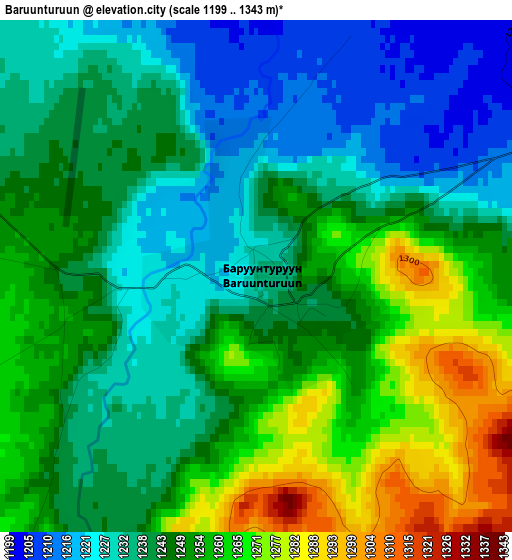
Below is the Elevation map of Baruunturuun, which displays elevation range with different colors. Scale of the first map is from 1199 to 1343 m (3934 to 4406 ft) with average elevation of 1246.1 meters (=4088 ft) [note 1]
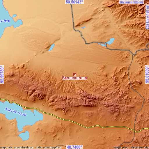
These maps also provides idea of topography and contour of this city, they are displayed at different zoom levels. More info about maps, scale and edge coordinates you can find below images.
| \ | Map #1 | Topo.Map |
| Scale [m] | 1199..1343 m | × |
| Scale [ft] | 3934..4406 ft | × |
| Average | 1246.1 m = 4088 ft | × |
| Width | 6.33 km = 3.9 mi | 202.4 km = 125.8 mi |
| Height | 6.33 km = 3.9 mi | 202.4 km = 125.8 mi |
| ↑Max Latitude | 49.688069° | 50.56143° |
| Latitude at center | 49.65963° | 49.65963° |
| ↓Min Latitude | 49.631175° | 48.7408° |
| ← Min Longitude | 94.360195° | 92.99789° |
| Longitude center | 94.40414° | 94.40414° |
| →Max Longitude | 94.448085° | 95.81039° |
Nearby cities:
Cities around Baruunturuun sort by population:
• Holboo elevation 1568 m
140.6 km,  147°
147°
• Naranbulag 1097 m
136.6 km,  256°
256°
• Sharbulag 1046 m
133.2 km,  225°
225°
• Hungiy 1269 m
127.3 km,  183°
183°
• Tooromt 795 m
107.2 km,  326°
326°
• Dzür 1287 m
100 km,  90°
90°
• Jargalant 1785 m
85 km,  117°
117°
• Tsalgar 1380 m
82.1 km,  274°
274°
• Tsetserleg 1870 m
54.2 km,  142°
142°
• Dzel 995 m
52.2 km,  301°
301°
• Bugat 1914 m
44.6 km,  251°
251°
• Tsagaanhayrhan 1804 m
31.4 km,  203°
203°
Multilingual:
 En español:
Baruunturuun elevación 1234 m.
 En France:
Baruunturuun élévation 1234 m.
 Auf Deutsch:
Baruunturuun höhe über dem Meeresspiegel ist 1234 m.

Sources and notes:
- [note 1] Map square and city borders are not equal. Map elevation data is calculated only from area inside that square.
- [src 1] Elevation data from geonames database provided with same terms of usage.
- [src 2] The elevation map of Baruunturuun is generated using elevation data from NASA's 3 arcsec (90m) resolution SRTM data.
- [src 3] Base (background) map © OpenStreetMap contributors tiles are generated by Geofabrik and OpenTopoMap.
Copyright & License:
This Baruunturuun Elevation Map is licensed under CC BY-SA. You may reuse any part from this page, if you give a proper credit by linking to this URL:
 More info on terms of use page.