Sharbulag elevation
Sharbulag (Uvs), Mongolia elevation is 1046 meters and Sharbulag elevation in feet is 3432 ft above sea level [src 1]. Sharbulag is a seat of a second-order administrative division (feature code) with elevation that is 367 meters (1204 ft) smaller than average city elevation in Mongolia.
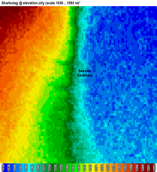
Below is the Elevation map of Sharbulag, which displays elevation range with different colors. Scale of the first map is from 1036 to 1093 m (3399 to 3586 ft) with average elevation of 1055.9 meters (=3464 ft) [note 1]
These maps also provides idea of topography and contour of this city, they are displayed at different zoom levels. More info about maps, scale and edge coordinates you can find below images.
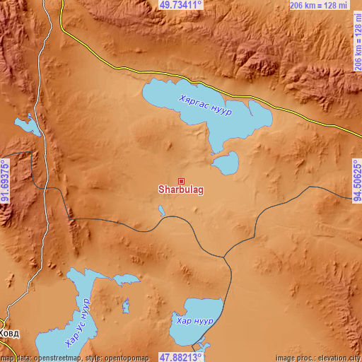
| \ | Map #1 | Topo.Map |
| Scale [m] | 1036..1093 m | × |
| Scale [ft] | 3399..3586 ft | × |
| Average | 1055.9 m = 3464 ft | × |
| Width | 6.43 km = 4 mi | 205.9 km = 127.9 mi |
| Height | 6.43 km = 4 mi | 205.9 km = 127.9 mi |
| ↑Max Latitude | 48.845598° | 49.73411° |
| Latitude at center | 48.81667° | 48.81667° |
| ↓Min Latitude | 48.787725° | 47.88213° |
| ← Min Longitude | 93.056055° | 91.69375° |
| Longitude center | 93.1° | 93.1° |
| →Max Longitude | 93.143945° | 94.50625° |
Nearby cities:
Cities around Sharbulag sort by population:
• Dzel elevation 995 m
131 km,  22°
22°
• Har-Us 1271 m
127.9 km,  253°
253°
• Buyant 1232 m
126.2 km,  228°
228°
• Urdgol 1520 m
114.3 km,  196°
196°
• Bayanhoshuu 1176 m
108.6 km, 233°
• Namir 1589 m
105.9 km,  287°
287°
• Tsagaanhayrhan 1804 m
104.9 km,  51°
51°
• Tsalgar 1380 m
100.8 km,  6°
6°
• Bugat 1914 m
95.2 km,  33°
33°
• Hungiy 1269 m
93.8 km,  110°
110°
• Har-Us 1581 m
81.6 km, 287°
• Naranbulag 1097 m
72.4 km,  327°
327°
Multilingual:
 En español:
Sharbulag elevación 1046 m.
 En France:
Sharbulag élévation 1046 m.
 Auf Deutsch:
Sharbulag höhe über dem Meeresspiegel ist 1046 m.

Sources and notes:
- [note 1] Map square and city borders are not equal. Map elevation data is calculated only from area inside that square.
- [src 1] Elevation data from geonames database provided with same terms of usage.
- [src 2] The elevation map of Sharbulag is generated using elevation data from NASA's 3 arcsec (90m) resolution SRTM data.
- [src 3] Base (background) map © OpenStreetMap contributors tiles are generated by Geofabrik and OpenTopoMap.
Copyright & License:
This Sharbulag Elevation Map is licensed under CC BY-SA. You may reuse any part from this page, if you give a proper credit by linking to this URL:
 More info on terms of use page.