Namir elevation
Namir (Uvs), Mongolia elevation is 1589 meters and Namir elevation in feet is 5213 ft above sea level [src 1]. Namir is a seat of a second-order administrative division (feature code) with elevation that is 176 meters (577 ft) bigger than average city elevation in Mongolia.
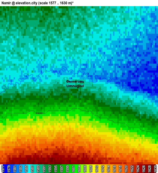
Below is the Elevation map of Namir, which displays elevation range with different colors. Scale of the first map is from 1577 to 1630 m (5174 to 5348 ft) with average elevation of 1595.9 meters (=5236 ft) [note 1]
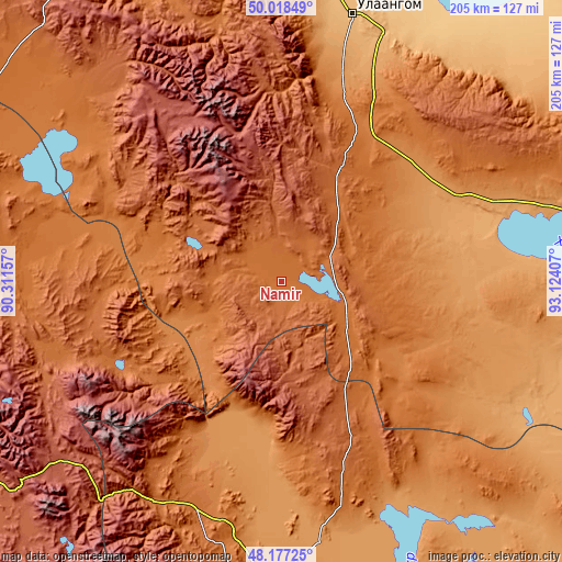
These maps also provides idea of topography and contour of this city, they are displayed at different zoom levels. More info about maps, scale and edge coordinates you can find below images.
| \ | Map #1 | Topo.Map |
| Scale [m] | 1577..1630 m | × |
| Scale [ft] | 5174..5348 ft | × |
| Average | 1595.9 m = 5236 ft | × |
| Width | 6.4 km = 4 mi | 204.7 km = 127.2 mi |
| Height | 6.4 km = 4 mi | 204.7 km = 127.2 mi |
| ↑Max Latitude | 49.135171° | 50.01849° |
| Latitude at center | 49.10641° | 49.10641° |
| ↓Min Latitude | 49.077633° | 48.17725° |
| ← Min Longitude | 91.673875° | 90.31157° |
| Longitude center | 91.71782° | 91.71782° |
| →Max Longitude | 91.761765° | 93.12407° |
Nearby cities:
Cities around Namir sort by population:
• Ulaangom elevation 935 m
100.5 km,  14°
14°
• Nogoonnuur 1484 m
121 km,  297°
297°
• Buyant 1232 m
115.8 km,  176°
176°
• Havtsal 1224 m
110.5 km,  358°
358°
• Sharbulag 1046 m
105.9 km,  107°
107°
• Bayanhoshuu 1176 m
98.2 km,  171°
171°
• Tsagaantüngi 1602 m
92.5 km,  266°
266°
• Harhiraa 1392 m
75.9 km, 10°
• Har-Us 1271 m
72.3 km,  196°
196°
• Naranbulag 1097 m
68.1 km,  64°
64°
• Höhtolgoy 1404 m
61.8 km,  288°
288°
• Har-Us 1581 m
24.4 km, 109°
Multilingual:
 En español:
Namir elevación 1589 m.
 En France:
Namir élévation 1589 m.


Sources and notes:
- [note 1] Map square and city borders are not equal. Map elevation data is calculated only from area inside that square.
- [src 1] Elevation data from geonames database provided with same terms of usage.
- [src 2] The elevation map of Namir is generated using elevation data from NASA's 3 arcsec (90m) resolution SRTM data.
- [src 3] Base (background) map © OpenStreetMap contributors tiles are generated by Geofabrik and OpenTopoMap.
Copyright & License:
This Namir Elevation Map is licensed under CC BY-SA. You may reuse any part from this page, if you give a proper credit by linking to this URL:
 More info on terms of use page.