Halban elevation
Halban (Hövsgöl), Mongolia elevation is 1752 meters and Halban elevation in feet is 5748 ft above sea level [src 1]. Halban is a seat of a second-order administrative division (feature code) with elevation that is 339 meters (1112 ft) bigger than average city elevation in Mongolia.
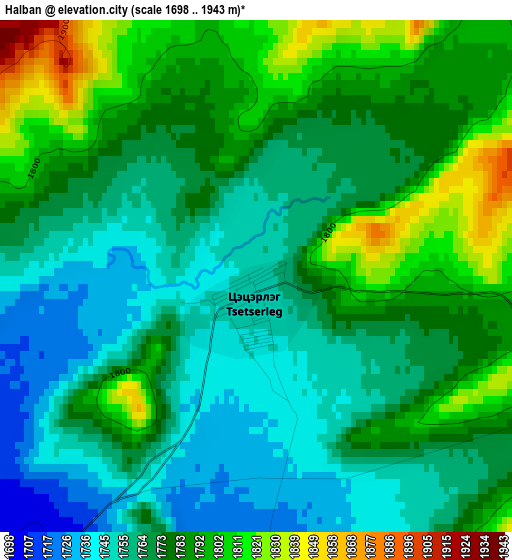
Below is the Elevation map of Halban, which displays elevation range with different colors. Scale of the first map is from 1698 to 1943 m (5571 to 6375 ft) with average elevation of 1774.6 meters (=5822 ft) [note 1]
These maps also provides idea of topography and contour of this city, they are displayed at different zoom levels. More info about maps, scale and edge coordinates you can find below images.
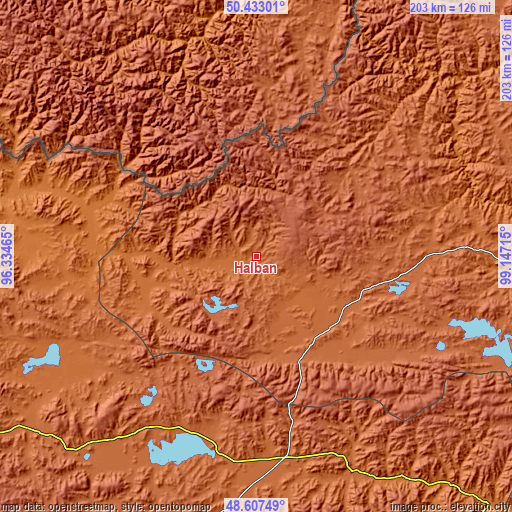
| \ | Map #1 | Topo.Map |
| Scale [m] | 1698..1943 m | × |
| Scale [ft] | 5571..6375 ft | × |
| Average | 1774.6 m = 5822 ft | × |
| Width | 6.34 km = 3.9 mi | 203 km = 126.1 mi |
| Height | 6.34 km = 3.9 mi | 203 km = 126.1 mi |
| ↑Max Latitude | 49.557285° | 50.43301° |
| Latitude at center | 49.52877° | 49.52877° |
| ↓Min Latitude | 49.500238° | 48.60749° |
| ← Min Longitude | 97.696955° | 96.33465° |
| Longitude center | 97.7409° | 97.7409° |
| →Max Longitude | 97.784845° | 99.14715° |
Nearby cities:
Cities around Halban sort by population:
• Tosontsengel elevation 1717 m
94.5 km,  155°
155°
• Bayan 1749 m
134.7 km,  94°
94°
• Mandal 1946 m
128.5 km,  71°
71°
• Bayan-Uhaa 1648 m
118.1 km,  139°
139°
• Altraga 1617 m
114.1 km,  50°
50°
• Oygon 1766 m
105.8 km,  235°
235°
• Altanbulag 1871 m
104.1 km,  256°
256°
• Altay 1420 m
101.4 km,  281°
281°
• Telmin Suma 1794 m
98.9 km,  185°
185°
• Hödrögö 1850 m
92.3 km,  217°
217°
• Sharga 2002 m
82 km, 68°
• Asgat 1702 m
68 km,  268°
268°
Multilingual:
 En español:
Halban elevación 1752 m.
 En France:
Halban élévation 1752 m.


Sources and notes:
- [note 1] Map square and city borders are not equal. Map elevation data is calculated only from area inside that square.
- [src 1] Elevation data from geonames database provided with same terms of usage.
- [src 2] The elevation map of Halban is generated using elevation data from NASA's 3 arcsec (90m) resolution SRTM data.
- [src 3] Base (background) map © OpenStreetMap contributors tiles are generated by Geofabrik and OpenTopoMap.
Copyright & License:
This Halban Elevation Map is licensed under CC BY-SA. You may reuse any part from this page, if you give a proper credit by linking to this URL:
 More info on terms of use page.