Tosontsengel elevation
Tosontsengel (Dzabkhan), Mongolia elevation is 1717 meters and Tosontsengel elevation in feet is 5633 ft above sea level [src 1]. Tosontsengel is a seat of a second-order administrative division (feature code) with elevation that is 304 meters (997 ft) bigger than average city elevation in Mongolia.
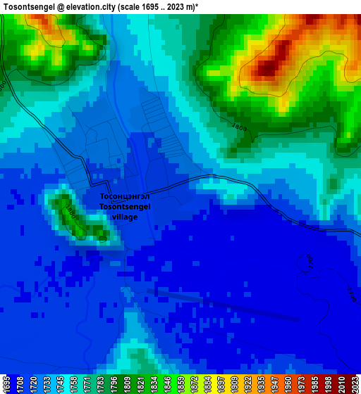
Below is the Elevation map of Tosontsengel, which displays elevation range with different colors. Scale of the first map is from 1695 to 2023 m (5561 to 6637 ft) with average elevation of 1751.3 meters (=5746 ft) [note 1]
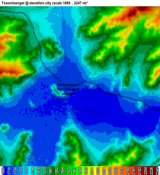
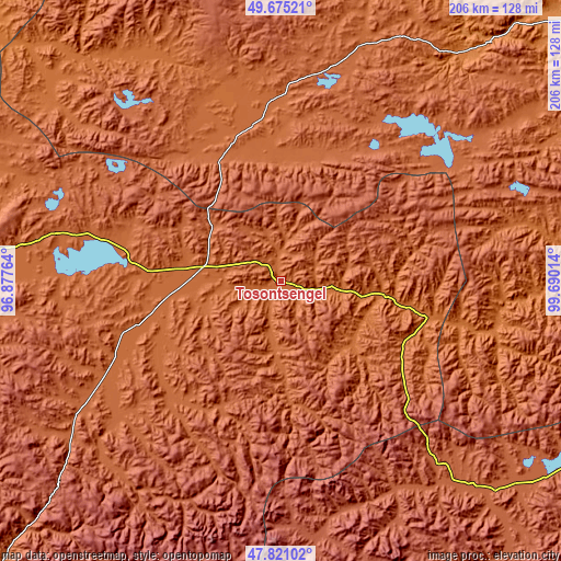
These maps also provides idea of topography and contour of this city, they are displayed at different zoom levels. More info about maps, scale and edge coordinates you can find below images.
| \ | Map #1 | Map #2 | Topo.Map |
| Scale [m] | 1695..2023 m | 1689..2247 m | × |
| Scale [ft] | 5561..6637 ft | 5541..7372 ft | × |
| Average | 1751.3 m = 5746 ft | 1814.8 m = 5954 ft | × |
| Width | 6.44 km = 4 mi | 12.89 km = 8 mi | 206.2 km = 128.1 mi |
| Height | 6.44 km = 4 mi | 12.89 km = 8 mi | 206.2 km = 128.1 mi |
| ↑Max Latitude | 48.785633° | 48.814579° | 49.67521° |
| Latitude at center | 48.75667° | 48.75667° | 48.75667° |
| ↓Min Latitude | 48.72769° | 48.698694° | 47.82102° |
| ← Min Longitude | 98.239945° | 98.195999° | 96.87764° |
| Longitude center | 98.28389° | 98.28389° | 98.28389° |
| →Max Longitude | 98.327835° | 98.371781° | 99.69014° |
Nearby cities:
Cities around Tosontsengel sort by population:
• Oygon elevation 1766 m
129.8 km,  281°
281°
• Sharga 2002 m
121.9 km,  17°
17°
• Bayan 1749 m
121.8 km,  51°
51°
• Ider 1487 m
116.5 km,  89°
89°
• Hödrögö 1850 m
97.6 km, 277°
• Halban 1752 m
94.5 km,  335°
335°
• Erdenet 1690 m
94.1 km,  76°
76°
• Dzuunmod 1962 m
89.7 km,  228°
228°
• Tsahir 2189 m
86.1 km,  150°
150°
• Orgil 1551 m
80.6 km,  103°
103°
• Telmin Suma 1794 m
50.4 km,  255°
255°
• Bayan-Uhaa 1648 m
37.5 km, 96°
Multilingual:
 En español:
Tosontsengel elevación 1717 m.
 En France:
Tosontsengel élévation 1717 m.
 Auf Deutsch:
Tosontsengel höhe über dem Meeresspiegel ist 1717 m.

Sources and notes:
- [note 1] Map square and city borders are not equal. Map elevation data is calculated only from area inside that square.
- [src 1] Elevation data from geonames database provided with same terms of usage.
- [src 2] The elevation map of Tosontsengel is generated using elevation data from NASA's 3 arcsec (90m) resolution SRTM data.
- [src 3] Base (background) map © OpenStreetMap contributors tiles are generated by Geofabrik and OpenTopoMap.
Copyright & License:
This Tosontsengel Elevation Map is licensed under CC BY-SA. You may reuse any part from this page, if you give a proper credit by linking to this URL:
 More info on terms of use page.