Erhet elevation
Erhet (Bulgan), Mongolia elevation is 1450 meters and Erhet elevation in feet is 4757 ft above sea level [src 1]. Erhet is a seat of a second-order administrative division (feature code) with elevation that is 37 meters (121 ft) bigger than average city elevation in Mongolia.
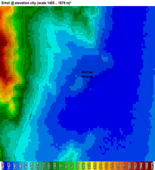
Below is the Elevation map of Erhet, which displays elevation range with different colors. Scale of the first map is from 1405 to 1878 m (4610 to 6161 ft) with average elevation of 1479.8 meters (=4855 ft) [note 1]
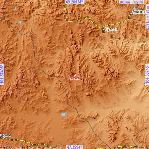
These maps also provides idea of topography and contour of this city, they are displayed at different zoom levels. More info about maps, scale and edge coordinates you can find below images.
| \ | Map #1 | Topo.Map |
| Scale [m] | 1405..1878 m | × |
| Scale [ft] | 4610..6161 ft | × |
| Average | 1479.8 m = 4855 ft | × |
| Width | 6.5 km = 4 mi | 208.1 km = 129.3 mi |
| Height | 6.5 km = 4 mi | 208.1 km = 129.3 mi |
| ↑Max Latitude | 48.30318° | 49.20134° |
| Latitude at center | 48.27394° | 48.27394° |
| ↓Min Latitude | 48.244683° | 47.3294° |
| ← Min Longitude | 102.937255° | 101.57495° |
| Longitude center | 102.9812° | 102.9812° |
| →Max Longitude | 103.025145° | 104.38745° |
Nearby cities:
Cities around Erhet sort by population:
• Bulgan elevation 1204 m
72.4 km,  34°
34°
• Bayan 1285 m
92.5 km,  172°
172°
• Dashinchilling 1016 m
92.4 km,  120°
120°
• Jargalant 1428 m
92.1 km,  234°
234°
• Uubulan 1352 m
85.7 km,  295°
295°
• Avdzaga 1137 m
81.6 km,  150°
150°
• Dzegstey 1349 m
74.6 km,  205°
205°
• Darhan 1265 m
66.6 km,  91°
91°
• Mandal 1074 m
56.7 km,  45°
45°
• Hüremt 1460 m
50.7 km,  328°
328°
• Höshööt 1300 m
36.9 km,  238°
238°
• Maanĭt 1306 m
33 km, 85°
Multilingual:
 En español:
Erhet elevación 1450 m.
 En France:
Erhet élévation 1450 m.


Sources and notes:
- [note 1] Map square and city borders are not equal. Map elevation data is calculated only from area inside that square.
- [src 1] Elevation data from geonames database provided with same terms of usage.
- [src 2] The elevation map of Erhet is generated using elevation data from NASA's 3 arcsec (90m) resolution SRTM data.
- [src 3] Base (background) map © OpenStreetMap contributors tiles are generated by Geofabrik and OpenTopoMap.
Copyright & License:
This Erhet Elevation Map is licensed under CC BY-SA. You may reuse any part from this page, if you give a proper credit by linking to this URL:
 More info on terms of use page.