Höshööt elevation
Höshööt (Arhangay), Mongolia elevation is 1300 meters and Höshööt elevation in feet is 4265 ft above sea level [src 1]. Höshööt is a seat of a second-order administrative division (feature code) with elevation that is 113 meters (371 ft) smaller than average city elevation in Mongolia.
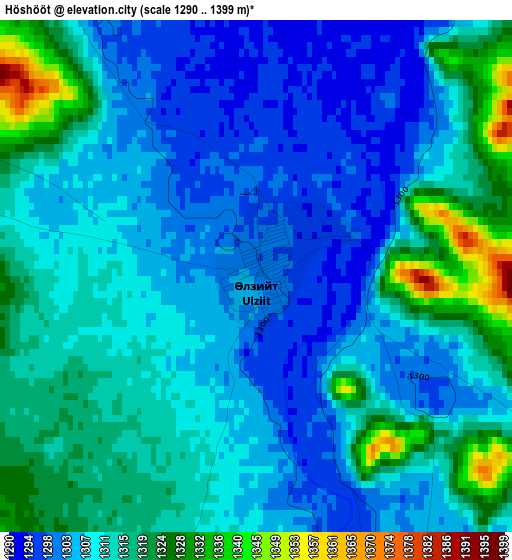
Below is the Elevation map of Höshööt, which displays elevation range with different colors. Scale of the first map is from 1290 to 1399 m (4232 to 4590 ft) with average elevation of 1310.8 meters (=4301 ft) [note 1]
These maps also provides idea of topography and contour of this city, they are displayed at different zoom levels. More info about maps, scale and edge coordinates you can find below images.
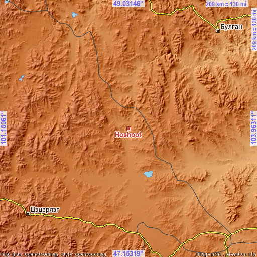
| \ | Map #1 | Topo.Map |
| Scale [m] | 1290..1399 m | × |
| Scale [ft] | 4232..4590 ft | × |
| Average | 1310.8 m = 4301 ft | × |
| Width | 6.53 km = 4.1 mi | 208.8 km = 129.7 mi |
| Height | 6.53 km = 4.1 mi | 208.8 km = 129.7 mi |
| ↑Max Latitude | 48.130239° | 49.03146° |
| Latitude at center | 48.1009° | 48.1009° |
| ↓Min Latitude | 48.071544° | 47.15319° |
| ← Min Longitude | 102.512915° | 101.15061° |
| Longitude center | 102.55686° | 102.55686° |
| →Max Longitude | 102.600805° | 103.96311° |
Nearby cities:
Cities around Höshööt sort by population:
• Altan-Ovoo elevation 1572 m
94.2 km,  219°
219°
• Tavanbulag 1627 m
93.5 km,  211°
211°
• Mandal 1074 m
92.9 km,  50°
50°
• Avdzaga 1137 m
88.5 km,  125°
125°
• Bayan 1285 m
84.9 km,  148°
148°
• Hotont 1456 m
82.3 km,  184°
184°
• Uubulan 1352 m
72.8 km,  320°
320°
• Maanĭt 1306 m
68 km,  71°
71°
• Hüremt 1460 m
62.7 km,  4°
4°
• Jargalant 1428 m
55.4 km,  231°
231°
• Dzegstey 1349 m
48.1 km, 180°
• Erhet 1450 m
36.9 km,  58°
58°
Multilingual:
 En español:
Höshööt elevación 1300 m.
 En France:
Höshööt élévation 1300 m.
 Auf Deutsch:
Höshööt höhe über dem Meeresspiegel ist 1300 m.

Sources and notes:
- [note 1] Map square and city borders are not equal. Map elevation data is calculated only from area inside that square.
- [src 1] Elevation data from geonames database provided with same terms of usage.
- [src 2] The elevation map of Höshööt is generated using elevation data from NASA's 3 arcsec (90m) resolution SRTM data.
- [src 3] Base (background) map © OpenStreetMap contributors tiles are generated by Geofabrik and OpenTopoMap.
Copyright & License:
This Höshööt Elevation Map is licensed under CC BY-SA. You may reuse any part from this page, if you give a proper credit by linking to this URL:
 More info on terms of use page.