Havirga elevation
Havirga (Sühbaatar), Mongolia elevation is 1090 meters and Havirga elevation in feet is 3576 ft above sea level [src 1]. Havirga is a seat of a second-order administrative division (feature code) with elevation that is 323 meters (1060 ft) smaller than average city elevation in Mongolia.
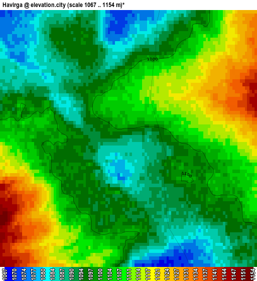
Below is the Elevation map of Havirga, which displays elevation range with different colors. Scale of the first map is from 1067 to 1154 m (3501 to 3786 ft) with average elevation of 1101.6 meters (=3614 ft) [note 1]
These maps also provides idea of topography and contour of this city, they are displayed at different zoom levels. More info about maps, scale and edge coordinates you can find below images.
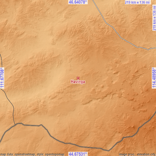
| \ | Map #1 | Topo.Map |
| Scale [m] | 1067..1154 m | × |
| Scale [ft] | 3501..3786 ft | × |
| Average | 1101.6 m = 3614 ft | × |
| Width | 6.83 km = 4.2 mi | 218.5 km = 135.8 mi |
| Height | 6.83 km = 4.2 mi | 218.5 km = 135.8 mi |
| ↑Max Latitude | 45.697372° | 46.64078° |
| Latitude at center | 45.66667° | 45.66667° |
| ↓Min Latitude | 45.635951° | 44.67531° |
| ← Min Longitude | 113.039385° | 111.67708° |
| Longitude center | 113.08333° | 113.08333° |
| →Max Longitude | 113.127275° | 114.48958° |
Nearby cities:
Cities around Havirga sort by population:
• Baruun-Urt elevation 991 m
113.7 km,  7°
7°
• Chonogol 1074 m
178.9 km,  81°
81°
• Bayasgalant 1242 m
166.5 km,  331°
331°
• Hongor 1077 m
146.9 km,  275°
275°
• Haylaastay 898 m
137.3 km,  26°
26°
• Sergelen 1102 m
114.5 km,  301°
301°
• Dzüünbulag 1020 m
105.7 km,  318°
318°
• Ulaandel 1049 m
86.4 km, 26°
• Hongor 1247 m
75.4 km,  141°
141°
• Ovoot 1244 m
72.1 km,  123°
123°
• Shireet 1096 m
56.9 km, 276°
• Hatavch 1047 m
56.5 km,  349°
349°
Multilingual:
 En español:
Havirga elevación 1090 m.
 En France:
Havirga élévation 1090 m.
 Auf Deutsch:
Havirga höhe über dem Meeresspiegel ist 1090 m.

Sources and notes:
- [note 1] Map square and city borders are not equal. Map elevation data is calculated only from area inside that square.
- [src 1] Elevation data from geonames database provided with same terms of usage.
- [src 2] The elevation map of Havirga is generated using elevation data from NASA's 3 arcsec (90m) resolution SRTM data.
- [src 3] Base (background) map © OpenStreetMap contributors tiles are generated by Geofabrik and OpenTopoMap.
Copyright & License:
This Havirga Elevation Map is licensed under CC BY-SA. You may reuse any part from this page, if you give a proper credit by linking to this URL:
 More info on terms of use page.