Bayasgalant elevation
Bayasgalant (Sühbaatar), Mongolia elevation is 1242 meters and Bayasgalant elevation in feet is 4075 ft above sea level [src 1]. Bayasgalant is a seat of a second-order administrative division (feature code) with elevation that is 171 meters (561 ft) smaller than average city elevation in Mongolia.
Below is the Elevation map of Bayasgalant, which displays elevation range with different colors. Scale of the first map is from 1179 to 1414 m (3868 to 4639 ft) with average elevation of 1250.4 meters (=4102 ft) [note 1]
These maps also provides idea of topography and contour of this city, they are displayed at different zoom levels. More info about maps, scale and edge coordinates you can find below images.
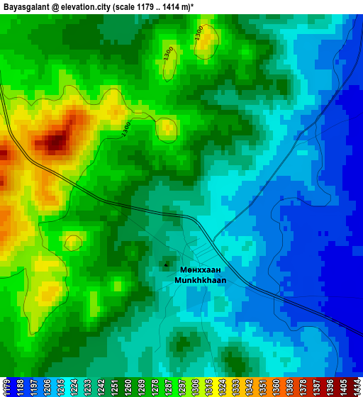
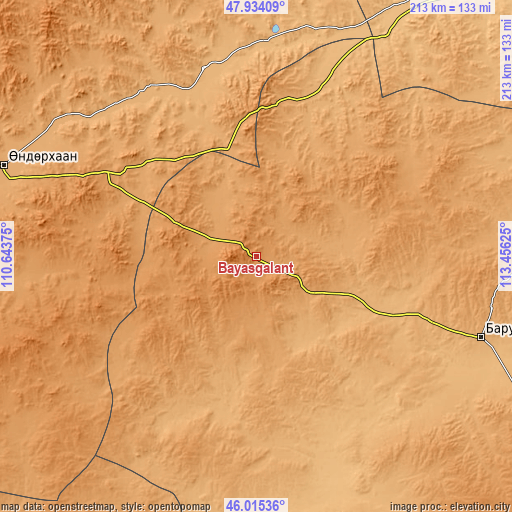
| \ | Map #1 | Topo.Map |
| Scale [m] | 1179..1414 m | × |
| Scale [ft] | 3868..4639 ft | × |
| Average | 1250.4 m = 4102 ft | × |
| Width | 6.67 km = 4.1 mi | 213.3 km = 132.5 mi |
| Height | 6.67 km = 4.1 mi | 213.3 km = 132.5 mi |
| ↑Max Latitude | 47.013302° | 47.93409° |
| Latitude at center | 46.98333° | 46.98333° |
| ↓Min Latitude | 46.953342° | 46.01536° |
| ← Min Longitude | 112.006055° | 110.64375° |
| Longitude center | 112.05° | 112.05° |
| →Max Longitude | 112.093945° | 113.45625° |
Nearby cities:
Cities around Bayasgalant sort by population:
• Baruun-Urt elevation 991 m
99.4 km,  109°
109°
• Undurkhaan 1030 m
111.9 km,  289°
289°
• Bayan 864 m
123.9 km,  33°
33°
• Buyant 1191 m
123.6 km,  228°
228°
• Herlen 1046 m
117.6 km, 287°
• Dundbürd 1040 m
114.8 km,  338°
338°
• Hatavch 1047 m
113.9 km,  142°
142°
• Bayan 1223 m
95.6 km,  282°
282°
• Javhlant 919 m
89.1 km,  3°
3°
• Sergelen 1102 m
88.9 km,  191°
191°
• Hanhöhiy 1139 m
70.7 km,  5°
5°
• Dzüünbulag 1020 m
67.5 km,  171°
171°
Multilingual:
 En español:
Bayasgalant elevación 1242 m.
 En France:
Bayasgalant élévation 1242 m.
 Auf Deutsch:
Bayasgalant höhe über dem Meeresspiegel ist 1242 m.

Sources and notes:
- [note 1] Map square and city borders are not equal. Map elevation data is calculated only from area inside that square.
- [src 1] Elevation data from geonames database provided with same terms of usage.
- [src 2] The elevation map of Bayasgalant is generated using elevation data from NASA's 3 arcsec (90m) resolution SRTM data.
- [src 3] Base (background) map © OpenStreetMap contributors tiles are generated by Geofabrik and OpenTopoMap.
Copyright & License:
This Bayasgalant Elevation Map is licensed under CC BY-SA. You may reuse any part from this page, if you give a proper credit by linking to this URL:
 More info on terms of use page.