Senj elevation
Senj (East Gobi Aymag), Mongolia elevation is 1004 meters and Senj elevation in feet is 3294 ft above sea level [src 1]. Senj is a seat of a second-order administrative division (feature code) with elevation that is 409 meters (1342 ft) smaller than average city elevation in Mongolia.
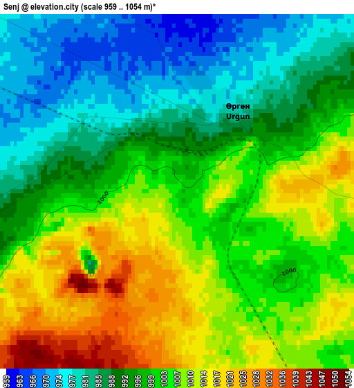
Below is the Elevation map of Senj, which displays elevation range with different colors. Scale of the first map is from 959 to 1054 m (3146 to 3458 ft) with average elevation of 999 meters (=3278 ft) [note 1]
These maps also provides idea of topography and contour of this city, they are displayed at different zoom levels. More info about maps, scale and edge coordinates you can find below images.
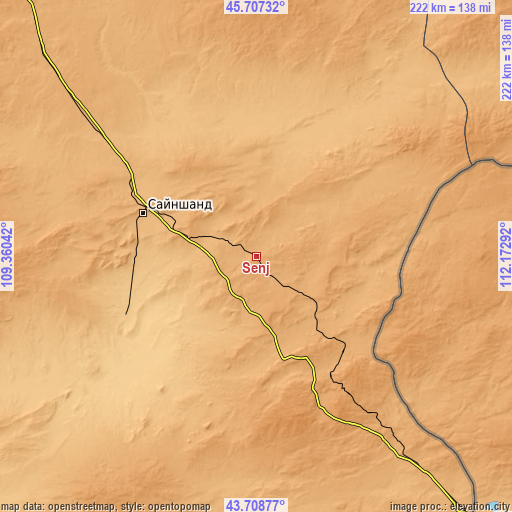
| \ | Map #1 | Topo.Map |
| Scale [m] | 959..1054 m | × |
| Scale [ft] | 3146..3458 ft | × |
| Average | 999 m = 3278 ft | × |
| Width | 6.94 km = 4.3 mi | 222.2 km = 138.1 mi |
| Height | 6.94 km = 4.3 mi | 222.2 km = 138.1 mi |
| ↑Max Latitude | 44.747889° | 45.70732° |
| Latitude at center | 44.71667° | 44.71667° |
| ↓Min Latitude | 44.685434° | 43.70877° |
| ← Min Longitude | 110.722725° | 109.36042° |
| Longitude center | 110.76667° | 110.76667° |
| →Max Longitude | 110.810615° | 112.17292° |
Nearby cities:
Cities around Senj sort by population:
• Saynshand elevation 947 m
54.5 km,  289°
289°
• Sergelen 1102 m
184.1 km,  26°
26°
• Bayan 1163 m
176.8 km,  344°
344°
• Buyant 1191 m
170.6 km,  1°
1°
• Shireet 1096 m
167.7 km,  47°
47°
• Tsagaandörvölj 1051 m
165.3 km,  316°
316°
• Khuvsget 996 m
152.8 km,  216°
216°
• Öldziyt 1245 m
138.4 km,  268°
268°
• Nüden 1015 m
128.3 km,  190°
190°
• Hongor 1077 m
125.1 km,  15°
15°
• Chandmanĭ 956 m
93.8 km,  345°
345°
• Ulaan-Uul 999 m
56.4 km,  139°
139°
Multilingual:
 En español:
Senj elevación 1004 m.
 En France:
Senj élévation 1004 m.


Sources and notes:
- [note 1] Map square and city borders are not equal. Map elevation data is calculated only from area inside that square.
- [src 1] Elevation data from geonames database provided with same terms of usage.
- [src 2] The elevation map of Senj is generated using elevation data from NASA's 3 arcsec (90m) resolution SRTM data.
- [src 3] Base (background) map © OpenStreetMap contributors tiles are generated by Geofabrik and OpenTopoMap.
Copyright & License:
This Senj Elevation Map is licensed under CC BY-SA. You may reuse any part from this page, if you give a proper credit by linking to this URL:
 More info on terms of use page.