Sümiyn Bulag elevation
Sümiyn Bulag (East Aimak), Mongolia elevation is 692 meters and Sümiyn Bulag elevation in feet is 2270 ft above sea level [src 1]. Sümiyn Bulag is a seat of a second-order administrative division (feature code) with elevation that is 721 meters (2365 ft) smaller than average city elevation in Mongolia.
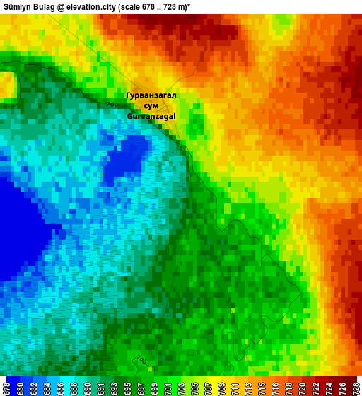
Below is the Elevation map of Sümiyn Bulag, which displays elevation range with different colors. Scale of the first map is from 678 to 728 m (2224 to 2388 ft) with average elevation of 701 meters (=2300 ft) [note 1]
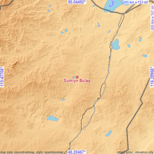
These maps also provides idea of topography and contour of this city, they are displayed at different zoom levels. More info about maps, scale and edge coordinates you can find below images.
| \ | Map #1 | Topo.Map |
| Scale [m] | 678..728 m | × |
| Scale [ft] | 2224..2388 ft | × |
| Average | 701 m = 2300 ft | × |
| Width | 6.39 km = 4 mi | 204.6 km = 127.1 mi |
| Height | 6.39 km = 4 mi | 204.6 km = 127.1 mi |
| ↑Max Latitude | 49.162075° | 50.04492° |
| Latitude at center | 49.13333° | 49.13333° |
| ↓Min Latitude | 49.104568° | 48.20467° |
| ← Min Longitude | 114.839385° | 113.47708° |
| Longitude center | 114.88333° | 114.88333° |
| →Max Longitude | 114.927275° | 116.28958° |
Nearby cities:
Cities around Sümiyn Bulag sort by population:
• Choibalsan elevation 741 m
120.7 km,  192°
192°
• Ereencav 620 m
103 km,  36°
36°
• Uldz 1036 m
216.8 km,  256°
256°
• Bayan 864 m
196.4 km,  226°
226°
• Javarthushuu 878 m
156.4 km,  270°
270°
• Öndörhoshuu 788 m
144.1 km,  209°
209°
• Tsagaan-Owoo 811 m
133.9 km, 232°
• Tsagaanders 752 m
126.3 km,  197°
197°
• Naranbulag 919 m
110.3 km,  276°
276°
• Sergelen 745 m
86 km,  222°
222°
• Hulstay 685 m
77.8 km,  180°
180°
• Dashbalbar 707 m
57.6 km,  322°
322°
Multilingual:
 En español:
Sümiyn Bulag elevación 692 m.
 En France:
Sümiyn Bulag élévation 692 m.
 Auf Deutsch:
Sümiyn Bulag höhe über dem Meeresspiegel ist 692 m.

Sources and notes:
- [note 1] Map square and city borders are not equal. Map elevation data is calculated only from area inside that square.
- [src 1] Elevation data from geonames database provided with same terms of usage.
- [src 2] The elevation map of Sümiyn Bulag is generated using elevation data from NASA's 3 arcsec (90m) resolution SRTM data.
- [src 3] Base (background) map © OpenStreetMap contributors tiles are generated by Geofabrik and OpenTopoMap.
Copyright & License:
This Sümiyn Bulag Elevation Map is licensed under CC BY-SA. You may reuse any part from this page, if you give a proper credit by linking to this URL:
 More info on terms of use page.