Uldz elevation
Uldz (Hentiy), Mongolia elevation is 1036 meters and Uldz elevation in feet is 3399 ft above sea level [src 1]. Uldz is a seat of a second-order administrative division (feature code) with elevation that is 377 meters (1237 ft) smaller than average city elevation in Mongolia.
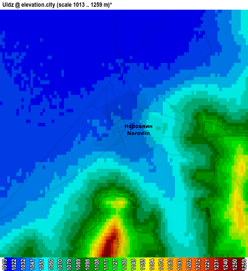
Below is the Elevation map of Uldz, which displays elevation range with different colors. Scale of the first map is from 1013 to 1259 m (3323 to 4131 ft) with average elevation of 1054.4 meters (=3459 ft) [note 1]
These maps also provides idea of topography and contour of this city, they are displayed at different zoom levels. More info about maps, scale and edge coordinates you can find below images.
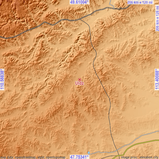
| \ | Map #1 | Topo.Map |
| Scale [m] | 1013..1259 m | × |
| Scale [ft] | 3323..4131 ft | × |
| Average | 1054.4 m = 3459 ft | × |
| Width | 6.45 km = 4 mi | 206.4 km = 128.3 mi |
| Height | 6.45 km = 4 mi | 206.4 km = 128.3 mi |
| ↑Max Latitude | 48.719281° | 49.61004° |
| Latitude at center | 48.69028° | 48.69028° |
| ↓Min Latitude | 48.661262° | 47.75341° |
| ← Min Longitude | 111.950685° | 110.58838° |
| Longitude center | 111.99463° | 111.99463° |
| →Max Longitude | 112.038575° | 113.40088° |
Nearby cities:
Cities around Uldz sort by population:
• Sergelen elevation 745 m
154.1 km,  95°
95°
• Eg 1107 m
133 km,  269°
269°
• Hanhöhiy 1139 m
119.8 km,  175°
175°
• Naranbulag 919 m
118 km,  58°
58°
• Bayan 864 m
111.3 km,  140°
140°
• Tsagaan-Owoo 811 m
110.7 km,  106°
106°
• Onon 1053 m
102.8 km, 265°
• Javhlant 919 m
101.2 km,  174°
174°
• Dundbürd 1040 m
90.6 km,  203°
203°
• Javarthushuu 878 m
74.3 km,  46°
46°
• Bayan 1050 m
68.8 km,  256°
256°
• Bayan-Ovoo 957 m
44.9 km,  323°
323°
Multilingual:
 En español:
Uldz elevación 1036 m.
 En France:
Uldz élévation 1036 m.


Sources and notes:
- [note 1] Map square and city borders are not equal. Map elevation data is calculated only from area inside that square.
- [src 1] Elevation data from geonames database provided with same terms of usage.
- [src 2] The elevation map of Uldz is generated using elevation data from NASA's 3 arcsec (90m) resolution SRTM data.
- [src 3] Base (background) map © OpenStreetMap contributors tiles are generated by Geofabrik and OpenTopoMap.
Copyright & License:
This Uldz Elevation Map is licensed under CC BY-SA. You may reuse any part from this page, if you give a proper credit by linking to this URL:
 More info on terms of use page.