Tsetserleg elevation
Tsetserleg (Arhangay), Mongolia elevation is 1705 meters and Tsetserleg elevation in feet is 5594 ft above sea level [src 1]. Tsetserleg is a seat of a first-order administrative division (feature code) with elevation that is 292 meters (958 ft) bigger than average city elevation in Mongolia.
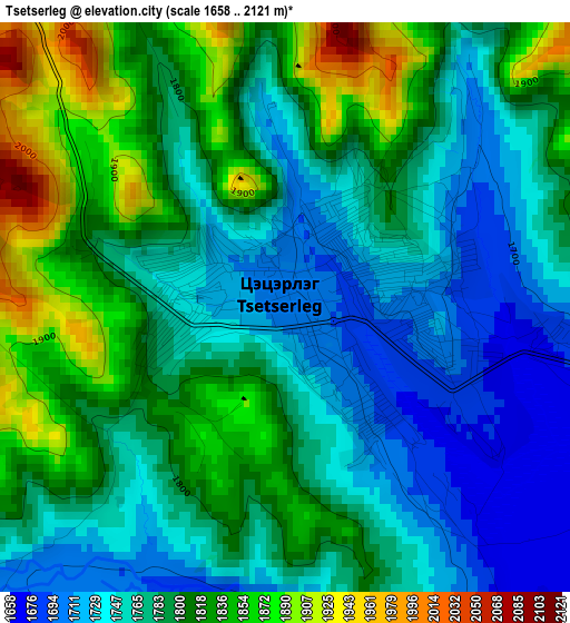
Below is the Elevation map of Tsetserleg, which displays elevation range with different colors. Scale of the first map is from 1658 to 2121 m (5440 to 6959 ft) with average elevation of 1788.3 meters (=5867 ft) [note 1]
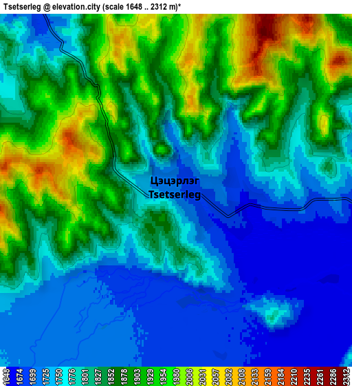
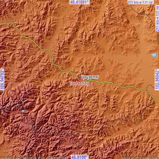
These maps also provides idea of topography and contour of this city, they are displayed at different zoom levels. More info about maps, scale and edge coordinates you can find below images.
| \ | Map #1 | Map #2 | Topo.Map |
| Scale [m] | 1658..2121 m | 1648..2312 m | × |
| Scale [ft] | 5440..6959 ft | 5407..7585 ft | × |
| Average | 1788.3 m = 5867 ft | 1818.6 m = 5967 ft | × |
| Width | 6.61 km = 4.1 mi | 13.21 km = 8.2 mi | 211.4 km = 131.4 mi |
| Height | 6.61 km = 4.1 mi | 13.21 km = 8.2 mi | 211.4 km = 131.4 mi |
| ↑Max Latitude | 47.504695° | 47.534373° | 48.41691° |
| Latitude at center | 47.475° | 47.475° | 47.475° |
| ↓Min Latitude | 47.445288° | 47.41556° | 46.5159° |
| ← Min Longitude | 101.410225° | 101.366279° | 100.04792° |
| Longitude center | 101.45417° | 101.45417° | 101.45417° |
| →Max Longitude | 101.498115° | 101.542061° | 102.86042° |
Nearby cities:
Cities around Tsetserleg sort by population:
• Harhorin elevation 1471 m
107.7 km,  106°
106°
• Kharkhorin 1476 m
107.1 km, 107°
• Teel 1935 m
95 km,  311°
311°
• Övt 1681 m
94.8 km,  140°
140°
• Jargalant 2033 m
93.2 km,  273°
273°
• Dzegstey 1349 m
85 km,  75°
75°
• Hotont 1456 m
77.3 km,  99°
99°
• Jargalant 1428 m
52.5 km,  47°
47°
• Dzaanhoshuu 1765 m
43.3 km, 272°
• Tavanbulag 1627 m
35.7 km, 106°
• Bulagiyn Denj 1909 m
30.8 km,  235°
235°
• Altan-Ovoo 1572 m
22.8 km, 97°
Multilingual:
 En español:
Tsetserleg elevación 1705 m.
 En France:
Tsetserleg élévation 1705 m.
 Auf Deutsch:
Tsetserleg höhe über dem Meeresspiegel ist 1705 m.

Sources and notes:
- [note 1] Map square and city borders are not equal. Map elevation data is calculated only from area inside that square.
- [src 1] Elevation data from geonames database provided with same terms of usage.
- [src 2] The elevation map of Tsetserleg is generated using elevation data from NASA's 3 arcsec (90m) resolution SRTM data.
- [src 3] Base (background) map © OpenStreetMap contributors tiles are generated by Geofabrik and OpenTopoMap.
Copyright & License:
This Tsetserleg Elevation Map is licensed under CC BY-SA. You may reuse any part from this page, if you give a proper credit by linking to this URL:
 More info on terms of use page.