Harhorin elevation
Harhorin (Övörhangay), Mongolia elevation is 1471 meters and Harhorin elevation in feet is 4826 ft above sea level [src 1]. Harhorin is a seat of a second-order administrative division (feature code) with elevation that is 58 meters (190 ft) bigger than average city elevation in Mongolia.
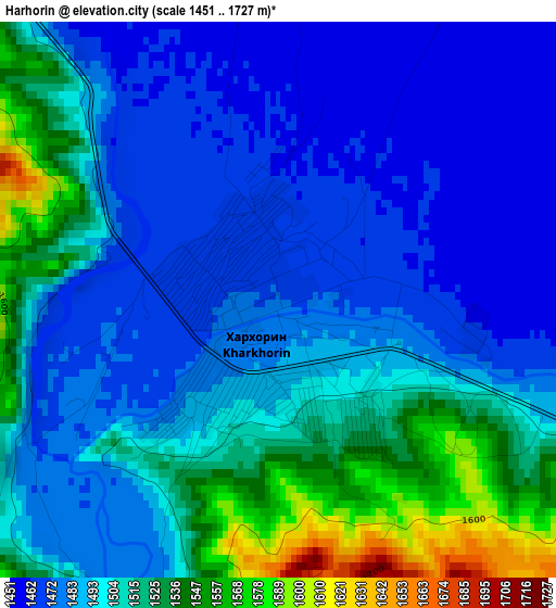
Below is the Elevation map of Harhorin, which displays elevation range with different colors. Scale of the first map is from 1451 to 1727 m (4760 to 5666 ft) with average elevation of 1498.3 meters (=4916 ft) [note 1]
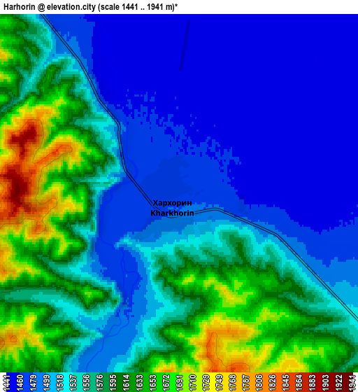
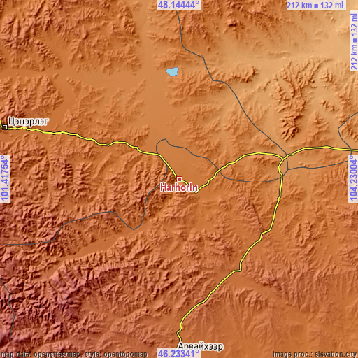
These maps also provides idea of topography and contour of this city, they are displayed at different zoom levels. More info about maps, scale and edge coordinates you can find below images.
| \ | Map #1 | Map #2 | Topo.Map |
| Scale [m] | 1451..1727 m | 1441..1941 m | × |
| Scale [ft] | 4760..5666 ft | 4728..6368 ft | × |
| Average | 1498.3 m = 4916 ft | 1548.1 m = 5079 ft | × |
| Width | 6.64 km = 4.1 mi | 13.28 km = 8.3 mi | 212.5 km = 132 mi |
| Height | 6.64 km = 4.1 mi | 13.28 km = 8.3 mi | 212.5 km = 132 mi |
| ↑Max Latitude | 47.227381° | 47.257216° | 48.14444° |
| Latitude at center | 47.19753° | 47.19753° | 47.19753° |
| ↓Min Latitude | 47.167662° | 47.137777° | 46.23341° |
| ← Min Longitude | 102.779845° | 102.735899° | 101.41754° |
| Longitude center | 102.82379° | 102.82379° | 102.82379° |
| →Max Longitude | 102.867735° | 102.911681° | 104.23004° |
Nearby cities:
Cities around Harhorin sort by population:
• Kharkhorin elevation 1476 m
1 km,  234°
234°
• Bayan-Ulaan 1870 m
77.1 km,  193°
193°
• Ongon 1491 m
76.5 km,  108°
108°
• Mönhbulag 1797 m
72.4 km,  133°
133°
• Tavanbulag 1627 m
72 km,  286°
286°
• Sangiyn Dalay 1705 m
71.5 km,  148°
148°
• Avdzaga 1137 m
71.2 km,  47°
47°
• Övt 1681 m
60.7 km, 225°
• Dzegstey 1349 m
56.2 km,  338°
338°
• Bayan 1285 m
37.3 km,  41°
41°
• Khujirt 1658 m
33.7 km, 187°
• Hotont 1456 m
32.5 km,  304°
304°
Multilingual:
 En español:
Harhorin elevación 1471 m.
 En France:
Harhorin élévation 1471 m.
 Auf Deutsch:
Harhorin höhe über dem Meeresspiegel ist 1471 m.

Sources and notes:
- [note 1] Map square and city borders are not equal. Map elevation data is calculated only from area inside that square.
- [src 1] Elevation data from geonames database provided with same terms of usage.
- [src 2] The elevation map of Harhorin is generated using elevation data from NASA's 3 arcsec (90m) resolution SRTM data.
- [src 3] Base (background) map © OpenStreetMap contributors tiles are generated by Geofabrik and OpenTopoMap.
Copyright & License:
This Harhorin Elevation Map is licensed under CC BY-SA. You may reuse any part from this page, if you give a proper credit by linking to this URL:
 More info on terms of use page.