Djénné elevation
Djénné (Mopti), Mali elevation is 278 meters and Djénné elevation in feet is 912 ft above sea level [src 1]. Djénné is a populated place (feature code) with elevation that is 30 meters (98 ft) smaller than average city elevation in Mali.
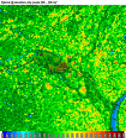
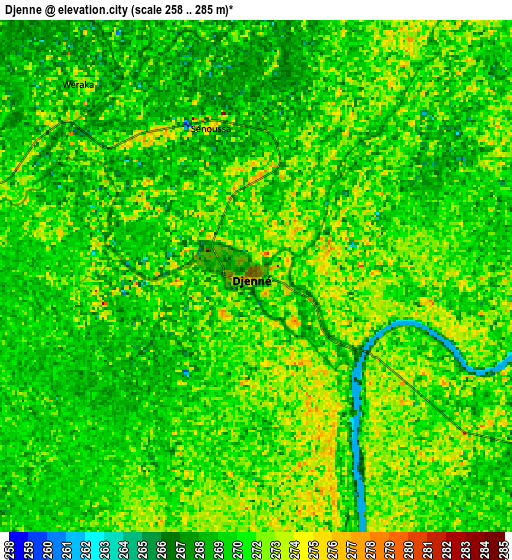
Below is the Elevation map of Djénné, which displays elevation range with different colors. Scale of the first map is from 260 to 284 m (853 to 932 ft) with average elevation of 271.1 meters (=889 ft) [note 1]
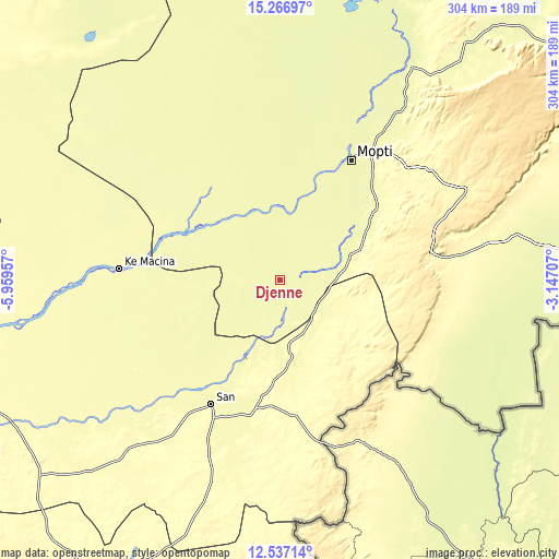
These maps also provides idea of topography and contour of this city, they are displayed at different zoom levels. More info about maps, scale and edge coordinates you can find below images.
| \ | Map #1 | Map #2 | Topo.Map |
| Scale [m] | 260..284 m | 258..285 m | × |
| Scale [ft] | 853..932 ft | 846..935 ft | × |
| Average | 271.1 m = 889 ft | 270.7 m = 888 ft | × |
| Width | 9.49 km = 5.9 mi | 18.97 km = 11.8 mi | 303.5 km = 188.6 mi |
| Height | 9.49 km = 5.9 mi | 18.97 km = 11.8 mi | 303.6 km = 188.6 mi |
| ↑Max Latitude | 13.948733° | 13.991379° | 15.26697° |
| Latitude at center | 13.90608° | 13.90608° | 13.90608° |
| ↓Min Latitude | 13.863419° | 13.82075° | 12.53714° |
| ← Min Longitude | -4.597265° | -4.641211° | -5.95957° |
| Longitude center | -4.55332° | -4.55332° | -4.55332° |
| →Max Longitude | -4.509375° | -4.465429° | -3.14707° |
Nearby cities:
Cities around Djénné sort by population:
• Mopti elevation 268 m
75.7 km,  31°
31°
• Markala 292 m
164.9 km,  262°
262°
• San 285 m
76.5 km,  208°
208°
• Ké-Macina 283 m
87.1 km,  274°
274°
• Ténenkou 273 m
72.7 km,  327°
327°
• Bandiagara 388 m
113 km,  64°
64°
• Kinmparana 306 m
124.9 km,  198°
198°
• Youwarou 268 m
165.6 km,  10°
10°
• Koro 260 m
160.4 km,  83°
83°
• Niono 290 m
160 km,  283°
283°
• Bankass 301 m
113.5 km, 80°
• Tominian 301 m
68.9 km,  183°
183°
Multilingual:
 En español:
Djénné elevación 278 m.
 En France:
Djénné élévation 278 m.


Sources and notes:
- [note 1] Map square and city borders are not equal. Map elevation data is calculated only from area inside that square.
- [src 1] Elevation data from geonames database provided with same terms of usage.
- [src 2] The elevation map of Djénné is generated using elevation data from NASA's 3 arcsec (90m) resolution SRTM data.
- [src 3] Base (background) map © OpenStreetMap contributors tiles are generated by Geofabrik and OpenTopoMap.
Copyright & License:
This Djénné Elevation Map is licensed under CC BY-SA. You may reuse any part from this page, if you give a proper credit by linking to this URL:
 More info on terms of use page.