Ténenkou elevation
Ténenkou (Mopti), Mali elevation is 273 meters and Ténenkou elevation in feet is 896 ft above sea level [src 1]. Ténenkou is a seat of a second-order administrative division (feature code) with elevation that is 35 meters (115 ft) smaller than average city elevation in Mali.
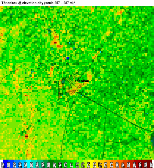
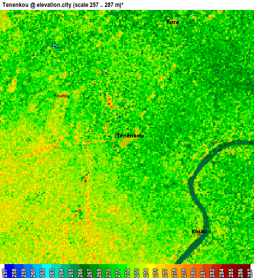
Below is the Elevation map of Ténenkou, which displays elevation range with different colors. Scale of the first map is from 257 to 287 m (843 to 942 ft) with average elevation of 271.3 meters (=890 ft) [note 1]
These maps also provides idea of topography and contour of this city, they are displayed at different zoom levels. More info about maps, scale and edge coordinates you can find below images.
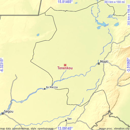
| \ | Map #1 | Map #2 | Topo.Map |
| Scale [m] | 257..287 m | 257..287 m | × |
| Scale [ft] | 843..942 ft | 843..942 ft | × |
| Average | 271.3 m = 890 ft | 271.5 m = 891 ft | × |
| Width | 9.46 km = 5.9 mi | 18.93 km = 11.8 mi | 302.8 km = 188.2 mi |
| Height | 9.46 km = 5.9 mi | 18.93 km = 11.8 mi | 302.8 km = 188.2 mi |
| ↑Max Latitude | 14.49977° | 14.542311° | 15.81465° |
| Latitude at center | 14.45722° | 14.45722° | 14.45722° |
| ↓Min Latitude | 14.414662° | 14.372096° | 13.09145° |
| ← Min Longitude | -4.960845° | -5.004791° | -6.32315° |
| Longitude center | -4.9169° | -4.9169° | -4.9169° |
| →Max Longitude | -4.872955° | -4.829009° | -3.51065° |
Nearby cities:
Cities around Ténenkou sort by population:
• Mopti elevation 268 m
79.1 km,  87°
87°
• Markala 292 m
149.7 km,  235°
235°
• San 285 m
128.3 km,  178°
178°
• Djénné 278 m
72.7 km,  147°
147°
• Ké-Macina 283 m
72.6 km,  220°
220°
• Bandiagara 388 m
141.2 km, 94°
• Kinmparana 306 m
179.6 km, 180°
• Sokolo 274 m
133.2 km,  283°
283°
• Bankass 301 m
156.8 km,  105°
105°
• Tominian 301 m
134.7 km,  164°
164°
• Youwarou 268 m
123.3 km,  34°
34°
• Niono 290 m
118.1 km,  258°
258°
Multilingual:
 En español:
Ténenkou elevación 273 m.
 En France:
Ténenkou élévation 273 m.
 Auf Deutsch:
Ténenkou höhe über dem Meeresspiegel ist 273 m.

Sources and notes:
- [note 1] Map square and city borders are not equal. Map elevation data is calculated only from area inside that square.
- [src 1] Elevation data from geonames database provided with same terms of usage.
- [src 2] The elevation map of Ténenkou is generated using elevation data from NASA's 3 arcsec (90m) resolution SRTM data.
- [src 3] Base (background) map © OpenStreetMap contributors tiles are generated by Geofabrik and OpenTopoMap.
Copyright & License:
This Ténenkou Elevation Map is licensed under CC BY-SA. You may reuse any part from this page, if you give a proper credit by linking to this URL:
 More info on terms of use page.