Sagalo elevation
Sagalo (Kayes), Mali elevation is 540 meters and Sagalo elevation in feet is 1772 ft above sea level [src 1]. Sagalo is a populated place (feature code) with elevation that is 232 meters (761 ft) bigger than average city elevation in Mali.
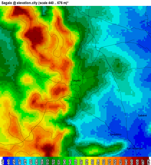
Below is the Elevation map of Sagalo, which displays elevation range with different colors. Scale of the first map is from 440 to 676 m (1444 to 2218 ft) with average elevation of 531 meters (=1742 ft) [note 1]
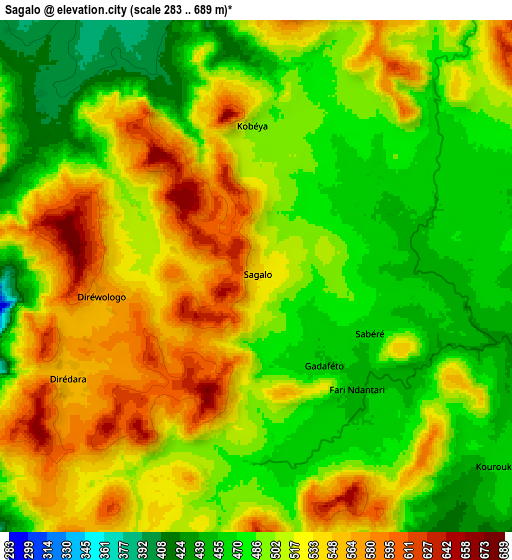
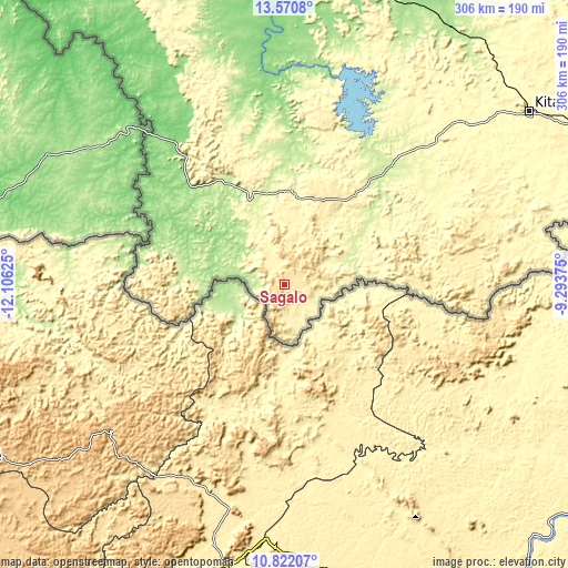
These maps also provides idea of topography and contour of this city, they are displayed at different zoom levels. More info about maps, scale and edge coordinates you can find below images.
| \ | Map #1 | Map #2 | Topo.Map |
| Scale [m] | 440..676 m | 283..689 m | × |
| Scale [ft] | 1444..2218 ft | 928..2260 ft | × |
| Average | 531 m = 1742 ft | 508.1 m = 1667 ft | × |
| Width | 9.55 km = 5.9 mi | 19.1 km = 11.9 mi | 305.6 km = 189.9 mi |
| Height | 9.55 km = 5.9 mi | 19.1 km = 11.9 mi | 305.7 km = 190 mi |
| ↑Max Latitude | 12.242949° | 12.285892° | 13.5708° |
| Latitude at center | 12.2° | 12.2° | 12.2° |
| ↓Min Latitude | 12.157044° | 12.11408° | 10.82207° |
| ← Min Longitude | -10.743945° | -10.787891° | -12.10625° |
| Longitude center | -10.7° | -10.7° | -10.7° |
| →Max Longitude | -10.656055° | -10.612109° | -9.29375° |
Nearby cities:
Cities around Sagalo sort by population:
• Bamako elevation 338 m
297.4 km,  80°
80°
• Kayes 39 m
262.5 km,  342°
342°
• Kati 423 m
291.6 km, 78°
• Bafoulabé 103 m
179.2 km,  355°
355°
• Kangaba 343 m
250 km,  96°
96°
• Kokofata 295 m
111.4 km,  46°
46°
• Diré 208 m
30.4 km,  287°
287°
• Kita 329 m
160.8 km, 54°
• Yélimané 99 m
324.8 km,  2°
2°
• Diéma 255 m
307.1 km,  32°
32°
• Yanfolila 363 m
299.8 km,  112°
112°
• Figuira-Toma 339 m
255.7 km, 97°
Multilingual:
 En español:
Sagalo elevación 540 m.
 En France:
Sagalo élévation 540 m.


Sources and notes:
- [note 1] Map square and city borders are not equal. Map elevation data is calculated only from area inside that square.
- [src 1] Elevation data from geonames database provided with same terms of usage.
- [src 2] The elevation map of Sagalo is generated using elevation data from NASA's 3 arcsec (90m) resolution SRTM data.
- [src 3] Base (background) map © OpenStreetMap contributors tiles are generated by Geofabrik and OpenTopoMap.
Copyright & License:
This Sagalo Elevation Map is licensed under CC BY-SA. You may reuse any part from this page, if you give a proper credit by linking to this URL:
 More info on terms of use page.