Bučin elevation
Bučin (Krushevo), North Macedonia elevation is 604 meters and Bučin elevation in feet is 1982 ft above sea level [src 1]. Bučin is a populated place (feature code) with elevation that is 105 meters (344 ft) bigger than average city elevation in North Macedonia.
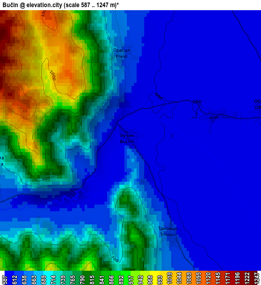
Below is the Elevation map of Bučin, which displays elevation range with different colors. Scale of the first map is from 587 to 1247 m (1926 to 4091 ft) with average elevation of 708.3 meters (=2324 ft) [note 1]
These maps also provides idea of topography and contour of this city, they are displayed at different zoom levels. More info about maps, scale and edge coordinates you can find below images.
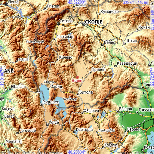
| \ | Map #1 | Topo.Map |
| Scale [m] | 587..1247 m | × |
| Scale [ft] | 1926..4091 ft | × |
| Average | 708.3 m = 2324 ft | × |
| Width | 7.34 km = 4.6 mi | 235 km = 146 mi |
| Height | 7.34 km = 4.6 mi | 235 km = 146 mi |
| ↑Max Latitude | 41.306789° | 42.32209° |
| Latitude at center | 41.27377° | 41.27377° |
| ↓Min Latitude | 41.240734° | 40.20834° |
| ← Min Longitude | 21.272975° | 19.91067° |
| Longitude center | 21.31692° | 21.31692° |
| →Max Longitude | 21.360865° | 22.72317° |
Nearby cities:
Cities around Bučin sort by population:
• Krivogashtani elevation 607 m
7.1 km,  11°
11°
• Krusevo 1207 m
12 km,  331°
331°
• Topolčani 594 m
10.8 km,  118°
118°
• Demir Hisar 644 m
11.2 km,  238°
238°
• Žitoše 640 m
16.4 km,  352°
352°
• Sopotnica 663 m
13.9 km,  280°
280°
• Dobruševo 596 m
18.1 km,  130°
130°
• Dolno Srpci 636 m
11.7 km,  160°
160°
• Beranci 643 m
13.2 km, 164°
• Obršani 597 m
3.8 km,  76°
76°
• Kanatlarci 619 m
17.1 km,  114°
114°
• Slepče 672 m
12.7 km,  249°
249°
Multilingual:
 En español:
Bučin elevación 604 m.
 En France:
Bučin élévation 604 m.


Sources and notes:
- [note 1] Map square and city borders are not equal. Map elevation data is calculated only from area inside that square.
- [src 1] Elevation data from geonames database provided with same terms of usage.
- [src 2] The elevation map of Bučin is generated using elevation data from NASA's 3 arcsec (90m) resolution SRTM data.
- [src 3] Base (background) map © OpenStreetMap contributors tiles are generated by Geofabrik and OpenTopoMap.
Copyright & License:
This Bučin Elevation Map is licensed under CC BY-SA. You may reuse any part from this page, if you give a proper credit by linking to this URL:
 More info on terms of use page.