Čaška elevation
Čaška (Chashka), North Macedonia elevation is 344 meters and Čaška elevation in feet is 1129 ft above sea level [src 1]. Čaška is a seat of a first-order administrative division (feature code) with elevation that is 155 meters (509 ft) smaller than average city elevation in North Macedonia.
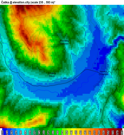
Below is the Elevation map of Čaška, which displays elevation range with different colors. Scale of the first map is from 235 to 593 m (771 to 1946 ft) with average elevation of 342.2 meters (=1123 ft) [note 1]
These maps also provides idea of topography and contour of this city, they are displayed at different zoom levels. More info about maps, scale and edge coordinates you can find below images.
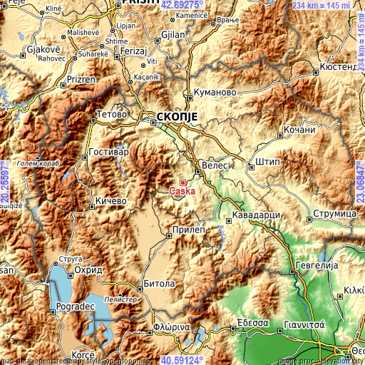
| \ | Map #1 | Topo.Map |
| Scale [m] | 235..593 m | × |
| Scale [ft] | 771..1946 ft | × |
| Average | 342.2 m = 1123 ft | × |
| Width | 7.3 km = 4.5 mi | 233.7 km = 145.2 mi |
| Height | 7.3 km = 4.5 mi | 233.7 km = 145.2 mi |
| ↑Max Latitude | 41.683388° | 42.69275° |
| Latitude at center | 41.65056° | 41.65056° |
| ↓Min Latitude | 41.617715° | 40.59124° |
| ← Min Longitude | 21.618275° | 20.25597° |
| Longitude center | 21.66222° | 21.66222° |
| →Max Longitude | 21.706165° | 23.06847° |
Nearby cities:
Cities around Čaška sort by population:
• Veles elevation 210 m
11.9 km,  52°
52°
• Rosoman 143 m
27.9 km,  122°
122°
• Zelenikovo 223 m
26.7 km,  346°
346°
• Gradsko 159 m
24.7 km,  109°
109°
• Lozovo 287 m
25.1 km, 53°
• Gorno Orizari 306 m
7.2 km,  56°
56°
• Desovo 665 m
25.3 km,  214°
214°
• Crnilište 648 m
24.6 km,  237°
237°
• Dolno Količani 545 m
30 km,  330°
330°
• Bogomila 511 m
17.1 km,  248°
248°
• Ivankovci 486 m
25.7 km,  30°
30°
• Zelenikovo 223 m
25.3 km, 348°
Multilingual:
 En español:
Čaška elevación 344 m.
 En France:
Čaška élévation 344 m.


Sources and notes:
- [note 1] Map square and city borders are not equal. Map elevation data is calculated only from area inside that square.
- [src 1] Elevation data from geonames database provided with same terms of usage.
- [src 2] The elevation map of Čaška is generated using elevation data from NASA's 3 arcsec (90m) resolution SRTM data.
- [src 3] Base (background) map © OpenStreetMap contributors tiles are generated by Geofabrik and OpenTopoMap.
Copyright & License:
This Čaška Elevation Map is licensed under CC BY-SA. You may reuse any part from this page, if you give a proper credit by linking to this URL:
 More info on terms of use page.