Rosoman elevation
Rosoman, North Macedonia elevation is 143 meters and Rosoman elevation in feet is 469 ft above sea level [src 1]. Rosoman is a seat of a first-order administrative division (feature code) with elevation that is 356 meters (1168 ft) smaller than average city elevation in North Macedonia.
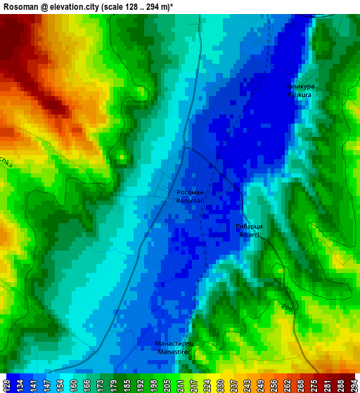
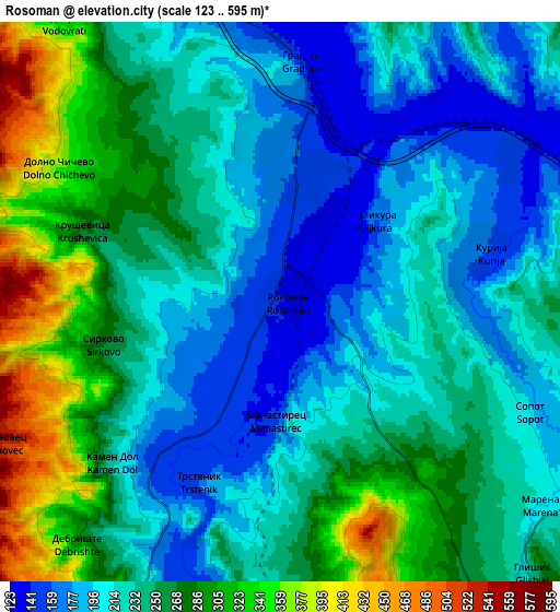
Below is the Elevation map of Rosoman, which displays elevation range with different colors. Scale of the first map is from 128 to 294 m (420 to 965 ft) with average elevation of 181.3 meters (=595 ft) [note 1]
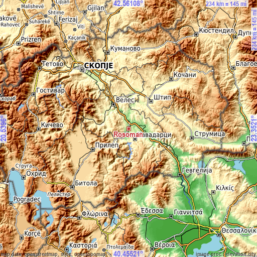
These maps also provides idea of topography and contour of this city, they are displayed at different zoom levels. More info about maps, scale and edge coordinates you can find below images.
| \ | Map #1 | Map #2 | Topo.Map |
| Scale [m] | 128..294 m | 123..595 m | × |
| Scale [ft] | 420..965 ft | 404..1952 ft | × |
| Average | 181.3 m = 595 ft | 241.5 m = 792 ft | × |
| Width | 7.32 km = 4.5 mi | 14.63 km = 9.1 mi | 234.2 km = 145.5 mi |
| Height | 7.32 km = 4.5 mi | 14.63 km = 9.1 mi | 234.1 km = 145.5 mi |
| ↑Max Latitude | 41.549606° | 41.582486° | 42.56108° |
| Latitude at center | 41.51671° | 41.51671° | 41.51671° |
| ↓Min Latitude | 41.483797° | 41.450867° | 40.45521° |
| ← Min Longitude | 21.901905° | 21.857959° | 20.5396° |
| Longitude center | 21.94585° | 21.94585° | 21.94585° |
| →Max Longitude | 21.989795° | 22.033741° | 23.3521° |
Nearby cities:
Cities around Rosoman sort by population:
• Prilep elevation 652 m
37.8 km,  239°
239°
• Veles 210 m
26.3 km,  327°
327°
• Shtip 294 m
32.9 km,  39°
39°
• Kavadarci 276 m
10.8 km,  149°
149°
• Negotino 144 m
12.6 km,  106°
106°
• Demir Kapija 105 m
27.9 km,  116°
116°
• Gradsko 159 m
6.8 km,  357°
357°
• Konče 580 m
36.5 km,  93°
93°
• Čaška 344 m
27.9 km,  302°
302°
• Lozovo 287 m
29.9 km,  353°
353°
• Vataša 294 m
12.7 km, 151°
• Gorno Orizari 306 m
25.7 km,  316°
316°
Multilingual:
 En español:
Rosoman elevación 143 m.
 En France:
Rosoman élévation 143 m.


Sources and notes:
- [note 1] Map square and city borders are not equal. Map elevation data is calculated only from area inside that square.
- [src 1] Elevation data from geonames database provided with same terms of usage.
- [src 2] The elevation map of Rosoman is generated using elevation data from NASA's 3 arcsec (90m) resolution SRTM data.
- [src 3] Base (background) map © OpenStreetMap contributors tiles are generated by Geofabrik and OpenTopoMap.
Copyright & License:
This Rosoman Elevation Map is licensed under CC BY-SA. You may reuse any part from this page, if you give a proper credit by linking to this URL:
 More info on terms of use page.