Kratovo elevation
Kratovo, North Macedonia elevation is 615 meters and Kratovo elevation in feet is 2018 ft above sea level [src 1]. Kratovo is a seat of a first-order administrative division (feature code) with elevation that is 116 meters (381 ft) bigger than average city elevation in North Macedonia.
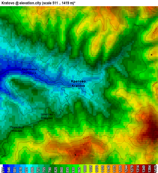
Below is the Elevation map of Kratovo, which displays elevation range with different colors. Scale of the first map is from 511 to 1419 m (1677 to 4656 ft) with average elevation of 896.2 meters (=2940 ft) [note 1]
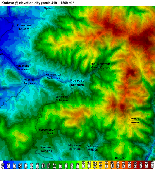
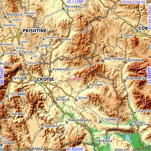
These maps also provides idea of topography and contour of this city, they are displayed at different zoom levels. More info about maps, scale and edge coordinates you can find below images.
| \ | Map #1 | Map #2 | Topo.Map |
| Scale [m] | 511..1419 m | 419..1569 m | × |
| Scale [ft] | 1677..4656 ft | 1375..5148 ft | × |
| Average | 896.2 m = 2940 ft | 898.5 m = 2948 ft | × |
| Width | 7.25 km = 4.5 mi | 14.51 km = 9 mi | 232.1 km = 144.2 mi |
| Height | 7.25 km = 4.5 mi | 14.51 km = 9 mi | 232.1 km = 144.2 mi |
| ↑Max Latitude | 42.110989° | 42.143581° | 43.11355° |
| Latitude at center | 42.07838° | 42.07838° | 42.07838° |
| ↓Min Latitude | 42.045754° | 42.013112° | 41.02605° |
| ← Min Longitude | 22.136755° | 22.092809° | 20.77445° |
| Longitude center | 22.1807° | 22.1807° | 22.1807° |
| →Max Longitude | 22.224645° | 22.268591° | 23.58695° |
Nearby cities:
Cities around Kratovo sort by population:
• Kochani elevation 354 m
26.3 km,  133°
133°
• Kriva Palanka 635 m
18.5 km,  42°
42°
• Sveti Nikole 297 m
29.9 km,  219°
219°
• Probishtip 589 m
8.4 km,  181°
181°
• Oblesevo 305 m
25.1 km,  149°
149°
• Orizari 366 m
28 km, 128°
• Ранковце 472 m
11.5 km,  332°
332°
• Karbinci 288 m
29.3 km,  171°
171°
• Zletovo 477 m
11 km,  155°
155°
• Češinovo 296 m
24.7 km, 158°
• Клечовце 309 m
27 km,  278°
278°
• Orashac 389 m
31.5 km,  266°
266°
Multilingual:
 En español:
Kratovo elevación 615 m.
 En France:
Kratovo élévation 615 m.


Sources and notes:
- [note 1] Map square and city borders are not equal. Map elevation data is calculated only from area inside that square.
- [src 1] Elevation data from geonames database provided with same terms of usage.
- [src 2] The elevation map of Kratovo is generated using elevation data from NASA's 3 arcsec (90m) resolution SRTM data.
- [src 3] Base (background) map © OpenStreetMap contributors tiles are generated by Geofabrik and OpenTopoMap.
Copyright & License:
This Kratovo Elevation Map is licensed under CC BY-SA. You may reuse any part from this page, if you give a proper credit by linking to this URL:
 More info on terms of use page.