Oblesevo elevation
Oblesevo (Češinovo-Obleševo), North Macedonia elevation is 305 meters and Oblesevo elevation in feet is 1001 ft above sea level [src 1]. Oblesevo is a populated place (feature code) with elevation that is 194 meters (636 ft) smaller than average city elevation in North Macedonia.
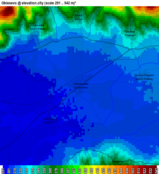
Below is the Elevation map of Oblesevo, which displays elevation range with different colors. Scale of the first map is from 291 to 542 m (955 to 1778 ft) with average elevation of 320.7 meters (=1052 ft) [note 1]
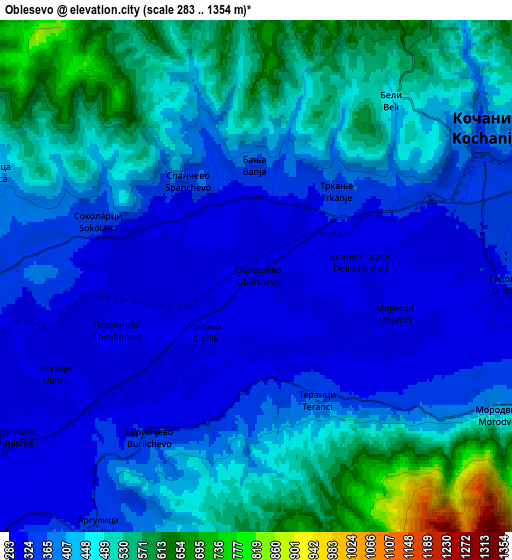
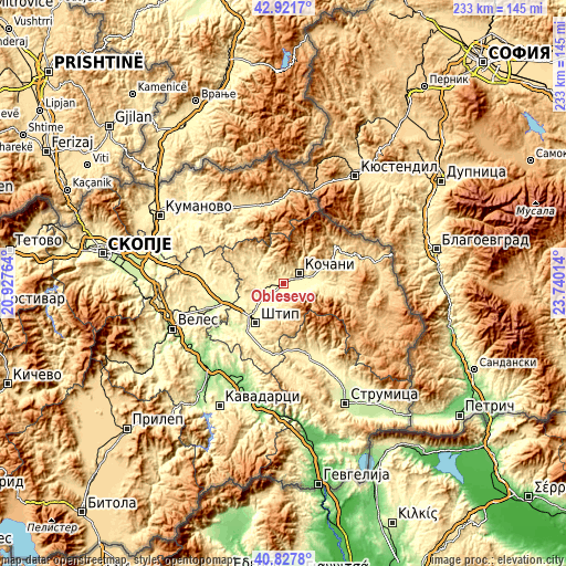
These maps also provides idea of topography and contour of this city, they are displayed at different zoom levels. More info about maps, scale and edge coordinates you can find below images.
| \ | Map #1 | Map #2 | Topo.Map |
| Scale [m] | 291..542 m | 283..1354 m | × |
| Scale [ft] | 955..1778 ft | 928..4442 ft | × |
| Average | 320.7 m = 1052 ft | 428.9 m = 1407 ft | × |
| Width | 7.28 km = 4.5 mi | 14.55 km = 9 mi | 232.8 km = 144.7 mi |
| Height | 7.28 km = 4.5 mi | 14.55 km = 9 mi | 232.8 km = 144.7 mi |
| ↑Max Latitude | 41.916039° | 41.948732° | 42.9217° |
| Latitude at center | 41.88333° | 41.88333° | 41.88333° |
| ↓Min Latitude | 41.850604° | 41.817861° | 40.8278° |
| ← Min Longitude | 22.289945° | 22.245999° | 20.92764° |
| Longitude center | 22.33389° | 22.33389° | 22.33389° |
| →Max Longitude | 22.377835° | 22.421781° | 23.74014° |
Nearby cities:
Cities around Oblesevo sort by population:
• Shtip elevation 294 m
19.1 km,  216°
216°
• Kochani 354 m
7.5 km,  60°
60°
• Vinica 407 m
14.5 km,  90°
90°
• Probishtip 589 m
18.5 km,  316°
316°
• Kratovo 615 m
25.1 km,  329°
329°
• Orizari 366 m
10.3 km, 64°
• Karbinci 288 m
11 km,  228°
228°
• Zletovo 477 m
14.2 km, 325°
• Zrnovci 361 m
9.7 km,  109°
109°
• Češinovo 296 m
3.9 km,  250°
250°
• Blatec 702 m
21 km,  104°
104°
• Gradec 515 m
15.1 km, 103°
Multilingual:
 En español:
Oblesevo elevación 305 m.
 En France:
Oblesevo élévation 305 m.
 Auf Deutsch:
Oblesevo höhe über dem Meeresspiegel ist 305 m.

Sources and notes:
- [note 1] Map square and city borders are not equal. Map elevation data is calculated only from area inside that square.
- [src 1] Elevation data from geonames database provided with same terms of usage.
- [src 2] The elevation map of Oblesevo is generated using elevation data from NASA's 3 arcsec (90m) resolution SRTM data.
- [src 3] Base (background) map © OpenStreetMap contributors tiles are generated by Geofabrik and OpenTopoMap.
Copyright & License:
This Oblesevo Elevation Map is licensed under CC BY-SA. You may reuse any part from this page, if you give a proper credit by linking to this URL:
 More info on terms of use page.