Struga elevation
Struga, North Macedonia elevation is 696 meters and Struga elevation in feet is 2283 ft above sea level [src 1]. Struga is a seat of a first-order administrative division (feature code) with elevation that is 197 meters (646 ft) bigger than average city elevation in North Macedonia.
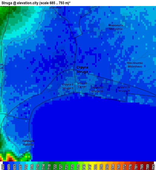
Below is the Elevation map of Struga, which displays elevation range with different colors. Scale of the first map is from 685 to 793 m (2247 to 2602 ft) with average elevation of 693.5 meters (=2275 ft) [note 1]
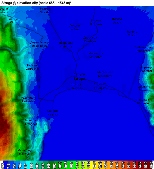
These maps also provides idea of topography and contour of this city, they are displayed at different zoom levels. More info about maps, scale and edge coordinates you can find below images.
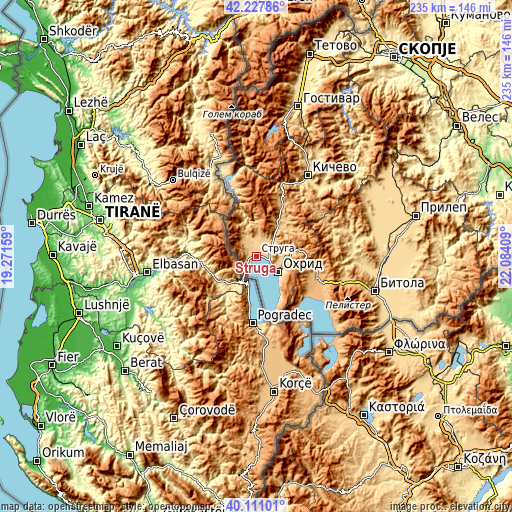
| \ | Map #1 | Map #2 | Topo.Map |
| Scale [m] | 685..793 m | 685..1543 m | × |
| Scale [ft] | 2247..2602 ft | 2247..5062 ft | × |
| Average | 693.5 m = 2275 ft | 770 m = 2526 ft | × |
| Width | 7.36 km = 4.6 mi | 14.71 km = 9.1 mi | 235.4 km = 146.3 mi |
| Height | 7.36 km = 4.6 mi | 14.71 km = 9.1 mi | 235.4 km = 146.3 mi |
| ↑Max Latitude | 41.211058° | 41.244109° | 42.22786° |
| Latitude at center | 41.17799° | 41.17799° | 41.17799° |
| ↓Min Latitude | 41.144905° | 41.111804° | 40.11101° |
| ← Min Longitude | 20.633895° | 20.589949° | 19.27159° |
| Longitude center | 20.67784° | 20.67784° | 20.67784° |
| →Max Longitude | 20.721785° | 20.765731° | 22.08409° |
Nearby cities:
Cities around Struga sort by population:
• Ohrid elevation 701 m
12.4 km,  123°
123°
• Labunista 865 m
12.2 km,  325°
325°
• Velesta 716 m
7.5 km,  337°
337°
• Delogožda 773 m
9.6 km,  22°
22°
• Radolista 741 m
4.8 km,  251°
251°
• Belčišta 770 m
18.8 km,  42°
42°
• Oktisi 796 m
8.5 km,  315°
315°
• Mešeišta 757 m
10.5 km,  50°
50°
• Vevčani 867 m
9.9 km,  314°
314°
• Mislesevo 695 m
2.7 km,  73°
73°
• Lukovo 681 m
20.4 km, 342°
• Kosel 747 m
13.2 km,  91°
91°
Multilingual:
 En español:
Struga elevación 696 m.
 En France:
Struga élévation 696 m.


Sources and notes:
- [note 1] Map square and city borders are not equal. Map elevation data is calculated only from area inside that square.
- [src 1] Elevation data from geonames database provided with same terms of usage.
- [src 2] The elevation map of Struga is generated using elevation data from NASA's 3 arcsec (90m) resolution SRTM data.
- [src 3] Base (background) map © OpenStreetMap contributors tiles are generated by Geofabrik and OpenTopoMap.
Copyright & License:
This Struga Elevation Map is licensed under CC BY-SA. You may reuse any part from this page, if you give a proper credit by linking to this URL:
 More info on terms of use page.