Bemaitso elevation
Bemaitso (Alaotra Mangoro, Andilamena District), Madagascar elevation is 937 meters and Bemaitso elevation in feet is 3074 ft above sea level [src 1]. Bemaitso is a populated place (feature code) with elevation that is 380 meters (1247 ft) bigger than average city elevation in Madagascar.
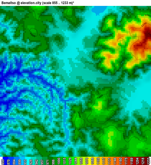
Below is the Elevation map of Bemaitso, which displays elevation range with different colors. Scale of the first map is from 855 to 1233 m (2805 to 4045 ft) with average elevation of 963.6 meters (=3161 ft) [note 1]
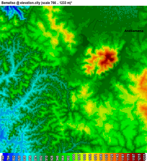
These maps also provides idea of topography and contour of this city, they are displayed at different zoom levels. More info about maps, scale and edge coordinates you can find below images.
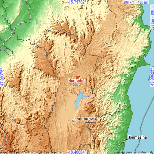
| \ | Map #1 | Map #2 | Topo.Map |
| Scale [m] | 855..1233 m | 766..1233 m | × |
| Scale [ft] | 2805..4045 ft | 2513..4045 ft | × |
| Average | 963.6 m = 3161 ft | 947.4 m = 3108 ft | × |
| Width | 9.34 km = 5.8 mi | 18.68 km = 11.6 mi | 298.9 km = 185.7 mi |
| Height | 9.34 km = 5.8 mi | 18.68 km = 11.6 mi | 298.9 km = 185.7 mi |
| ↑Max Latitude | -17.024655° | -16.982631° | -15.71762° |
| Latitude at center | -17.06667° | -17.06667° | -17.06667° |
| ↓Min Latitude | -17.108675° | -17.150671° | -18.40604° |
| ← Min Longitude | 48.456055° | 48.412109° | 47.09375° |
| Longitude center | 48.5° | 48.5° | 48.5° |
| →Max Longitude | 48.543945° | 48.587891° | 49.90625° |
Nearby cities:
Cities around Bemaitso sort by population:
• Amparafaravola elevation 777 m
64.9 km,  206°
206°
• Ambatondrazaka 768 m
85.7 km,  185°
185°
• Soanierana Ivongo 117 m
116.4 km,  81°
81°
• Vavatenina 117 m
86.6 km,  120°
120°
• Vohibinany 171 m
64.8 km, 119°
• Fenoarivo Atsinanana 14 m
102.6 km,  109°
109°
• Andilamena 933 m
10 km,  51°
51°
• Tsaratanana 349 m
95.1 km,  288°
288°
• Antsirabe Afovoany 359 m
133.8 km,  21°
21°
• Sahatavy 187 m
68.1 km,  128°
128°
• Mahavelona 11 m
127.2 km, 122°
• Mandritsara 513 m
138.9 km,  14°
14°
Multilingual:
 En español:
Bemaitso elevación 937 m.
 En France:
Bemaitso élévation 937 m.
 Auf Deutsch:
Bemaitso höhe über dem Meeresspiegel ist 937 m.

Sources and notes:
- [note 1] Map square and city borders are not equal. Map elevation data is calculated only from area inside that square.
- [src 1] Elevation data from geonames database provided with same terms of usage.
- [src 2] The elevation map of Bemaitso is generated using elevation data from NASA's 3 arcsec (90m) resolution SRTM data.
- [src 3] Base (background) map © OpenStreetMap contributors tiles are generated by Geofabrik and OpenTopoMap.
Copyright & License:
This Bemaitso Elevation Map is licensed under CC BY-SA. You may reuse any part from this page, if you give a proper credit by linking to this URL:
 More info on terms of use page.