Fenoarivo Atsinanana elevation
Fenoarivo Atsinanana (Analanjirofo), Madagascar elevation is 14 meters and Fenoarivo Atsinanana elevation in feet is 46 ft above sea level [src 1]. Fenoarivo Atsinanana is a seat of a first-order administrative division (feature code) with elevation that is 543 meters (1781 ft) smaller than average city elevation in Madagascar.
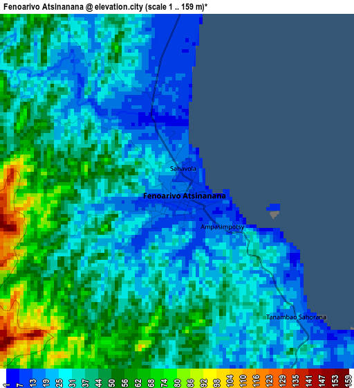
Below is the Elevation map of Fenoarivo Atsinanana, which displays elevation range with different colors. Scale of the first map is from 1 to 159 m (3 to 522 ft) with average elevation of 38.7 meters (=127 ft) [note 1]
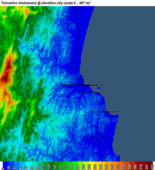
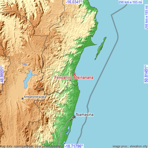
These maps also provides idea of topography and contour of this city, they are displayed at different zoom levels. More info about maps, scale and edge coordinates you can find below images.
| \ | Map #1 | Map #2 | Topo.Map |
| Scale [m] | 1..159 m | 0..407 m | × |
| Scale [ft] | 3..522 ft | 0..1335 ft | × |
| Average | 38.7 m = 127 ft | 80.6 m = 264 ft | × |
| Width | 9.33 km = 5.8 mi | 18.65 km = 11.6 mi | 298.4 km = 185.4 mi |
| Height | 9.33 km = 5.8 mi | 18.65 km = 11.6 mi | 298.4 km = 185.4 mi |
| ↑Max Latitude | -17.339006° | -17.297053° | -16.0341° |
| Latitude at center | -17.38095° | -17.38095° | -17.38095° |
| ↓Min Latitude | -17.422884° | -17.464808° | -18.71796° |
| ← Min Longitude | 49.364315° | 49.320369° | 48.00201° |
| Longitude center | 49.40826° | 49.40826° | 49.40826° |
| →Max Longitude | 49.452205° | 49.496151° | 50.81451° |
Nearby cities:
Cities around Fenoarivo Atsinanana sort by population:
• Toamasina elevation 12 m
85.4 km,  180°
180°
• Amparafaravola 777 m
127.7 km,  259°
259°
• Ambatondrazaka 768 m
116.5 km,  244°
244°
• Mananara 15 m
140.1 km,  15°
15°
• Soanierana Ivongo 117 m
54.9 km, 19°
• Vavatenina 117 m
24.1 km,  246°
246°
• Vohibinany 171 m
39.9 km,  274°
274°
• Andilamena 933 m
97.8 km,  294°
294°
• Ambodifotatra 5 m
64.5 km,  46°
46°
• Sahatavy 187 m
44 km, 259°
• Bemaitso 937 m
102.6 km, 289°
• Mahavelona 11 m
35.4 km,  162°
162°
Multilingual:
 En español:
Fenoarivo Atsinanana elevación 14 m.
 En France:
Fenoarivo Atsinanana élévation 14 m.
 Auf Deutsch:
Fenoarivo Atsinanana höhe über dem Meeresspiegel ist 14 m.
 На русском:
Fenoarivo Atsinanana высота над уровнем моря 14 м
Sources and notes:
- [note 1] Map square and city borders are not equal. Map elevation data is calculated only from area inside that square.
- [src 1] Elevation data from geonames database provided with same terms of usage.
- [src 2] The elevation map of Fenoarivo Atsinanana is generated using elevation data from NASA's 3 arcsec (90m) resolution SRTM data.
- [src 3] Base (background) map © OpenStreetMap contributors tiles are generated by Geofabrik and OpenTopoMap.
Copyright & License:
This Fenoarivo Atsinanana Elevation Map is licensed under CC BY-SA. You may reuse any part from this page, if you give a proper credit by linking to this URL:
 More info on terms of use page.