Budva elevation
Budva, Montenegro elevation is 7 meters and Budva elevation in feet is 23 ft above sea level [src 1]. Budva is a seat of a first-order administrative division (feature code) with elevation that is 336 meters (1102 ft) smaller than average city elevation in Montenegro.
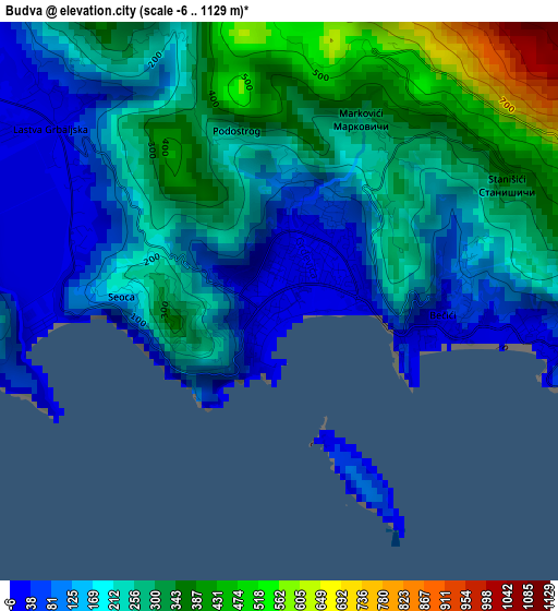
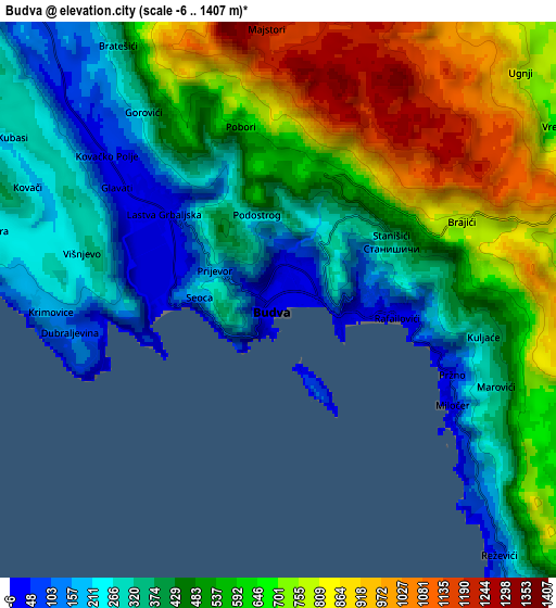
Below is the Elevation map of Budva, which displays elevation range with different colors. Scale of the first map is from -6 to 1129 m (-20 to 3704 ft) with average elevation of 224.2 meters (=736 ft) [note 1]
These maps also provides idea of topography and contour of this city, they are displayed at different zoom levels. More info about maps, scale and edge coordinates you can find below images.
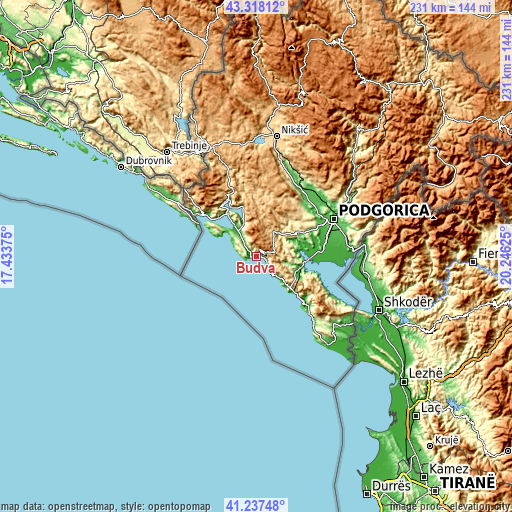
| \ | Map #1 | Map #2 | Topo.Map |
| Scale [m] | -6..1129 m | -6..1407 m | × |
| Scale [ft] | -20..3704 ft | -20..4616 ft | × |
| Average | 224.2 m = 736 ft | 515.7 m = 1692 ft | × |
| Width | 7.23 km = 4.5 mi | 14.46 km = 9 mi | 231.3 km = 143.7 mi |
| Height | 7.23 km = 4.5 mi | 14.46 km = 9 mi | 231.3 km = 143.7 mi |
| ↑Max Latitude | 42.318892° | 42.351377° | 43.31812° |
| Latitude at center | 42.28639° | 42.28639° | 42.28639° |
| ↓Min Latitude | 42.253871° | 42.221336° | 41.23748° |
| ← Min Longitude | 18.796055° | 18.752109° | 17.43375° |
| Longitude center | 18.84° | 18.84° | 18.84° |
| →Max Longitude | 18.883945° | 18.927891° | 20.24625° |
Nearby cities:
Cities around Budva sort by population:
• Bar elevation 4 m
30.4 km,  135°
135°
• Cetinje 686 m
13.1 km,  27°
27°
• Tivat 6 m
20.4 km,  324°
324°
• Dobrota 69 m
19.6 km,  342°
342°
• Kotor 5 m
16.1 km, 338°
• Šušanj 45 m
27.9 km,  132°
132°
• Bijela 6 m
24 km, 320°
• Risan 12 m
28 km,  334°
334°
• Sutomore 30 m
23.3 km, 133°
• Petrovac na Moru 9 m
12.3 km, 136°
• Prčanj 8 m
20.7 km, 337°
• Lipci 5 m
27.8 km, 327°
Multilingual:
 En español:
Budva elevación 7 m.
 En France:
Budva élévation 7 m.


Sources and notes:
- [note 1] Map square and city borders are not equal. Map elevation data is calculated only from area inside that square.
- [src 1] Elevation data from geonames database provided with same terms of usage.
- [src 2] The elevation map of Budva is generated using elevation data from NASA's 3 arcsec (90m) resolution SRTM data.
- [src 3] Base (background) map © OpenStreetMap contributors tiles are generated by Geofabrik and OpenTopoMap.
Copyright & License:
This Budva Elevation Map is licensed under CC BY-SA. You may reuse any part from this page, if you give a proper credit by linking to this URL:
 More info on terms of use page.