Mojkovac elevation
Mojkovac, Montenegro elevation is 826 meters and Mojkovac elevation in feet is 2710 ft above sea level [src 1]. Mojkovac is a seat of a first-order administrative division (feature code) with elevation that is 483 meters (1585 ft) bigger than average city elevation in Montenegro.
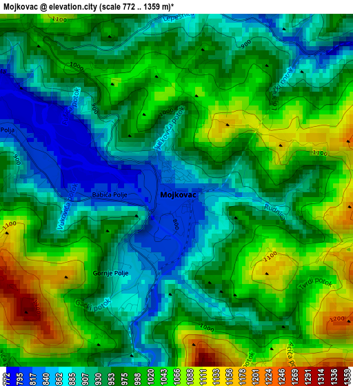
Below is the Elevation map of Mojkovac, which displays elevation range with different colors. Scale of the first map is from 772 to 1359 m (2533 to 4459 ft) with average elevation of 973.3 meters (=3193 ft) [note 1]
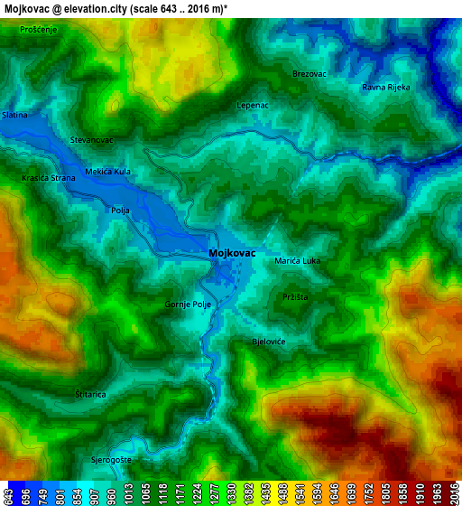
These maps also provides idea of topography and contour of this city, they are displayed at different zoom levels. More info about maps, scale and edge coordinates you can find below images.
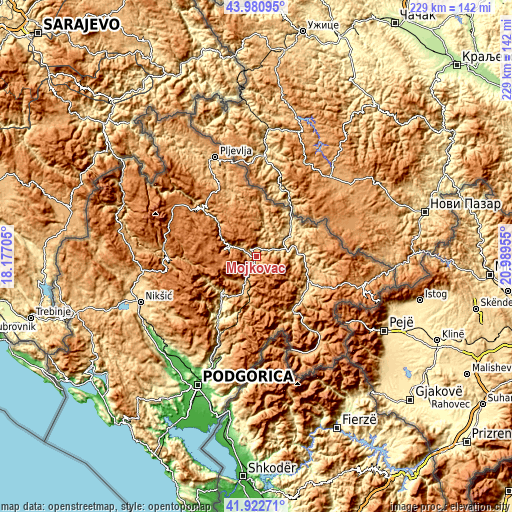
| \ | Map #1 | Map #2 | Topo.Map |
| Scale [m] | 772..1359 m | 643..2016 m | × |
| Scale [ft] | 2533..4459 ft | 2110..6614 ft | × |
| Average | 973.3 m = 3193 ft | 1145.4 m = 3758 ft | × |
| Width | 7.15 km = 4.4 mi | 14.3 km = 8.9 mi | 228.9 km = 142.2 mi |
| Height | 7.15 km = 4.4 mi | 14.3 km = 8.9 mi | 228.8 km = 142.2 mi |
| ↑Max Latitude | 42.992592° | 43.024727° | 43.98095° |
| Latitude at center | 42.96044° | 42.96044° | 42.96044° |
| ↓Min Latitude | 42.928271° | 42.896086° | 41.92271° |
| ← Min Longitude | 19.539355° | 19.495409° | 18.17705° |
| Longitude center | 19.5833° | 19.5833° | 19.5833° |
| →Max Longitude | 19.627245° | 19.671191° | 20.98955° |
Nearby cities:
Cities around Mojkovac sort by population:
• Nikšić elevation 630 m
56.1 km,  248°
248°
• Pljevlja 772 m
47.7 km,  337°
337°
• Bijelo Polje 623 m
15.9 km,  57°
57°
• Berane 676 m
27 km,  119°
119°
• Rožaje 1081 m
49.6 km,  106°
106°
• Plav 948 m
50.1 km,  143°
143°
• Kolašin 936 m
16.3 km,  199°
199°
• Žabljak 1448 m
43.1 km,  299°
299°
• Andrijevica 783 m
30.4 km,  145°
145°
• Šavnik 843 m
39.6 km,  269°
269°
• Gusinje 924 m
48.8 km,  155°
155°
• Petnjica 724 m
31.6 km,  100°
100°
Multilingual:
 En español:
Mojkovac elevación 826 m.
 En France:
Mojkovac élévation 826 m.
 Auf Deutsch:
Mojkovac höhe über dem Meeresspiegel ist 826 m.

Sources and notes:
- [note 1] Map square and city borders are not equal. Map elevation data is calculated only from area inside that square.
- [src 1] Elevation data from geonames database provided with same terms of usage.
- [src 2] The elevation map of Mojkovac is generated using elevation data from NASA's 3 arcsec (90m) resolution SRTM data.
- [src 3] Base (background) map © OpenStreetMap contributors tiles are generated by Geofabrik and OpenTopoMap.
Copyright & License:
This Mojkovac Elevation Map is licensed under CC BY-SA. You may reuse any part from this page, if you give a proper credit by linking to this URL:
 More info on terms of use page.