Nikšić elevation
Nikšić (Opština Nikšić), Montenegro elevation is 630 meters and Nikšić elevation in feet is 2067 ft above sea level [src 1]. Nikšić is a seat of a first-order administrative division (feature code) with elevation that is 287 meters (942 ft) bigger than average city elevation in Montenegro.
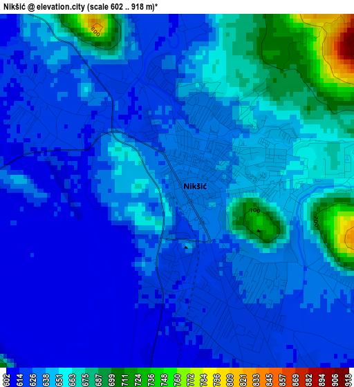
Below is the Elevation map of Nikšić, which displays elevation range with different colors. Scale of the first map is from 602 to 918 m (1975 to 3012 ft) with average elevation of 640 meters (=2100 ft) [note 1]
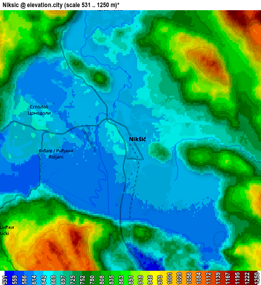
These maps also provides idea of topography and contour of this city, they are displayed at different zoom levels. More info about maps, scale and edge coordinates you can find below images.
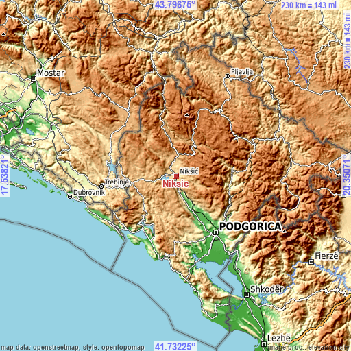
| \ | Map #1 | Map #2 | Topo.Map |
| Scale [m] | 602..918 m | 531..1250 m | × |
| Scale [ft] | 1975..3012 ft | 1742..4101 ft | × |
| Average | 640 m = 2100 ft | 736.8 m = 2417 ft | × |
| Width | 7.17 km = 4.5 mi | 14.35 km = 8.9 mi | 229.6 km = 142.7 mi |
| Height | 7.17 km = 4.5 mi | 14.35 km = 8.9 mi | 229.5 km = 142.6 mi |
| ↑Max Latitude | 42.80535° | 42.837582° | 43.79675° |
| Latitude at center | 42.7731° | 42.7731° | 42.7731° |
| ↓Min Latitude | 42.740834° | 42.70855° | 41.73225° |
| ← Min Longitude | 18.900515° | 18.856569° | 17.53821° |
| Longitude center | 18.94446° | 18.94446° | 18.94446° |
| →Max Longitude | 18.988405° | 19.032351° | 20.35071° |
Nearby cities:
Cities around Nikšić sort by population:
• Cetinje elevation 686 m
42.6 km,  183°
183°
• Tivat 6 m
42.6 km,  208°
208°
• Dobrota 69 m
38.3 km,  202°
202°
• Kotor 5 m
41.8 km, 200°
• Danilovgrad 49 m
29.4 km,  145°
145°
• Bijela 6 m
42.7 km, 213°
• Risan 12 m
35.2 km,  215°
215°
• Plužine 693 m
43.1 km,  348°
348°
• Prčanj 8 m
38.8 km, 205°
• Spuž 61 m
35.3 km,  144°
144°
• Lipci 5 m
38.6 km, 217°
• Šavnik 843 m
23.9 km,  31°
31°
Multilingual:
 En español:
Nikšić elevación 630 m.
 En France:
Nikšić élévation 630 m.


Sources and notes:
- [note 1] Map square and city borders are not equal. Map elevation data is calculated only from area inside that square.
- [src 1] Elevation data from geonames database provided with same terms of usage.
- [src 2] The elevation map of Nikšić is generated using elevation data from NASA's 3 arcsec (90m) resolution SRTM data.
- [src 3] Base (background) map © OpenStreetMap contributors tiles are generated by Geofabrik and OpenTopoMap.
Copyright & License:
This Nikšić Elevation Map is licensed under CC BY-SA. You may reuse any part from this page, if you give a proper credit by linking to this URL:
 More info on terms of use page.