Podgorica elevation
Podgorica, Montenegro elevation is 49 meters and Podgorica elevation in feet is 161 ft above sea level [src 1]. Podgorica is a capital of a political entity (feature code) with elevation that is 294 meters (965 ft) smaller than average city elevation in Montenegro.
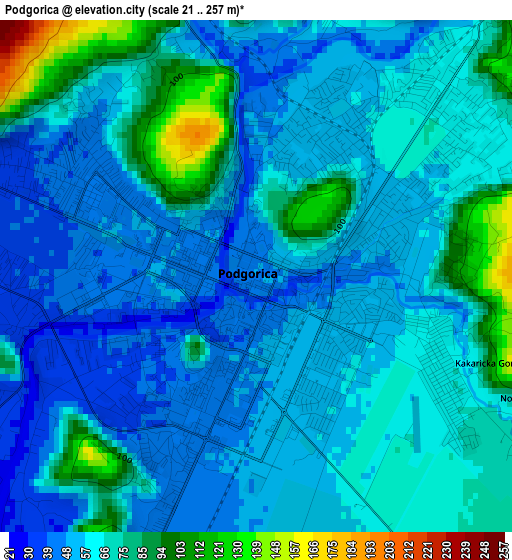
Below is the Elevation map of Podgorica, which displays elevation range with different colors. Scale of the first map is from 21 to 257 m (69 to 843 ft) with average elevation of 63.3 meters (=208 ft) [note 1]
These maps also provides idea of topography and contour of this city, they are displayed at different zoom levels. More info about maps, scale and edge coordinates you can find below images.
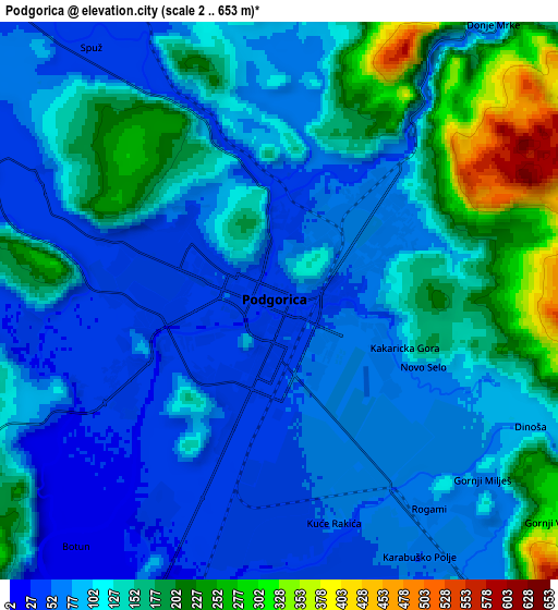
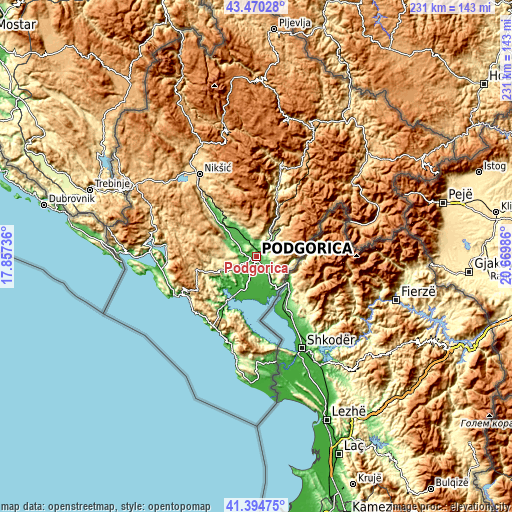
| \ | Map #1 | Map #2 | Topo.Map |
| Scale [m] | 21..257 m | 2..653 m | × |
| Scale [ft] | 69..843 ft | 7..2142 ft | × |
| Average | 63.3 m = 208 ft | 118.5 m = 389 ft | × |
| Width | 7.21 km = 4.5 mi | 14.42 km = 9 mi | 230.8 km = 143.4 mi |
| Height | 7.21 km = 4.5 mi | 14.42 km = 9 mi | 230.8 km = 143.4 mi |
| ↑Max Latitude | 42.473532° | 42.505937° | 43.47028° |
| Latitude at center | 42.44111° | 42.44111° | 42.44111° |
| ↓Min Latitude | 42.408671° | 42.376216° | 41.39475° |
| ← Min Longitude | 19.219665° | 19.175719° | 17.85736° |
| Longitude center | 19.26361° | 19.26361° | 19.26361° |
| →Max Longitude | 19.307555° | 19.351501° | 20.66986° |
Nearby cities:
Cities around Podgorica sort by population:
• Budva elevation 7 m
38.8 km,  243°
243°
• Cetinje 686 m
29.2 km,  258°
258°
• Danilovgrad 49 m
15.8 km,  322°
322°
• Tuzi 48 m
10.1 km,  146°
146°
• Šušanj 45 m
39 km,  201°
201°
• Sutomore 30 m
37.7 km,  208°
208°
• Mojanovići 11 m
11.6 km, 197°
• Petrovac na Moru 9 m
37.2 km,  225°
225°
• Spuž 61 m
10 km,  325°
325°
• Goričani 11 m
12.8 km, 199°
• Mataguži 16 m
13.1 km,  176°
176°
• Golubovci 12 m
12.1 km,  192°
192°
Multilingual:
 En español:
Podgorica elevación 49 m.
 En France:
Podgorica élévation 49 m.
 Auf Deutsch:
Podgorica höhe über dem Meeresspiegel ist 49 m.

Sources and notes:
- [note 1] Map square and city borders are not equal. Map elevation data is calculated only from area inside that square.
- [src 1] Elevation data from geonames database provided with same terms of usage.
- [src 2] The elevation map of Podgorica is generated using elevation data from NASA's 3 arcsec (90m) resolution SRTM data.
- [src 3] Base (background) map © OpenStreetMap contributors tiles are generated by Geofabrik and OpenTopoMap.
Copyright & License:
This Podgorica Elevation Map is licensed under CC BY-SA. You may reuse any part from this page, if you give a proper credit by linking to this URL:
 More info on terms of use page.