Iargara elevation
Iargara (Cantemir), Moldova elevation is 125 meters and Iargara elevation in feet is 410 ft above sea level [src 1]. Iargara is a populated place (feature code) with elevation that is 32 meters (105 ft) bigger than average city elevation in Moldova.
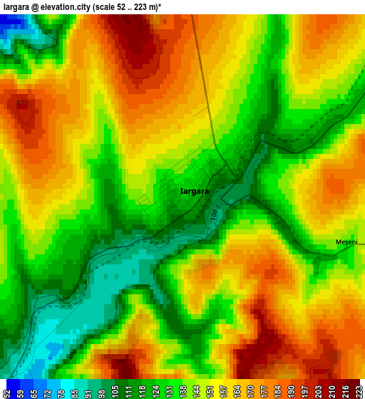
Below is the Elevation map of Iargara, which displays elevation range with different colors. Scale of the first map is from 52 to 223 m (171 to 732 ft) with average elevation of 146.9 meters (=482 ft) [note 1]
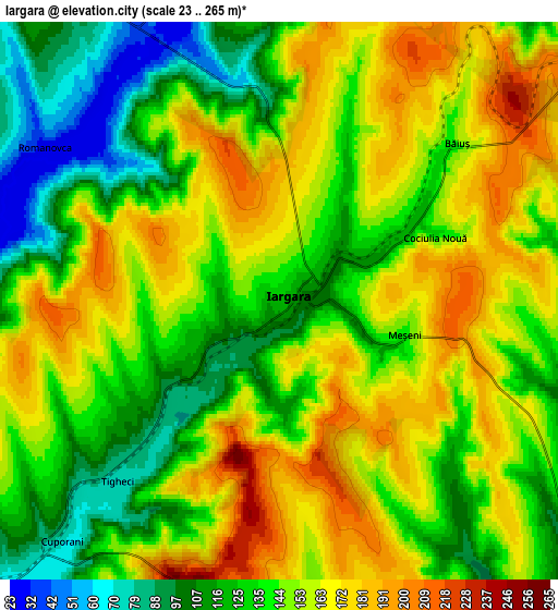
These maps also provides idea of topography and contour of this city, they are displayed at different zoom levels. More info about maps, scale and edge coordinates you can find below images.
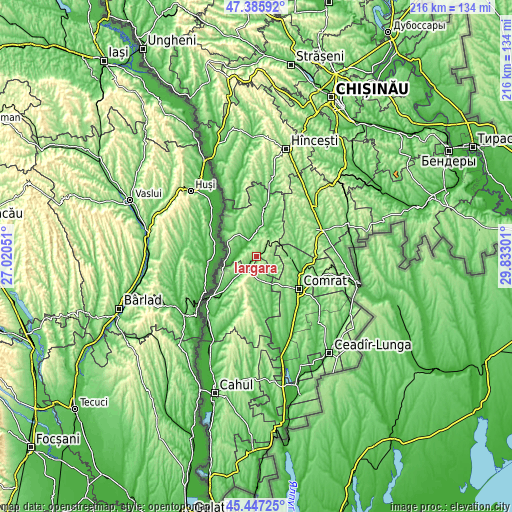
| \ | Map #1 | Map #2 | Topo.Map |
| Scale [m] | 52..223 m | 23..265 m | × |
| Scale [ft] | 171..732 ft | 75..869 ft | × |
| Average | 146.9 m = 482 ft | 145.7 m = 478 ft | × |
| Width | 6.74 km = 4.2 mi | 13.47 km = 8.4 mi | 215.6 km = 134 mi |
| Height | 6.74 km = 4.2 mi | 13.47 km = 8.4 mi | 215.5 km = 133.9 mi |
| ↑Max Latitude | 46.455483° | 46.485749° | 47.38592° |
| Latitude at center | 46.4252° | 46.4252° | 46.4252° |
| ↓Min Latitude | 46.3949° | 46.364583° | 45.44725° |
| ← Min Longitude | 28.382815° | 28.338869° | 27.02051° |
| Longitude center | 28.42676° | 28.42676° | 28.42676° |
| →Max Longitude | 28.470705° | 28.514651° | 29.83301° |
Nearby cities:
Cities around Iargara sort by population:
• Cahul elevation 50 m
60.5 km,  196°
196°
• Comrat 62 m
22.8 km,  129°
129°
• Ceadîr-Lunga 45 m
51 km,  142°
142°
• Hînceşti 127 m
46.8 km,  15°
15°
• Leova 37 m
14.7 km,  295°
295°
• Cimişlia 115 m
28.2 km,  66°
66°
• Basarabeasca 60 m
42.5 km,  104°
104°
• Dancu 24 m
40.6 km,  335°
335°
• Tvardița 104 m
51.6 km, 126°
• Cantemir 56 m
23.8 km,  226°
226°
• Bugeac 93 m
19.3 km,  110°
110°
• Vişniovca 116 m
10.4 km,  171°
171°
Multilingual:
 En español:
Iargara elevación 125 m.
 En France:
Iargara élévation 125 m.


Sources and notes:
- [note 1] Map square and city borders are not equal. Map elevation data is calculated only from area inside that square.
- [src 1] Elevation data from geonames database provided with same terms of usage.
- [src 2] The elevation map of Iargara is generated using elevation data from NASA's 3 arcsec (90m) resolution SRTM data.
- [src 3] Base (background) map © OpenStreetMap contributors tiles are generated by Geofabrik and OpenTopoMap.
Copyright & License:
This Iargara Elevation Map is licensed under CC BY-SA. You may reuse any part from this page, if you give a proper credit by linking to this URL:
 More info on terms of use page.