Hînceşti elevation
Hînceşti, Moldova elevation is 127 meters and Hînceşti elevation in feet is 417 ft above sea level [src 1]. Hînceşti is a seat of a first-order administrative division (feature code) with elevation that is 34 meters (112 ft) bigger than average city elevation in Moldova.
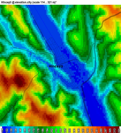
Below is the Elevation map of Hînceşti, which displays elevation range with different colors. Scale of the first map is from 114 to 321 m (374 to 1053 ft) with average elevation of 185.7 meters (=609 ft) [note 1]
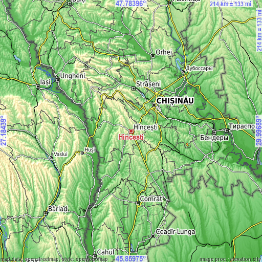
These maps also provides idea of topography and contour of this city, they are displayed at different zoom levels. More info about maps, scale and edge coordinates you can find below images.
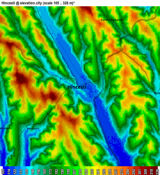
| \ | Map #1 | Map #2 | Topo.Map |
| Scale [m] | 114..321 m | 105..326 m | × |
| Scale [ft] | 374..1053 ft | 344..1070 ft | × |
| Average | 185.7 m = 609 ft | 197.1 m = 647 ft | × |
| Width | 6.69 km = 4.2 mi | 13.37 km = 8.3 mi | 214 km = 133 mi |
| Height | 6.69 km = 4.2 mi | 13.37 km = 8.3 mi | 213.9 km = 132.9 mi |
| ↑Max Latitude | 46.860527° | 46.890568° | 47.78396° |
| Latitude at center | 46.83047° | 46.83047° | 46.83047° |
| ↓Min Latitude | 46.800396° | 46.770305° | 45.85975° |
| ← Min Longitude | 28.546695° | 28.502749° | 27.18439° |
| Longitude center | 28.59064° | 28.59064° | 28.59064° |
| →Max Longitude | 28.634585° | 28.678531° | 29.99689° |
Nearby cities:
Cities around Hînceşti sort by population:
• Chisinau elevation 55 m
28.1 km,  46°
46°
• Strășeni 107 m
34.7 km,  2°
2°
• Ialoveni 97 m
19.2 km, 49°
• Cimişlia 115 m
36.3 km,  158°
158°
• Nisporeni 120 m
42.3 km,  311°
311°
• Dancu 24 m
30.3 km,  254°
254°
• Cricova 134 m
39.9 km,  30°
30°
• Sîngera 50 m
30.1 km,  71°
71°
• Ciorescu 105 m
40.3 km, 34°
• Stăuceni 188 m
36.3 km,  35°
35°
• Vatra 67 m
29.3 km,  22°
22°
• Bucovăţ 115 m
41.3 km,  345°
345°
Multilingual:
 En español:
Hînceşti elevación 127 m.
 En France:
Hînceşti élévation 127 m.
 Auf Deutsch:
Hînceşti höhe über dem Meeresspiegel ist 127 m.

Sources and notes:
- [note 1] Map square and city borders are not equal. Map elevation data is calculated only from area inside that square.
- [src 1] Elevation data from geonames database provided with same terms of usage.
- [src 2] The elevation map of Hînceşti is generated using elevation data from NASA's 3 arcsec (90m) resolution SRTM data.
- [src 3] Base (background) map © OpenStreetMap contributors tiles are generated by Geofabrik and OpenTopoMap.
Copyright & License:
This Hînceşti Elevation Map is licensed under CC BY-SA. You may reuse any part from this page, if you give a proper credit by linking to this URL:
 More info on terms of use page.