Cap Negro II elevation
Cap Negro II (Tanger-Tetouan-Al Hoceima), Morocco elevation is 7 meters and Cap Negro II elevation in feet is 23 ft above sea level [src 1]. Cap Negro II is a populated place (feature code) with elevation that is 609 meters (1998 ft) smaller than average city elevation in Morocco.
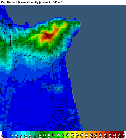
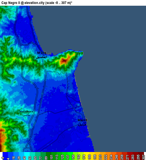
Below is the Elevation map of Cap Negro II, which displays elevation range with different colors. Scale of the first map is from -5 to 306 m (-16 to 1004 ft) with average elevation of 32.6 meters (=107 ft) [note 1]
These maps also provides idea of topography and contour of this city, they are displayed at different zoom levels. More info about maps, scale and edge coordinates you can find below images.
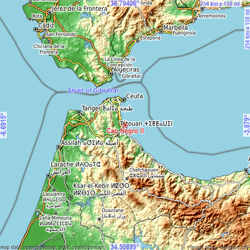
| \ | Map #1 | Map #2 | Topo.Map |
| Scale [m] | -5..306 m | -8..307 m | × |
| Scale [ft] | -16..1004 ft | -26..1007 ft | × |
| Average | 32.6 m = 107 ft | 37.7 m = 124 ft | × |
| Width | 7.94 km = 4.9 mi | 15.88 km = 9.9 mi | 254.1 km = 157.9 mi |
| Height | 7.94 km = 4.9 mi | 15.88 km = 9.9 mi | 254.1 km = 157.9 mi |
| ↑Max Latitude | 35.695397° | 35.731079° | 36.79406° |
| Latitude at center | 35.6597° | 35.6597° | 35.6597° |
| ↓Min Latitude | 35.623987° | 35.588257° | 34.50899° |
| ← Min Longitude | -5.329195° | -5.373141° | -6.6915° |
| Longitude center | -5.28525° | -5.28525° | -5.28525° |
| →Max Longitude | -5.241305° | -5.197359° | -3.879° |
Nearby cities:
Cities around Cap Negro II sort by population:
• Tangier elevation 20 m
48 km,  284°
284°
• Tétouan 121 m
11.7 km,  219°
219°
• Fnidek 21 m
22 km,  342°
342°
• Martil 5 m
4.9 km,  169°
169°
• Chefchaouene 607 m
54.6 km,  177°
177°
• Dar Chaoui 112 m
41.4 km,  250°
250°
• Tizgane 9 m
33.8 km,  144°
144°
• Oued Laou 20 m
29.1 km, 143°
• Zinat 332 m
27.6 km,  202°
202°
• Saddina 313 m
15.9 km, 251°
• Azla 9 m
12.4 km,  162°
162°
• Mdiq 23 m
4.7 km,  303°
303°
Multilingual:
 En español:
Cap Negro II elevación 7 m.
 En France:
Cap Negro II élévation 7 m.
 Auf Deutsch:
Cap Negro II höhe über dem Meeresspiegel ist 7 m.

Sources and notes:
- [note 1] Map square and city borders are not equal. Map elevation data is calculated only from area inside that square.
- [src 1] Elevation data from geonames database provided with same terms of usage.
- [src 2] The elevation map of Cap Negro II is generated using elevation data from NASA's 3 arcsec (90m) resolution SRTM data.
- [src 3] Base (background) map © OpenStreetMap contributors tiles are generated by Geofabrik and OpenTopoMap.
Copyright & License:
This Cap Negro II Elevation Map is licensed under CC BY-SA. You may reuse any part from this page, if you give a proper credit by linking to this URL:
 More info on terms of use page.