Chefchaouene elevation
Chefchaouene (Tanger-Tetouan-Al Hoceima, Chefchaouen Province), Morocco elevation is 607 meters and Chefchaouene elevation in feet is 1991 ft above sea level [src 1]. Chefchaouene is a seat of a second-order administrative division (feature code) with elevation that is 9 meters (30 ft) smaller than average city elevation in Morocco.
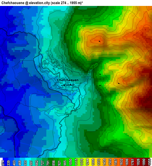
Below is the Elevation map of Chefchaouene, which displays elevation range with different colors. Scale of the first map is from 274 to 1955 m (899 to 6414 ft) with average elevation of 815.7 meters (=2676 ft) [note 1]
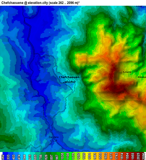
These maps also provides idea of topography and contour of this city, they are displayed at different zoom levels. More info about maps, scale and edge coordinates you can find below images.
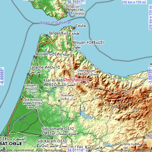
| \ | Map #1 | Map #2 | Topo.Map |
| Scale [m] | 274..1955 m | 262..2096 m | × |
| Scale [ft] | 899..6414 ft | 860..6877 ft | × |
| Average | 815.7 m = 2676 ft | 763.5 m = 2505 ft | × |
| Width | 7.99 km = 5 mi | 15.98 km = 9.9 mi | 255.6 km = 158.8 mi |
| Height | 7.99 km = 5 mi | 15.98 km = 9.9 mi | 255.6 km = 158.8 mi |
| ↑Max Latitude | 35.204696° | 35.240595° | 36.31017° |
| Latitude at center | 35.16878° | 35.16878° | 35.16878° |
| ↓Min Latitude | 35.132849° | 35.096901° | 34.01114° |
| ← Min Longitude | -5.307545° | -5.351491° | -6.66985° |
| Longitude center | -5.2636° | -5.2636° | -5.2636° |
| →Max Longitude | -5.219655° | -5.175709° | -3.85735° |
Nearby cities:
Cities around Chefchaouene sort by population:
• Tétouan elevation 121 m
46.5 km,  348°
348°
• Ouezzane 306 m
50.4 km,  214°
214°
• Martil 5 m
49.8 km,  358°
358°
• Azla 9 m
42.8 km,  2°
2°
• Zoumi 369 m
41.3 km,  190°
190°
• Brikcha 307 m
36 km,  231°
231°
• Oued Laou 20 m
34.6 km,  26°
26°
• Tizgane 9 m
32.3 km, 33°
• Zinat 332 m
31.6 km,  336°
336°
• Fifi 579 m
24.5 km,  176°
176°
• Bab Taza 864 m
13.3 km,  153°
153°
• Derdara 413 m
6.9 km,  200°
200°
Multilingual:
 En español:
Xauen elevación 607 m.
 En France:
Ville de Chechaouèn, Chefchaouen, Chefchaouene élévation 607 m.
 Auf Deutsch:
Chefchaouene höhe über dem Meeresspiegel ist 607 m.

Sources and notes:
- [note 1] Map square and city borders are not equal. Map elevation data is calculated only from area inside that square.
- [src 1] Elevation data from geonames database provided with same terms of usage.
- [src 2] The elevation map of Chefchaouene is generated using elevation data from NASA's 3 arcsec (90m) resolution SRTM data.
- [src 3] Base (background) map © OpenStreetMap contributors tiles are generated by Geofabrik and OpenTopoMap.
Copyright & License:
This Chefchaouene Elevation Map is licensed under CC BY-SA. You may reuse any part from this page, if you give a proper credit by linking to this URL:
 More info on terms of use page.