Amersid elevation
Amersid (Béni Mellal-Khénifra, Khenifra), Morocco elevation is 1207 meters and Amersid elevation in feet is 3960 ft above sea level [src 1]. Amersid is a seat of a third-order administrative division (feature code) with elevation that is 591 meters (1939 ft) bigger than average city elevation in Morocco.
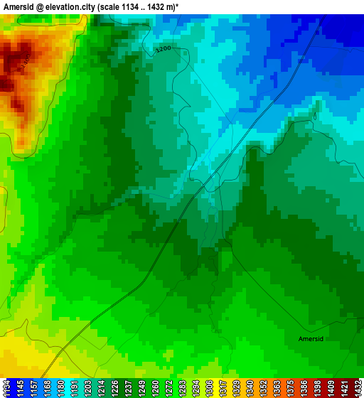
Below is the Elevation map of Amersid, which displays elevation range with different colors. Scale of the first map is from 1134 to 1432 m (3720 to 4698 ft) with average elevation of 1239.5 meters (=4067 ft) [note 1]
These maps also provides idea of topography and contour of this city, they are displayed at different zoom levels. More info about maps, scale and edge coordinates you can find below images.
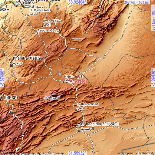
| \ | Map #1 | Topo.Map |
| Scale [m] | 1134..1432 m | × |
| Scale [ft] | 3720..4698 ft | × |
| Average | 1239.5 m = 4067 ft | × |
| Width | 8.22 km = 5.1 mi | 263 km = 163.4 mi |
| Height | 8.22 km = 5.1 mi | 263 km = 163.4 mi |
| ↑Max Latitude | 32.786782° | 33.92464° |
| Latitude at center | 32.74983° | 32.74983° |
| ↓Min Latitude | 32.712863° | 31.55932° |
| ← Min Longitude | -4.514575° | -5.87688° |
| Longitude center | -4.47063° | -4.47063° |
| →Max Longitude | -4.426685° | -3.06438° |
Nearby cities:
Cities around Amersid sort by population:
• Errachidia elevation 1039 m
91.1 km,  177°
177°
• Azrou 1277 m
103.4 km,  317°
317°
• Midelt 1462 m
26.7 km,  254°
254°
• Aïn Leuh 1424 m
100.8 km,  306°
306°
• Talzemt 1780 m
97 km,  15°
15°
• Kerrouchen 1370 m
79.5 km,  273°
273°
• Boulemane 1712 m
72.4 km,  340°
340°
• Almis Marmoucha 1692 m
68.9 km, 23°
• Amouguer 1628 m
68.5 km,  219°
219°
• Boumia 1520 m
59.2 km, 267°
• Itzer 1658 m
56.1 km,  284°
284°
• Missour 883 m
55.9 km,  53°
53°
Multilingual:
 En español:
Amersid elevación 1207 m.
 En France:
Amersid élévation 1207 m.
 Auf Deutsch:
Amersid höhe über dem Meeresspiegel ist 1207 m.

Sources and notes:
- [note 1] Map square and city borders are not equal. Map elevation data is calculated only from area inside that square.
- [src 1] Elevation data from geonames database provided with same terms of usage.
- [src 2] The elevation map of Amersid is generated using elevation data from NASA's 3 arcsec (90m) resolution SRTM data.
- [src 3] Base (background) map © OpenStreetMap contributors tiles are generated by Geofabrik and OpenTopoMap.
Copyright & License:
This Amersid Elevation Map is licensed under CC BY-SA. You may reuse any part from this page, if you give a proper credit by linking to this URL:
 More info on terms of use page.