Azemmour elevation
Azemmour (Casablanca-Settat, El-Jadida), Morocco elevation is 28 meters and Azemmour elevation in feet is 92 ft above sea level [src 1]. Azemmour is a seat of a third-order administrative division (feature code) with elevation that is 588 meters (1929 ft) smaller than average city elevation in Morocco.
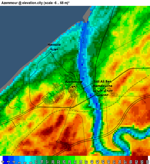
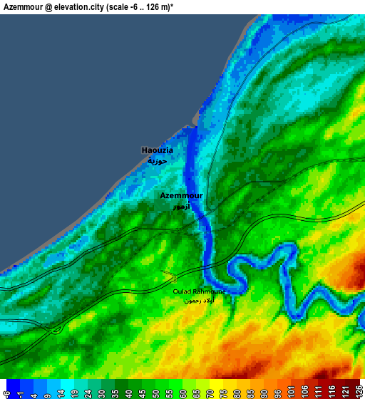
Below is the Elevation map of Azemmour, which displays elevation range with different colors. Scale of the first map is from -6 to 68 m (-20 to 223 ft) with average elevation of 32.1 meters (=105 ft) [note 1]
These maps also provides idea of topography and contour of this city, they are displayed at different zoom levels. More info about maps, scale and edge coordinates you can find below images.
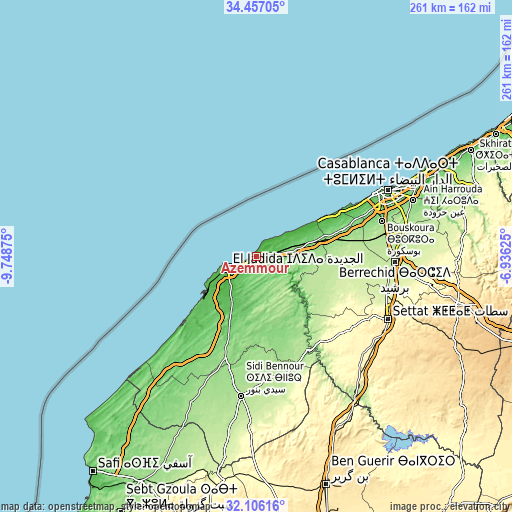
| \ | Map #1 | Map #2 | Topo.Map |
| Scale [m] | -6..68 m | -6..126 m | × |
| Scale [ft] | -20..223 ft | -20..413 ft | × |
| Average | 32.1 m = 105 ft | 44.4 m = 146 ft | × |
| Width | 8.17 km = 5.1 mi | 16.34 km = 10.2 mi | 261.4 km = 162.4 mi |
| Height | 8.17 km = 5.1 mi | 16.34 km = 10.2 mi | 261.4 km = 162.4 mi |
| ↑Max Latitude | 33.326246° | 33.362958° | 34.45705° |
| Latitude at center | 33.28952° | 33.28952° | 33.28952° |
| ↓Min Latitude | 33.252778° | 33.216021° | 32.10616° |
| ← Min Longitude | -8.386445° | -8.430391° | -9.74875° |
| Longitude center | -8.3425° | -8.3425° | -8.3425° |
| →Max Longitude | -8.298555° | -8.254609° | -6.93625° |
Nearby cities:
Cities around Azemmour sort by population:
• Casablanca elevation 27 m
75.5 km,  63°
63°
• El Jadid 10 m
15.9 km,  256°
256°
• Settat 365 m
74.8 km,  115°
115°
• Berrechid 220 m
70.2 km,  92°
92°
• Sidi Bennour 182 m
71.3 km,  186°
186°
• Zawyat an Nwaçer 195 m
67.9 km,  81°
81°
• Sidi Smai’il 151 m
54 km,  196°
196°
• Bouskoura 140 m
66.5 km,  74°
74°
• Dar Bouazza 21 m
54.9 km, 62°
• Boulaouane 179 m
54.7 km,  150°
150°
• Oulad Frej 127 m
38.2 km,  163°
163°
• Moulay Abdallah 19 m
25.1 km,  245°
245°
Multilingual:
 En español:
Azemmour elevación 28 m.
 En France:
Azemmour élévation 28 m.


Sources and notes:
- [note 1] Map square and city borders are not equal. Map elevation data is calculated only from area inside that square.
- [src 1] Elevation data from geonames database provided with same terms of usage.
- [src 2] The elevation map of Azemmour is generated using elevation data from NASA's 3 arcsec (90m) resolution SRTM data.
- [src 3] Base (background) map © OpenStreetMap contributors tiles are generated by Geofabrik and OpenTopoMap.
Copyright & License:
This Azemmour Elevation Map is licensed under CC BY-SA. You may reuse any part from this page, if you give a proper credit by linking to this URL:
 More info on terms of use page.