Zawyat an Nwaçer elevation
Zawyat an Nwaçer (Casablanca-Settat), Morocco elevation is 195 meters and Zawyat an Nwaçer elevation in feet is 640 ft above sea level [src 1]. Zawyat an Nwaçer is a populated place (feature code) with elevation that is 421 meters (1381 ft) smaller than average city elevation in Morocco.
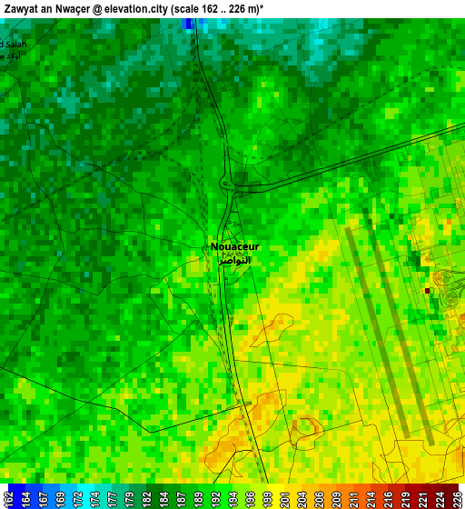
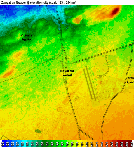
Below is the Elevation map of Zawyat an Nwaçer, which displays elevation range with different colors. Scale of the first map is from 162 to 226 m (531 to 741 ft) with average elevation of 190.3 meters (=624 ft) [note 1]
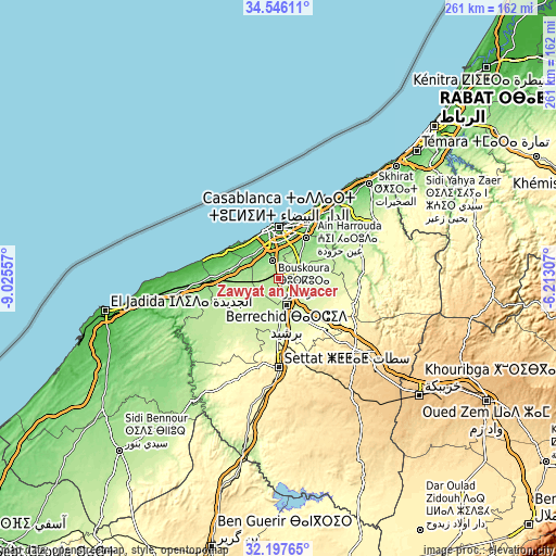
These maps also provides idea of topography and contour of this city, they are displayed at different zoom levels. More info about maps, scale and edge coordinates you can find below images.
| \ | Map #1 | Map #2 | Topo.Map |
| Scale [m] | 162..226 m | 123..244 m | × |
| Scale [ft] | 531..741 ft | 404..801 ft | × |
| Average | 190.3 m = 624 ft | 188.1 m = 617 ft | × |
| Width | 8.16 km = 5.1 mi | 16.32 km = 10.1 mi | 261.1 km = 162.2 mi |
| Height | 8.16 km = 5.1 mi | 16.32 km = 10.1 mi | 261.1 km = 162.2 mi |
| ↑Max Latitude | 33.416498° | 33.453171° | 34.54611° |
| Latitude at center | 33.37981° | 33.37981° | 33.37981° |
| ↓Min Latitude | 33.343106° | 33.306387° | 32.19765° |
| ← Min Longitude | -7.663265° | -7.707211° | -9.02557° |
| Longitude center | -7.61932° | -7.61932° | -7.61932° |
| →Max Longitude | -7.575375° | -7.531429° | -6.21307° |
Nearby cities:
Cities around Zawyat an Nwaçer sort by population:
• Casablanca elevation 27 m
23.2 km,  1°
1°
• Mohammedia 29 m
40.5 km,  32°
32°
• Settat 365 m
42.1 km,  179°
179°
• Berrechid 220 m
13 km,  166°
166°
• Azemmour 28 m
67.9 km,  261°
261°
• Bouznika 43 m
62.3 km,  43°
43°
• Mellila 326 m
44.5 km,  89°
89°
• Riah 357 m
34.1 km,  138°
138°
• Dar Bouazza 21 m
23.7 km,  309°
309°
• Tit Mellil 119 m
23.3 km, 31°
• Mediouna 172 m
12.2 km,  49°
49°
• Bouskoura 140 m
8.4 km,  338°
338°
Multilingual:
 En español:
Zawyat an Nwaçer elevación 195 m.
 En France:
Zawyat an Nwaçer élévation 195 m.
 Auf Deutsch:
Zawyat an Nwaçer höhe über dem Meeresspiegel ist 195 m.

Sources and notes:
- [note 1] Map square and city borders are not equal. Map elevation data is calculated only from area inside that square.
- [src 1] Elevation data from geonames database provided with same terms of usage.
- [src 2] The elevation map of Zawyat an Nwaçer is generated using elevation data from NASA's 3 arcsec (90m) resolution SRTM data.
- [src 3] Base (background) map © OpenStreetMap contributors tiles are generated by Geofabrik and OpenTopoMap.
Copyright & License:
This Zawyat an Nwaçer Elevation Map is licensed under CC BY-SA. You may reuse any part from this page, if you give a proper credit by linking to this URL:
 More info on terms of use page.