Arfoud elevation
Arfoud (Drâa-Tafilalet, Errachidia), Morocco elevation is 809 meters and Arfoud elevation in feet is 2654 ft above sea level [src 1]. Arfoud is a populated place (feature code) with elevation that is 193 meters (633 ft) bigger than average city elevation in Morocco.
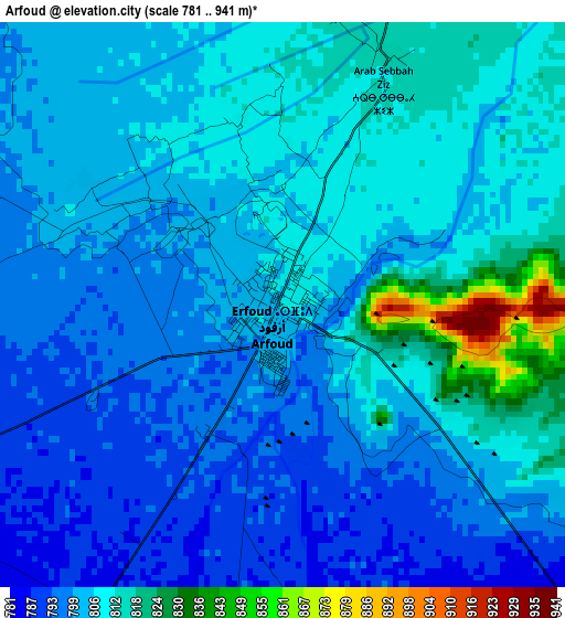
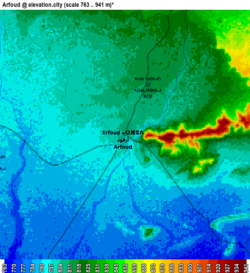
Below is the Elevation map of Arfoud, which displays elevation range with different colors. Scale of the first map is from 781 to 941 m (2562 to 3087 ft) with average elevation of 805 meters (=2641 ft) [note 1]
These maps also provides idea of topography and contour of this city, they are displayed at different zoom levels. More info about maps, scale and edge coordinates you can find below images.
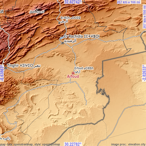
| \ | Map #1 | Map #2 | Topo.Map |
| Scale [m] | 781..941 m | 763..941 m | × |
| Scale [ft] | 2562..3087 ft | 2503..3087 ft | × |
| Average | 805 m = 2641 ft | 802.4 m = 2633 ft | × |
| Width | 8.34 km = 5.2 mi | 16.68 km = 10.4 mi | 266.8 km = 165.8 mi |
| Height | 8.34 km = 5.2 mi | 16.68 km = 10.4 mi | 266.8 km = 165.8 mi |
| ↑Max Latitude | 31.472788° | 31.510261° | 32.62742° |
| Latitude at center | 31.4353° | 31.4353° | 31.4353° |
| ↓Min Latitude | 31.397797° | 31.360279° | 30.22782° |
| ← Min Longitude | -4.276525° | -4.320471° | -5.63883° |
| Longitude center | -4.23258° | -4.23258° | -4.23258° |
| →Max Longitude | -4.188635° | -4.144689° | -2.82633° |
Nearby cities:
Cities around Arfoud sort by population:
• Errachidia elevation 1039 m
58.1 km,  341°
341°
• Midelt 1462 m
147.1 km, 340°
• Tinghir 1281 m
123.6 km,  274°
274°
• Reçani 761 m
17.2 km,  190°
190°
• Jebel Tiskaouine 1025 m
95.5 km,  241°
241°
• Amouguer 1628 m
114.5 km,  324°
324°
• Assoul 1641 m
108.8 km,  301°
301°
• Alnif 871 m
96.1 km,  248°
248°
• Goulmima 1028 m
74 km,  292°
292°
• Aoufous 1031 m
27.8 km,  12°
12°
• Fezna 837 m
23.6 km, 296°
• Jorf 824 m
17.7 km, 291°
Multilingual:
 En español:
Arfoud elevación 809 m.
 En France:
Arfoud élévation 809 m.


Sources and notes:
- [note 1] Map square and city borders are not equal. Map elevation data is calculated only from area inside that square.
- [src 1] Elevation data from geonames database provided with same terms of usage.
- [src 2] The elevation map of Arfoud is generated using elevation data from NASA's 3 arcsec (90m) resolution SRTM data.
- [src 3] Base (background) map © OpenStreetMap contributors tiles are generated by Geofabrik and OpenTopoMap.
Copyright & License:
This Arfoud Elevation Map is licensed under CC BY-SA. You may reuse any part from this page, if you give a proper credit by linking to this URL:
 More info on terms of use page.