Fès elevation
Fès (Fès-Meknès, Fes), Morocco elevation is 406 meters and Fès elevation in feet is 1332 ft above sea level [src 1]. Fès is a seat of a first-order administrative division (feature code) with elevation that is 210 meters (689 ft) smaller than average city elevation in Morocco.
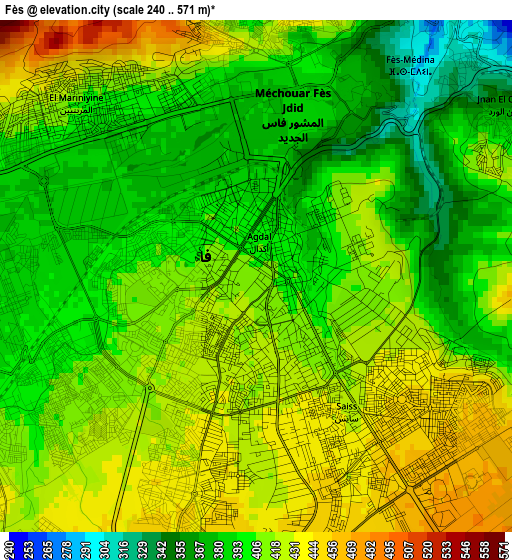
Below is the Elevation map of Fès, which displays elevation range with different colors. Scale of the first map is from 240 to 571 m (787 to 1873 ft) with average elevation of 407.2 meters (=1336 ft) [note 1]
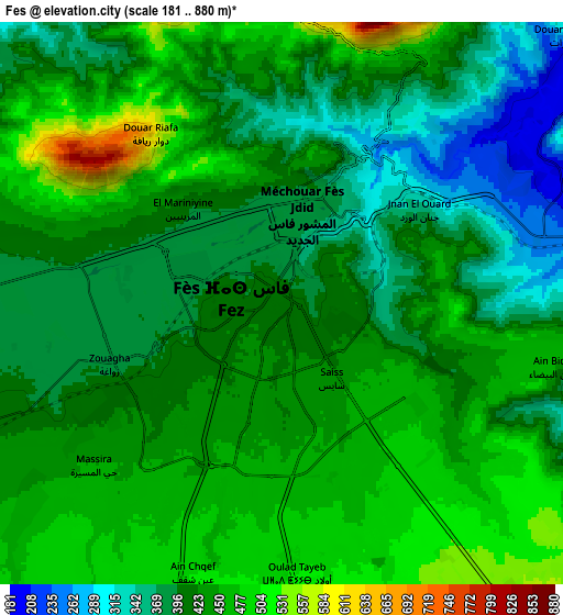
These maps also provides idea of topography and contour of this city, they are displayed at different zoom levels. More info about maps, scale and edge coordinates you can find below images.
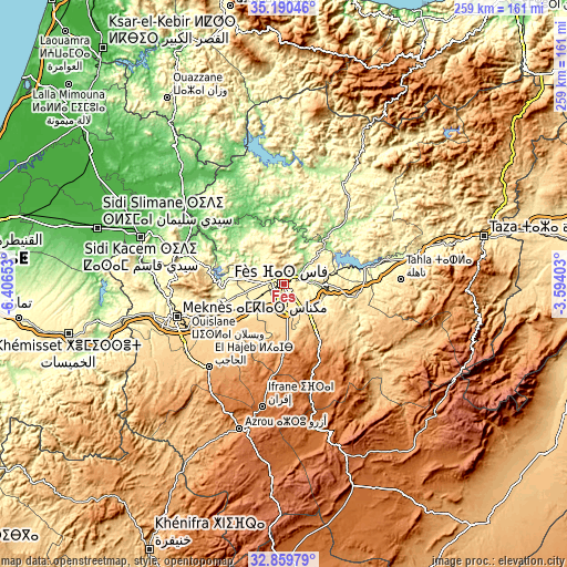
| \ | Map #1 | Map #2 | Topo.Map |
| Scale [m] | 240..571 m | 181..880 m | × |
| Scale [ft] | 787..1873 ft | 594..2887 ft | × |
| Average | 407.2 m = 1336 ft | 424.4 m = 1392 ft | × |
| Width | 8.1 km = 5 mi | 16.2 km = 10.1 mi | 259.1 km = 161 mi |
| Height | 8.1 km = 5 mi | 16.2 km = 10.1 mi | 259.1 km = 161 mi |
| ↑Max Latitude | 34.06954° | 34.105935° | 35.19046° |
| Latitude at center | 34.03313° | 34.03313° | 34.03313° |
| ↓Min Latitude | 33.996704° | 33.960263° | 32.85979° |
| ← Min Longitude | -5.044225° | -5.088171° | -6.40653° |
| Longitude center | -5.00028° | -5.00028° | -5.00028° |
| →Max Longitude | -4.956335° | -4.912389° | -3.59403° |
Nearby cities:
Cities around Fès sort by population:
• Fès al Bali elevation 237 m
5.9 km,  45°
45°
• Sefrou 809 m
27.4 km,  144°
144°
• El Hajeb 1023 m
51.4 km,  221°
221°
• Oulad Tayeb 533 m
9.7 km,  177°
177°
• Oulad Daoud 362 m
50 km,  34°
34°
• Karia Ba Mohamed 160 m
42.4 km,  332°
332°
• Tissa 214 m
42 km, 47°
• Matmata 306 m
41.9 km,  79°
79°
• Bouarouss 247 m
40.3 km, 25°
• Bhalil 945 m
23.4 km,  149°
149°
• Moulay Yacoub 254 m
17.8 km,  290°
290°
• Sidi Harazem 257 m
10.8 km,  93°
93°
Multilingual:
 En español:
Fez elevación 406 m.
 En France:
Fès élévation 406 m.


Sources and notes:
- [note 1] Map square and city borders are not equal. Map elevation data is calculated only from area inside that square.
- [src 1] Elevation data from geonames database provided with same terms of usage.
- [src 2] The elevation map of Fès is generated using elevation data from NASA's 3 arcsec (90m) resolution SRTM data.
- [src 3] Base (background) map © OpenStreetMap contributors tiles are generated by Geofabrik and OpenTopoMap.
Copyright & License:
This Fès Elevation Map is licensed under CC BY-SA. You may reuse any part from this page, if you give a proper credit by linking to this URL:
 More info on terms of use page.