Guelmim elevation
Guelmim (Guelmim-Oued Noun), Morocco elevation is 301 meters and Guelmim elevation in feet is 988 ft above sea level [src 1]. Guelmim is a seat of a first-order administrative division (feature code) with elevation that is 315 meters (1033 ft) smaller than average city elevation in Morocco.
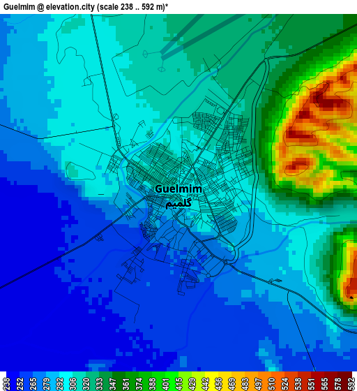
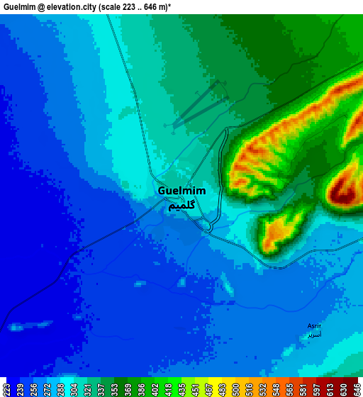
Below is the Elevation map of Guelmim, which displays elevation range with different colors. Scale of the first map is from 238 to 592 m (781 to 1942 ft) with average elevation of 303.1 meters (=994 ft) [note 1]
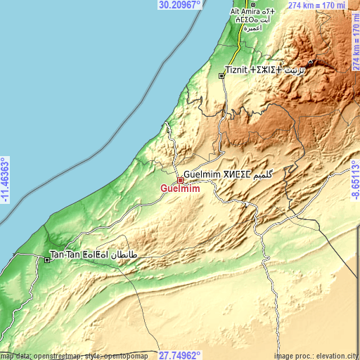
These maps also provides idea of topography and contour of this city, they are displayed at different zoom levels. More info about maps, scale and edge coordinates you can find below images.
| \ | Map #1 | Map #2 | Topo.Map |
| Scale [m] | 238..592 m | 223..646 m | × |
| Scale [ft] | 781..1942 ft | 732..2119 ft | × |
| Average | 303.1 m = 994 ft | 298.9 m = 981 ft | × |
| Width | 8.55 km = 5.3 mi | 17.1 km = 10.6 mi | 273.5 km = 169.9 mi |
| Height | 8.55 km = 5.3 mi | 17.1 km = 10.6 mi | 273.5 km = 169.9 mi |
| ↑Max Latitude | 29.025393° | 29.063812° | 30.20967° |
| Latitude at center | 28.98696° | 28.98696° | 28.98696° |
| ↓Min Latitude | 28.948513° | 28.910051° | 27.74962° |
| ← Min Longitude | -10.101325° | -10.145271° | -11.46363° |
| Longitude center | -10.05738° | -10.05738° | -10.05738° |
| →Max Longitude | -10.013435° | -9.969489° | -8.65113° |
Nearby cities:
Cities around Guelmim sort by population:
• Agadir elevation 31 m
165.4 km,  15°
15°
• Tan-Tan 45 m
118.9 km,  239°
239°
• Dakhla 83 m
165.6 km, 17°
• Tiznit 240 m
85.1 km, 21°
• Sidi Ifni 44 m
45.1 km,  345°
345°
• Tafraout 993 m
133.2 km,  51°
51°
• Tabia 1119 m
163.1 km,  44°
44°
• Inezgane 31 m
160.3 km, 18°
• Tanalt 932 m
122.9 km, 44°
• Tarsouat 1054 m
119.8 km,  56°
56°
• Ouijjane 306 m
87.2 km, 35°
• Reggada 387 m
74.5 km,  27°
27°
Multilingual:
 En español:
Guelmim elevación 301 m.
 En France:
Guelmim élévation 301 m.
 Auf Deutsch:
Guelmim, Kulmīm höhe über dem Meeresspiegel ist 301 m.

Sources and notes:
- [note 1] Map square and city borders are not equal. Map elevation data is calculated only from area inside that square.
- [src 1] Elevation data from geonames database provided with same terms of usage.
- [src 2] The elevation map of Guelmim is generated using elevation data from NASA's 3 arcsec (90m) resolution SRTM data.
- [src 3] Base (background) map © OpenStreetMap contributors tiles are generated by Geofabrik and OpenTopoMap.
Copyright & License:
This Guelmim Elevation Map is licensed under CC BY-SA. You may reuse any part from this page, if you give a proper credit by linking to this URL:
 More info on terms of use page.