Agadir elevation
Agadir (Souss-Massa, Agadir-Ida-ou-Tnan), Morocco elevation is 31 meters and Agadir elevation in feet is 102 ft above sea level [src 1]. Agadir is a seat of a first-order administrative division (feature code) with elevation that is 585 meters (1919 ft) smaller than average city elevation in Morocco.
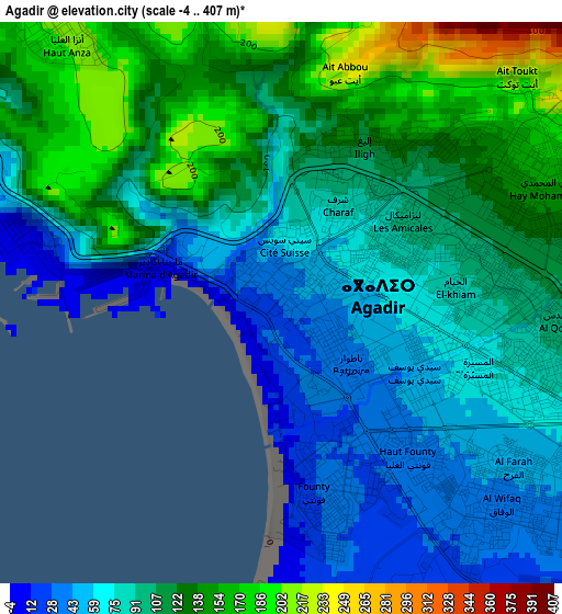
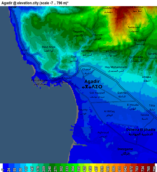
Below is the Elevation map of Agadir, which displays elevation range with different colors. Scale of the first map is from -4 to 407 m (-13 to 1335 ft) with average elevation of 101.4 meters (=333 ft) [note 1]
These maps also provides idea of topography and contour of this city, they are displayed at different zoom levels. More info about maps, scale and edge coordinates you can find below images.
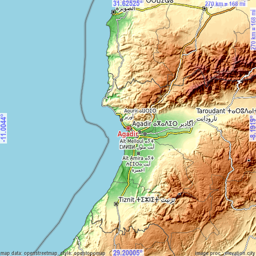
| \ | Map #1 | Map #2 | Topo.Map |
| Scale [m] | -4..407 m | -7..796 m | × |
| Scale [ft] | -13..1335 ft | -23..2612 ft | × |
| Average | 101.4 m = 333 ft | 157.7 m = 517 ft | × |
| Width | 8.43 km = 5.2 mi | 16.85 km = 10.5 mi | 269.7 km = 167.6 mi |
| Height | 8.43 km = 5.2 mi | 16.85 km = 10.5 mi | 269.7 km = 167.6 mi |
| ↑Max Latitude | 30.458068° | 30.495942° | 31.62525° |
| Latitude at center | 30.42018° | 30.42018° | 30.42018° |
| ↓Min Latitude | 30.382277° | 30.344359° | 29.20005° |
| ← Min Longitude | -9.642095° | -9.686041° | -11.0044° |
| Longitude center | -9.59815° | -9.59815° | -9.59815° |
| →Max Longitude | -9.554205° | -9.510259° | -8.1919° |
Nearby cities:
Cities around Agadir sort by population:
• Taroudant elevation 237 m
69.4 km,  85°
85°
• Oulad Teïma 129 m
37.4 km, 94°
• Dakhla 83 m
4.2 km,  104°
104°
• Timezgadiouine 917 m
73.8 km,  45°
45°
• Tamanar 320 m
65 km,  353°
353°
• Argana 768 m
61 km, 48°
• Bigoudine 741 m
50.1 km, 47°
• Tadrart 900 m
41.6 km,  18°
18°
• Tamri 14 m
37.8 km,  324°
324°
• Taghazout 1 m
17.4 km, 321°
• Inezgane 31 m
9.3 km,  140°
140°
• Aourir 121 m
8.8 km,  335°
335°
Multilingual:
 En español:
Agadir elevación 31 m.
 En France:
Agadir élévation 31 m.


Sources and notes:
- [note 1] Map square and city borders are not equal. Map elevation data is calculated only from area inside that square.
- [src 1] Elevation data from geonames database provided with same terms of usage.
- [src 2] The elevation map of Agadir is generated using elevation data from NASA's 3 arcsec (90m) resolution SRTM data.
- [src 3] Base (background) map © OpenStreetMap contributors tiles are generated by Geofabrik and OpenTopoMap.
Copyright & License:
This Agadir Elevation Map is licensed under CC BY-SA. You may reuse any part from this page, if you give a proper credit by linking to this URL:
 More info on terms of use page.