Khouribga elevation
Khouribga (Béni Mellal-Khénifra, Khouribga Province), Morocco elevation is 804 meters and Khouribga elevation in feet is 2638 ft above sea level [src 1]. Khouribga is a seat of a third-order administrative division (feature code) with elevation that is 188 meters (617 ft) bigger than average city elevation in Morocco.
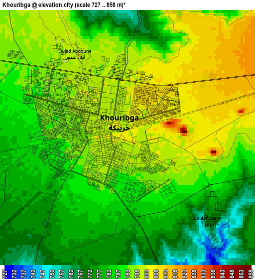
Below is the Elevation map of Khouribga, which displays elevation range with different colors. Scale of the first map is from 727 to 858 m (2385 to 2815 ft) with average elevation of 790.2 meters (=2593 ft) [note 1]
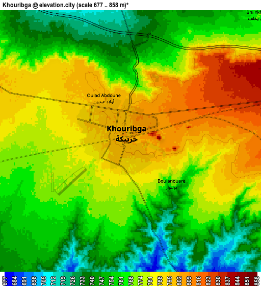
These maps also provides idea of topography and contour of this city, they are displayed at different zoom levels. More info about maps, scale and edge coordinates you can find below images.
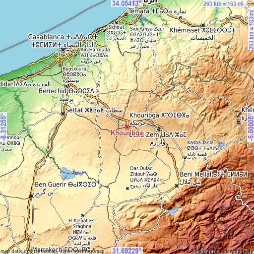
| \ | Map #1 | Map #2 | Topo.Map |
| Scale [m] | 727..858 m | 677..858 m | × |
| Scale [ft] | 2385..2815 ft | 2221..2815 ft | × |
| Average | 790.2 m = 2593 ft | 770.3 m = 2527 ft | × |
| Width | 8.21 km = 5.1 mi | 16.41 km = 10.2 mi | 262.6 km = 163.2 mi |
| Height | 8.21 km = 5.1 mi | 16.41 km = 10.2 mi | 262.6 km = 163.2 mi |
| ↑Max Latitude | 32.917978° | 32.95486° | 34.05413° |
| Latitude at center | 32.88108° | 32.88108° | 32.88108° |
| ↓Min Latitude | 32.844167° | 32.807239° | 31.69229° |
| ← Min Longitude | -6.950245° | -6.994191° | -8.31255° |
| Longitude center | -6.9063° | -6.9063° | -6.9063° |
| →Max Longitude | -6.862355° | -6.818409° | -5.50005° |
Nearby cities:
Cities around Khouribga sort by population:
• Settat elevation 365 m
67.6 km,  281°
281°
• Oued Zem 783 m
31.1 km,  93°
93°
• Al Fqih Ben Çalah 444 m
46.8 km,  154°
154°
• Kasba Tadla 499 m
67.5 km,  117°
117°
• Boujniba 847 m
12.5 km,  80°
80°
• Sidi Moussa 354 m
73.1 km,  202°
202°
• Sidi Jaber 469 m
71.1 km,  140°
140°
• Dar Ould Zidouh 375 m
63.2 km,  179°
179°
• Mellila 326 m
59.6 km,  338°
338°
• Ezzhiliga 718 m
58.3 km,  36°
36°
• Guisser 498 m
56.8 km,  257°
257°
• Riah 357 m
53 km,  304°
304°
Multilingual:
 En español:
Khouribga elevación 804 m.
 En France:
Khouribga élévation 804 m.
 Auf Deutsch:
Khouribga höhe über dem Meeresspiegel ist 804 m.

Sources and notes:
- [note 1] Map square and city borders are not equal. Map elevation data is calculated only from area inside that square.
- [src 1] Elevation data from geonames database provided with same terms of usage.
- [src 2] The elevation map of Khouribga is generated using elevation data from NASA's 3 arcsec (90m) resolution SRTM data.
- [src 3] Base (background) map © OpenStreetMap contributors tiles are generated by Geofabrik and OpenTopoMap.
Copyright & License:
This Khouribga Elevation Map is licensed under CC BY-SA. You may reuse any part from this page, if you give a proper credit by linking to this URL:
 More info on terms of use page.