Kasba Tadla elevation
Kasba Tadla (Béni Mellal-Khénifra, Beni-Mellal), Morocco elevation is 499 meters and Kasba Tadla elevation in feet is 1637 ft above sea level [src 1]. Kasba Tadla is a seat of a third-order administrative division (feature code) with elevation that is 117 meters (384 ft) smaller than average city elevation in Morocco.
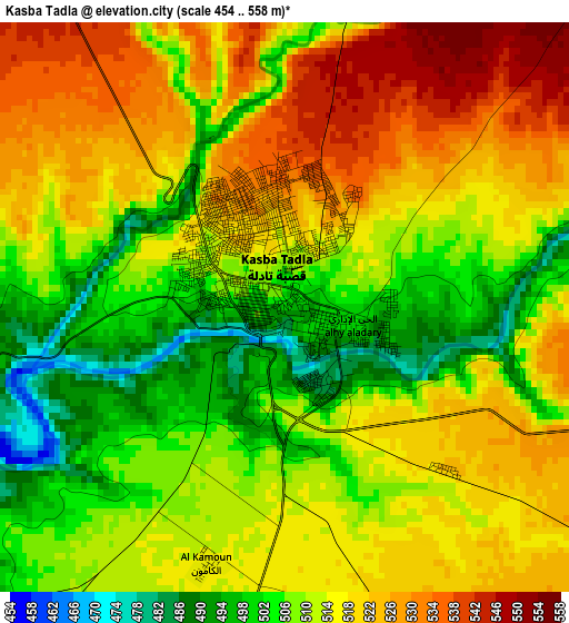
Below is the Elevation map of Kasba Tadla, which displays elevation range with different colors. Scale of the first map is from 454 to 558 m (1490 to 1831 ft) with average elevation of 513.4 meters (=1684 ft) [note 1]
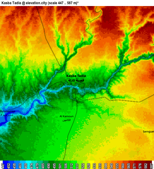
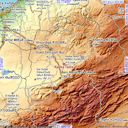
These maps also provides idea of topography and contour of this city, they are displayed at different zoom levels. More info about maps, scale and edge coordinates you can find below images.
| \ | Map #1 | Map #2 | Topo.Map |
| Scale [m] | 454..558 m | 447..587 m | × |
| Scale [ft] | 1490..1831 ft | 1467..1926 ft | × |
| Average | 513.4 m = 1684 ft | 525.8 m = 1725 ft | × |
| Width | 8.23 km = 5.1 mi | 16.47 km = 10.2 mi | 263.4 km = 163.7 mi |
| Height | 8.23 km = 5.1 mi | 16.47 km = 10.2 mi | 263.5 km = 163.7 mi |
| ↑Max Latitude | 32.634715° | 32.671715° | 33.77455° |
| Latitude at center | 32.5977° | 32.5977° | 32.5977° |
| ↓Min Latitude | 32.56067° | 32.523624° | 31.40519° |
| ← Min Longitude | -6.312385° | -6.356331° | -7.67469° |
| Longitude center | -6.26844° | -6.26844° | -6.26844° |
| →Max Longitude | -6.224495° | -6.180549° | -4.86219° |
Nearby cities:
Cities around Kasba Tadla sort by population:
• Beni Mellal elevation 538 m
29.9 km,  194°
194°
• Oued Zem 783 m
41 km,  315°
315°
• Al Fqih Ben Çalah 444 m
40.7 km,  254°
254°
• Boujniba 847 m
58.1 km,  305°
305°
• Zawyat ech Cheïkh 718 m
33.2 km,  80°
80°
• Taounza 681 m
64.4 km,  209°
209°
• Sidi Amar 905 m
56.5 km,  46°
46°
• Timoulilt 604 m
47.6 km,  203°
203°
• Isseksi 1407 m
40.9 km,  181°
181°
• Sidi Lamine 733 m
40 km,  30°
30°
• Sidi Jaber 469 m
27.2 km, 211°
• El Ksiba 1079 m
23.5 km,  96°
96°
Multilingual:
 En español:
Kasba Tadla elevación 499 m.
 En France:
Kasba Tadla élévation 499 m.
 Auf Deutsch:
Kasba Tadla höhe über dem Meeresspiegel ist 499 m.

Sources and notes:
- [note 1] Map square and city borders are not equal. Map elevation data is calculated only from area inside that square.
- [src 1] Elevation data from geonames database provided with same terms of usage.
- [src 2] The elevation map of Kasba Tadla is generated using elevation data from NASA's 3 arcsec (90m) resolution SRTM data.
- [src 3] Base (background) map © OpenStreetMap contributors tiles are generated by Geofabrik and OpenTopoMap.
Copyright & License:
This Kasba Tadla Elevation Map is licensed under CC BY-SA. You may reuse any part from this page, if you give a proper credit by linking to this URL:
 More info on terms of use page.